Faray
| Faray | |
|---|---|
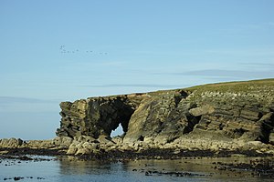
(c) George Brown, CC BY-SA 2.0 | |
| Gewässer | Nordsee |
| Inselgruppe | Orkney Archipels |
| Geographische Lage | 59° 13′ 0″ N, 2° 49′ 0″ W |
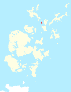
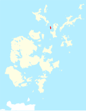
Contains Ordnance Survey data © Crown copyright and database right, CC BY-SA 3.0 | |
| Fläche | 1,8 km² |
| Höchste Erhebung | 32 m |
| Einwohner | unbewohnt |
| Ordnance-Survey-Kartenblatt (1959) | |
Faray (Altnord. Faer-ey dt. Schafsinsel; lokal auch Fara) ist eine kleine Insel im nördlichen Teil der Orkney. Gemeinsam mit der nördlich gelegenen Insel Holm of Faray markiert sie die höchsten Punkte einer Landbrücke zwischen den Inseln Eday und Westray, wie sie in der Jungsteinzeit bestand. Die Insel hat eine interessante Küste mit Geos[1], Höhlen und einem Sandstrand am Südende.
Faray ist seit 1946 unbewohnt. Beide Inseln werden aber wegen der Weidegründe bis heute saisonal als Schafweide genutzt. Mehrere kleinere Bodendenkmale und die Ruinen von acht Cottages zeugen von der ehemaligen Besiedlung.
Am südlichen Ende gibt es vier gut erhalten Nausts (lokal nousts) mit spitzen Enden. Das größte ist acht Meter lang und 2,3 m breit. Der Stalled Cairn auf Faray mit einigen aufrechten Platten in situ befindet sich am nördlichen Ende der Insel, in der Nähe der Küste auf der Westseite. Er kann „Hörner“ an jeder Ecke gehabt haben, was auf einen Heel-shaped Cairn weist.
Auf dem „Holm of Faray“ weist ein Steinareal an der Südwestecke auf zwei bronzezeitliche Häuser. Eines ist eine große ovale Struktur mit radialen Trennwänden, etwa ein Wheelhouse. Der Holm ist eine Gezeiteninsel und wird bei Flut von Faray getrennt.
Einzelnachweise
Weblinks
Auf dieser Seite verwendete Medien
2007 Flag of Orkney
My own vector of the official flag of the Isles of Orkney, Scotland, created using Inkscape. This version is based upon the official version designed by Duncan Tullock of Birsay and voted for by the people of Orkney and approved by the Court of the Lord Lyon in 2007 from a short list of 5 designs. It is a Nordic Cross, in keeping with the flag's unofficial predecesor the Cross of St Magnus, and for which, according to Mr Tullock, "Orkney has always been represented by red, so that was an obvious choice. The yellow symbolizes the royal standards of both Scotland and Norway and blue is for Scotland, and also for the sea that surrounds us".
Contains Ordnance Survey data © Crown copyright and database right, CC BY-SA 3.0
Faray, in Orkney
OS Map of the central part of the Orkney Islands including Mainland, at a scale of 1:63,360 or one inch to one mile.
(c) George Brown, CC BY-SA 2.0
Natural arch through North end of Holm of Faray This natural arch, through the sandstone cliffs of Holm of Faray, is a good example of the many caves and geos found in this area. The Holm is home to many Common seals. Note the flock of Greylag geese winging their way towards Westray. A very low tide was experienced this day due to the high pressure weather system Orkney was fortunate to experience this last week.


