Fara (Insel)
| Fara | |
|---|---|
(c) Dave Simpson, CC BY-SA 2.0 | |
| Gewässer | Nordsee |
| Inselgruppe | Orkney-Inseln |
| Geographische Lage | 58° 50′ 41″ N, 3° 9′ 58″ W |
Contains Ordnance Survey data © Crown copyright and database right, CC BY-SA 3.0 | |
| Fläche | 2,95 km² |
| Einwohner | unbewohnt |
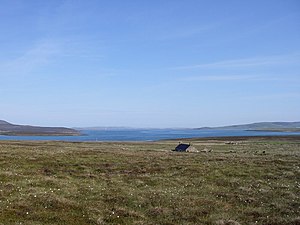
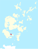
Die Insel Fara (Foerey – „Schafsinsel“) gehört zum Archipel der Orkney etwa 30 km nördlich von Schottland. Im Archipel liegt sie zwischen den Inseln Hoy und Flotta in der Bucht von Scapa Flow. Die Insel ist 295 ha groß und seit 1947 unbewohnt.
Im Zweiten Weltkrieg stiegen von hier Sperrballons auf.
Das Wind-Energieprojekt von 2010 sieht den Bau von Wind-Turbinen auf Fara vor.
Literatur
- Charles Tait: The Orkney Guide Book. Edition 2.1. C. Tait, Kelton – St. Ola – Orkney 1999, ISBN 0-9517859-0-7, S. 167.
- John R. Hunter, Stephen J. Dockrill, Jacqueline I. McKinley: The Sites and Monuments of Fara, Orkney (= Bradford University School of Archaeological Sciences Occasional Papers. Nr. 1). School of Archaeological Sciences – University of Bradford, Bradford 1982.
Auf dieser Seite verwendete Medien
2007 Flag of Orkney
My own vector of the official flag of the Isles of Orkney, Scotland, created using Inkscape. This version is based upon the official version designed by Duncan Tullock of Birsay and voted for by the people of Orkney and approved by the Court of the Lord Lyon in 2007 from a short list of 5 designs. It is a Nordic Cross, in keeping with the flag's unofficial predecesor the Cross of St Magnus, and for which, according to Mr Tullock, "Orkney has always been represented by red, so that was an obvious choice. The yellow symbolizes the royal standards of both Scotland and Norway and blue is for Scotland, and also for the sea that surrounds us".
Contains Ordnance Survey data © Crown copyright and database right, CC BY-SA 3.0
Fara, in Orkney
(c) Kelisi aus der englischsprachigen Wikipedia, CC BY-SA 3.0
A map of the Pentland Firth, northern Scotland, showing various towns and villages on the British mainland and in Orkney, as well as physical features, including islands in the Firth. This map's source is here, with the uploader's modifications, and the GMT homepage says that the tools are released under the GNU General Public License.
(c) Dave Simpson, CC BY-SA 2.0
Abandoned House, Fara, Orkney Islands. Looking North: Rysa Little with Hoy behind to left; Graemsay with Mainland behind centre and right; Cava to right.


