Fanna (Insel)
| Fanna | ||
|---|---|---|
 | ||
| Gewässer | Pazifischer Ozean | |
| Inselgruppe | Sonsorol-Inseln | |
| Geographische Lage | 5° 21′ 13″ N, 132° 13′ 38″ O | |
| Länge | 740 m | |
| Breite | 500 m | |
| Fläche | 54 ha | |
| Höchste Erhebung | 1 m | |
| Einwohner | unbewohnt | |
 | ||
Fanna, auch Fana genannt, ist eine kleine Insel im Westpazifik. Sie liegt 1,7 km nördlich ihrer Schwesterinsel Dongosaro, mit welcher sie die Gruppe der Sonsorol-Inseln bildet.
Die dicht bewaldete Insel wird von einem Korallenriff umgeben, das 160 bis 480 m vom Land entfernt ist, und einen Durchmesser von 350 m aufweist. Die Hauptpflanzen der Insel sind Pisonia-Bäume sowie Kokospalmen. Fanna ist unbewohnt und hat eine Fläche von 0,54 km².
Gemeinsam mit den Inseln Dongosaro, Pulo Anna und Merir bildet das Inselchen den Staat Sonsorol, das heißt, ein Verwaltungsgebiet der Inselrepublik Palau.
Weblinks
Auf dieser Seite verwendete Medien
Autor/Urheber: NordNordWest, Lizenz: CC BY-SA 3.0 de
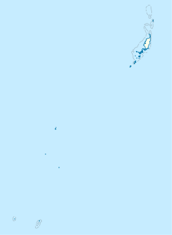
Positionskarte von Palau
Satellite view of the Sonsorol Islands (Dongosaro and Fanna).
South side of Fanna Island, as seen from Dongosaro (Sonsorol) Island, Southwest Islands of Palau. Original field note: Fanna is very close to the inhabited island of Sonsorol, and is visited frequently for coconut crabs and seabirds, as well as for relaxation.


