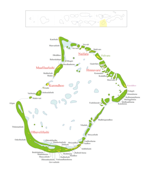
Faadhippolhu-Atoll
| Faadhippolhu-Atoll (Lhaviyani) | ||
|---|---|---|
 | ||
| Gewässer | Lakkadivensee (Indischer Ozean) | |
| Archipel | Malediven | |
| Geographische Lage | 5° 20′ N, 73° 30′ O | |
| Anzahl der Inseln | 55[1] | |
| Hauptinsel | Naifaru | |
| Länge | 36 km | |
| Breite | 24 km | |
| Landfläche | 7,2 km² | |
| Gesamtfläche | 701,46 km² | |
| Einwohner | 9190 (2006[2]) | |
 | ||
Das Faadhippolhu-Atoll (auch Fadiffolu, Dhivehi ފާދިއްޕޮޅު) ist ein Atoll der Malediven. Es liegt nördlich des Nord-Malé-Atolls und ist deckungsgleich mit dem Gebiet des Verwaltungs-Atoll Lhaviyani.
Mit einer Gesamtfläche von 701,46 km² ist das Faadhippolhu-Atoll das zwölftgrößte Atoll der Malediven. Die aggregierte Landfläche der Inseln beträgt dagegen nur 7,20 km² oder etwa ein Prozent der Gesamtfläche.[3]
Geographie

Von den 55[1] Inseln des Faadhippolhu-Atolls sind fünf bewohnt. Es sind dies Hinnavaru, Kurendhoo, Maafilaafushi, Naifaru und Olhuvelifushi.
Weblinks
Einzelnachweise
- ↑ a b The President's Office (Maledives): Isles - Lhaviyani. In: isles.gov.mv. 2022, abgerufen am 14. Februar 2022.
- ↑ Statistical Yearbook of the Maldives 2011, statisticsmaldives.gov.mv
- ↑ National Adaptation Programme of Action (NAPA). (Memento des vom 24. Februar 2015 im Internet Archive) Info: Der Archivlink wurde automatisch eingesetzt und noch nicht geprüft. Bitte prüfe Original- und Archivlink gemäß Anleitung und entferne dann diesen Hinweis. (PDF; 6,2 MB) Ministry of Environment, Energy and Water
Auf dieser Seite verwendete Medien
Flagge der Malediven.
This image (Landsat 7) shows Faadhippolhu atoll in the Lhaviyani district of the Maledives.
Autor/Urheber: helix84, Lizenz: CC BY-SA 3.0
Beschreibung
Map of w:Alif_Alif_Atoll
Map originally vector'ed by Hassan Waheed, Aabaadhuge of Thinadhoo island.
Note: This section of map was extracted and its text was romanized by Oblivious. Special assitance by Waddey and Zuru
Converted to PNG by helix84
- source: Image:Alif_Alif_Atoll.jpg
Autor/Urheber: Carport, Lizenz: CC BY-SA 3.0
Physische Positionskarte der Malediven


