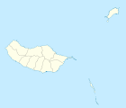
Estreito de Câmara de Lobos
| Estreito de Câmara de Lobos | ||||||
|---|---|---|---|---|---|---|
| ||||||
| Basisdaten | ||||||
| Autonome Region: | Madeira | |||||
| Concelho: | Câmara de Lobos | |||||
| Koordinaten: | 32° 40′ N, 16° 59′ W | |||||
| Einwohner: | 9348 (Stand: 19. April 2021)[1] | |||||
| Fläche: | 7,87 km² (Stand: 1. Januar 2010)[2] | |||||
| Bevölkerungsdichte: | 1188 Einwohner pro km² | |||||
| Postleitzahl: | 9325-018 | |||||
Estreito de Câmara de Lobos ist eine portugiesische Gemeinde (Freguesia) im Kreis Câmara de Lobos. In ihr leben 9348 Einwohner (Stand 19. April 2021).[1]
Sehenswürdigkeiten

Söhne und Töchter
- Armando Eduardo Pinto Correia (1897–1943), Militär, Kolonialverwalter, Autor und Journalist
Einzelnachweise
- ↑ a b www.ine.pt – Indikator Resident population by Place of residence and Sex; Decennial in der Datenbank des Instituto Nacional de Estatística
- ↑ Übersicht über Code-Zuordnungen von Freguesias auf epp.eurostat.ec.europa.eu
Auf dieser Seite verwendete Medien
Autor/Urheber: RHaworth, Lizenz: CC BY-SA 3.0
The church of Our Lady of Grace at 32°40′16″N 16°58′48″W / 32.671022°N 16.979955°W in Estreito de Câmara de Lobos, Madeira (diocesan website). The street, Rua Cónego Agostinho Figueira de Faria was named after an ecclesiastical son of the parish: "by resolution buddy of 18 May 1995 the City Council Chamber of the Wolves gave their name to the street between the apricot and Largo's skate"[1]. More images.
Autor/Urheber: NordNordWest, Lizenz: CC BY-SA 2.0
Positionskarte von Madeira, Portugal
Autor/Urheber: Sérgio Horta, Lizenz: CC BY-SA 3.0
Flag of Câmara de Lobos (Madeira, Portugal)


