Erebus (Marskrater)
| Marskrater Erebus | ||
|---|---|---|
| ||
| Position | 2° 6′ S, 5° 30′ W | |
| Entdeckung | Opportunity | |
| Eponym | HMS Erebus | |
Erebus ist ein Impaktkrater auf dem Mars. Er hat einen Durchmesser von 350 m und befindet sich auf der Meridiani-Planum-Hochebene innerhalb des MC-19 Margaritifer Sinus Gradfeldes. Er wurde vom Opportunity Rover auf seinem Weg zum sehr viel größeren Victoria-Krater besucht. Namensgeberin für diesen Krater ist das Expeditionsschiff HMS Erebus, mit der James Clark Ross das Ross-Schelfeis entdeckte. Weiterhin war die Erebus Flaggschiff der verschwundenen Franklin-Expedition.
Der Rover erreichte die unmittelbare Nähe des Kraters im Oktober 2005 und blieb dort bis März 2006 (Sol 550 bis Sol 750).
Der Krater liegt etwa 2500 Meter südlich des kleineren Wostok-Kraters, den Opportunity zuvor untersucht hatte. An seiner westlichen Seite befindet sich ein flacher Felsaufschluss names Payson Ridge und an seinem nordwestlichen Rand einen Felsaufschluss der Olympia Ridge genannt wird. Die Topographie des Kraters wird von Geologen auch als echted terrain bezeichnet – dabei handelt es sich um relativ flaches Terrain, bei dem flache Felsen ein Gebiet mit Dünen umschließen.
Der Payson Ridge auf der westlichen Seite des Kraters.

Olympia Ridge am nordwestlichen Rand des Kraters

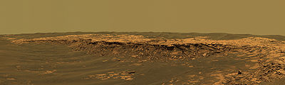
Panoramafarbbild aufgenommen von Opportunity am Kraterrand. Der Krater selbst befindet sich in dem flachen Gebiet oben in der Mitte.

Fahrstrecke von Opportunity. Erebus befindet sich etwa in der Mitte des Bildes.
Siehe auch
Weblinks
- Astronomy Picture of the Day from Nov 8 2005 on Erebus and Opportunity Rover
- Grotzinger, et al., J. Bell, K. Herkenhoff, J. Johnson, A. Knoll, E. McCartney, S. McLennan, J. Metz: Sedimentary textures formed by aqueous processes, Erebus crater, Meridiani Planum, Mars. In: Geology. 34, Nr. 12, 2006, S. 1085–1088. bibcode:2006Geo....34.1085G. doi:10.1130/G22985A.1.
- Structure and Sedimentology of the Western Margin of Erebus Crater, Meridiani Planum, Mars
Auf dieser Seite verwendete Medien

This is the Opportunity panoramic camera's "Erebus Rim" panorama, acquired on sols 652 to 663 (Nov. 23 to Dec. 5, 2005 ), as NASA's Mars Exploration Rover Opportunity was exploring sand dunes and outcrop rocks in Meridiani Planum. The panorama originally consisted of 635 separate images in four different Pancam filters, and covers 360 degrees of terrain around the rover and the full rover deck. Since the time that this panorama was acquired, and while engineers have been diagnosing and testing Opportunity's robotic arm, the panorama has been expanded to include more than 1,300 images of this terrain through all of the Pancam multispectral filters. It is the largest panorama acquired by either rover during the mission.
The panorama shown here is an approximate true-color rendering using Pancam's 750 nanometer, 530 nanometer and 430 nanometer filters. It is presented here as a cylindrical projection. Image-to-image seams have been eliminated from the sky portion of the mosaic to better simulate the vista a person standing on Mars would see.
This panorama provides the team's highest resolution view yet of the finely-layered outcrop rocks, wind ripples, and small cobbles and grains along the rim of the wide but shallow "Erebus" crater. Once the arm diagnostics and testing are completed, the team hopes to explore other layered outcrop rocks at Erebus and then eventually continue southward toward the large crater known as "Victoria."
The panoramic camera aboard NASA's Mars Exploration Rover Opportunity acquired this panorama of the "Payson" outcrop on the western edge of "Erebus" Crater during Opportunity's sol 744 (Feb. 26, 2006). From this vicinity at the northern end of the outcrop, layered rocks are observed in the crater wall, which is about 1 meters (3.3 feet) thick. The view also shows rocks disrupted by the crater-forming impact event and subjected to erosion over time.
To the left of the outcrop, a flat, thin layer of spherule-rich soils overlies more outcrop materials. The rover is currently traveling down this "road" and observing the approximately 25-meter (82-foot) length of the outcrop prior to departing Erebus crater.
The panorama camera took 28 separate exposures of this scene, using four different filters. The resulting panorama covers about 90 degrees of terrain around the rover. This approximately true-color rendering was made using the camera's 753-nanometer, 535-nanometer and 423-nanometer filters. Image-to-image seams have been eliminated from the sky portion of the mosaic to better simulate the vista a person standing on Mars would see.

Carte de Mars reconstituée à partir des mesures de Mars Global Surveyor (MOLA) et des observations de Viking.

This view from the panoramic camera on NASA's Mars Exploration Rover Opportunity shows an outcrop called "Olympia" along the northwestern margin of "Erebus" crater. The view spans about 120 degrees from side to side, generally looking southward. The outcrop exposes a broad expanse of sulfate-rich sedimentary rocks. The rocks were formed predominantly from windblown sediments, but some also formed in environmental conditions from damp to under shallow surface water. After taking the images that were combined into this view, Opportunity drove along along a path between sand dunes to the upper left side of the image, where a cliff in the background can be seen. This is a cliff known as the "Mogollon Rim." Researchers expect it to expose more than 1 meter (3 feet) of new strata. These strata may represent the highest level observed yet by Opportunity. The image is an approximately true-color rendering generated using the panoramic camera's 750-nanometer, 530-nanometer and 430-nanometer filters.
Image Credit: NASA/JPL-Caltech/Cornell