Egialia
| Gemeinde Egialia Δήμος Αιγιαλείας (Αιγιάλεια) | ||
|---|---|---|
| ||
| Basisdaten | ||
| Staat: | ||
| Region: | Westgriechenland | |
| Regionalbezirk: | Achaia | |
| Geographische Koordinaten: | 38° 10′ N, 22° 7′ O | |
| Fläche: | 725,144 km² | |
| Einwohner: | 46.990 (2021[1]) | |
| Bevölkerungsdichte: | 64,8 Ew./km² | |
| Postleitzahl: | 250 03 – 251 00 | |
| Sitz: | Egio | |
| LAU-1-Code-Nr.: | 3702 | |
| Gemeindebezirke: | ||
| Lokale Selbstverwaltung: | ||
| Website: | aigialeia.eu | |
| Lage in der Region Westgriechenland | ||
 | ||
Egialia (griechisch Αιγιάλεια [] (f. sg.)) ist eine Gemeinde an der Nordküste der Peloponnes. Ihr Gebiet entspricht dem der von 1833 bis 1997 bestehenden Provinz Egialia, deren 73 Gemeinden 1997 zunächst in sechs neue Gemeinden zusammengefasst und anlässlich der Verwaltungsreform 2010 in einer Großgemeinde vereint wurden. Größte Stadt und Verwaltungssitz ist Egio, weitere städtische Siedlungen sind Rododafni (2564 Einwohner) und Diakofto (2252 Einwohner).
Der Name Egialia entspricht dem altgriechischen Aigialeia (Αἰγιάλεια ‚Küstenland‘, zu aigialos αἰγιαλός ‚Küste‘), das bereits bei Homer erwähnt wird und ein Synonym für Achaia war.[2]
Egialia erstreckt sich über gut 40 Kilometer entlang der Nordküste der Peloponnes. Die Orte an der Küste, die recht steil zum Korinthischen Golf abfällt, sind vom Tourismus geprägt. Südlich steigt das Gelände ins Gebirge an, die Gipfel des Panachaiko (1926 m) nordwestlich und des Aroania (2341 m) südöstlich markieren die Grenzen der Gemeinde im Gebirge. Die Nachbargemeinden sind östlich Patras, im südlichen Landesinneren Erymanthos und Kalavryta und im Westen Xylokastro-Evrostini und Sikyona.
- Longos und Selianitika
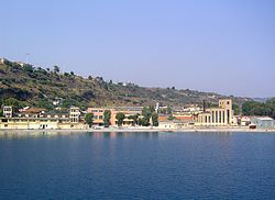
- Im Hafen von Egio
- Blick von Mertidi auf den Klokos
- Antikes Theater in Egira
Gemeindegliederung
| Gemeindebezirk | griechischer Name | Code | Fläche (km²) | Einwohner 2011 | Einwohner 2021 | Dimotikes Kinotites (Sg. Δημοτική Κοινότητα) | Lage |
|---|---|---|---|---|---|---|---|
| Egio | Δημοτική Ενότητα Αιγίου | 370201 | 151,341 | 26.523 | 25.795 | Egio, Valimitika, Dafnes, Digeliotika, Kouloura, Koumaris, Kounina, Mavriki, Melissia, Paraskevi, Pteri, Selinoundas, Temeni, Chatzis |  |
| Egira | Δημοτική Ενότητα Αιγείρας | 370202 | 103,252 | 2.626 | 2.293 | Egira, Eges, Ambelokipi, Vela, Exochi, Monastiri, Oasi, Perithori, Seliana, Sinevro, Chrysanthio |  |
| Akrata | Δημοτική Ενότητα Ακράτας | 370203 | 180,636 | 4.747 | 4.247 | Akrata, Agia Varvara, Ambelos, Valimi, Voutismos, Zarouchla, Kalamias, Krathio, Messorougi, Paralia Platanou, Peristera, Platanos, Provitsa, Syliveniotika |  |
| Diakopto | Δημοτική Ενότητα Διακοπτού | 370204 | 104,385 | 6.429 | 5.603 | Diakopto, Ano Diakopto, Eleonas, Eliki, Zachloritika, Katholiko, Kerynia, Mamousia, Nikoleika, Rizomylos, Rodia, Trapeza |  |
| Erineos | Δημοτική Ενότητα Ερινεού | 370205 | 99,768 | 3.236 | 2.890 | Ziria, Arravonitsa, Damakini, Kamares, Neos Erineos, Salmeniko |  |
| Symbolitia | Δημοτική Ενότητα Συμπολιτείας | 370206 | 85,762 | 6.311 | 6.162 | Rododafni, Agios Konstandinos, Alsos, Verino, Grekas, Grigoris, Dimitropoulo, Doukaneika, Krini Egialias, Lakka, Longos, Magiras, Myrovrysi, Nerantzies, Selianitika, Toumba |  |
| Gemeinde Egialia | 3702 | 725,144 | 49.872 | 46.990 | |||
Einzelnachweise
- ↑ Ergebnisse der Volkszählung 2021, Griechisches Statistisches Amt (ΕΛ.ΣΤΑΤ) ELSTAT (Excel-Dokument, 67,5 kB)
- ↑ William Smith: Dictionary of Greek and Roman Geography, London 1854 (Eintrag zu Achaia online)
Auf dieser Seite verwendete Medien
(c) Lencer, CC BY-SA 3.0
Positionskarte von Griechenland
Quadratische Plattkarte, N-S-Streckung 120 %. Geographische Begrenzung der Karte:
- N: 42.0° N
- S: 34.6° N
- W: 19.1° O
- O: 29.9° O
Nur ein blauer Punkt
Autor/Urheber: Pitichinaccio, Lizenz: CC BY 3.0
Lage der Gemeinde Egialia in der griechischen Region Westgriechenland (2011)
Autor/Urheber: Pitichinaccio, Lizenz: CC BY-SA 3.0
Position of Symbolitia Municipal Unit in Egilalia Municipality, Achaea Regional Unit, Peloponnese Region, Greece
Panoramic view of Selianitika and Longos
Autor/Urheber: Pitichinaccio, Lizenz: CC BY-SA 3.0
Position of Akrata Municipal Unit in Egilalia Municipality, Achaea Regional Unit, Peloponnese Region, Greece
Autor/Urheber: Pitichinaccio, Lizenz: CC BY-SA 3.0
Position of Egio Municipal Unit in Egilalia Municipality, Achaea Regional Unit, Peloponnese Region, Greece
Autor/Urheber: Pitichinaccio, Lizenz: CC BY-SA 3.0
Position of Erineos Municipal Unit in Egilalia Municipality, Achaea Regional Unit, Peloponnese Region, Greece
Autor/Urheber: Pitichinaccio, Lizenz: CC BY-SA 3.0
Der Berg Klokos von Westen (Mertidi); w:de:Egialia, Peloponnes, Griechenland
Autor/Urheber: Pitichinaccio, Lizenz: CC BY-SA 3.0
Position of Egira Municipal Unit in Egilalia Municipality, Achaea Regional Unit, Peloponnese Region, Greece
Autor/Urheber: Pitichinaccio, Lizenz: CC BY-SA 3.0
Position of Diakopto Municipal Unit in Egilalia Municipality, Achaea Regional Unit, Peloponnese Region, Greece


