Edwards Air Force Base
| Edwards Air Force Base | ||
|---|---|---|
 | ||
| Satellitenaufnahme der NASA | ||
| Kenndaten | ||
| ICAO-Code | KEDW | |
| IATA-Code | EDW | |
| Koordinaten | 34° 54′ 20″ N, 117° 53′ 1″ W | |
| Höhe über MSL | 702 m (2.303 ft) | |
| Verkehrsanbindung | ||
| Entfernung vom Stadtzentrum | 100 km nördlich von Los Angeles | |
| Straße | ||
| Basisdaten | ||
| Eröffnung | 1942 (als Air Base) | |
| Betreiber | ||
| Start- und Landebahnen | ||
| 04R/22L | 4576 m × 91 m Beton | |
| 04L/22R | 3658 m × 61 m Beton | |


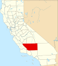
Die Edwards Air Force Base (IATA-Code: EDW, ICAO-Code: KEDW) ist eine Luftwaffenbasis der United States Air Force im Antelope Valley nahe Lancaster in Kalifornien, rund 100 Kilometer nördlich von Los Angeles. Mit ihren ausgedehnten Pisten auf dem ausgetrockneten See Rogers Dry Lake erlangte sie durch die dort durchgeführten Testflüge verschiedener Flugzeugtypen und als Landeplatz des Space Shuttles weltweit Berühmtheit.
Der rund 74 Quadratkilometer große Stützpunkt wird von der United States Air Force (USAF) und der NASA genutzt, die hier ihr Dryden Flight Research Center betreibt. Die USAF arbeitet in ihrem Air Force Flight Test Center (AFFTC) an Entwicklungen und Tests von bemannten und unbemannten Luftfahrzeugen, einschließlich deren Avionik. Die zweite bedeutende Einrichtung der US-Luftwaffe ist ihre Testpiloten-Schule (Test Pilot School).
Standard-Start- und Landebahn ist eine 4580 Meter lange Betonpiste (04R/22L), aber der völlig ebene und glatte Boden des umgebenden ausgetrockneten Sees erlaubt auch Landungen auf der gesamten Fläche. Zur Orientierung für die Piloten ist auf dem Seeboden eine Windrose mit 1220 Metern (4000 Fuß) Durchmesser aufgebracht. Zusätzlich sind rund 20 verschiedene Landebahnen markiert, die längste davon, Landebahn 17/35, misst 11.920 Meter × 275 Meter. Die Airbase diente etwa 50 Mal als Standardlandeplatz für die Shuttle-Missionen. Zuletzt landete hier im September 2009 die Discovery im Rahmen der Mission STS-128 auf dem Luftwaffenstützpunkt.
Auf der Edwards Air Base ist auch das Birk Flight Test Center angesiedelt, das aktuell (Stand: August 2011) den Test und Einflug der unbemannten Global-Hawk-Flugzeuge durchführt, bevor sie an den Nutzer abgegeben werden.
Nordwestlich ist der Mojave Air & Space Port gelegen.
Geschichte
Zunächst als Muroc Army Air Field und später als Muroc Army Air Force Base bezeichnet, wurde sie am 8. Dezember 1949 nach dem Testpiloten Glen Edwards benannt, der als Kopilot des Nurflügler-Prototyps Northrop YB-49 am 5. Juni 1948 an diesem Ort tödlich verunglückte.
Auf dem Rollfeld des Flugplatzes drehte die amerikanische Punk-Rock-Band NOFX mit Regisseur Gore Verbinski den Videoclip zum Titelsong ihres 1989 erschienenen Albums S&M Airlines.[1]
Weblinks
- Homepage der Edwards Air Force Base (englisch)
Einzelnachweise
- ↑ NOFX: Die Hepatitis-Badewanne und andere Storys. Autobiographie der Punk-Rock-Band NOFX verfasst mit Co-Autor Jeff Alulis, Verlag Edel (Optimal Media GmbH), Röbel/Müritz, 1. Auflage, Februar 2017. S. 140 f.
Auf dieser Seite verwendete Medien
Autor/Urheber: NordNordWest, Lizenz: CC BY 3.0
Positionskarte von Kalifornien, USA
Autor/Urheber: TUBS
Location map of the USA (Hawaii and Alaska shown in sidemaps).
Main map: EquiDistantConicProjection : Central parallel :
* N: 37.0° N
Central meridian :
* E: 96.0° W
Standard parallels:
* 1: 32.0° N
* 2: 42.0° N
Made with Natural Earth. Free vector and raster map data @ naturalearthdata.com.
Formulas for x and y:
x = 50.0 + 124.03149777329222 * ((1.9694462586094064-({{{2}}}* pi / 180))
      * sin(0.6010514667026994 * ({{{3}}} + 96) * pi / 180))
y = 50.0 + 1.6155950752393982 * 124.03149777329222 * 0.02613325650382181
      - 1.6155950752393982  * 124.03149777329222 *
     (1.3236744353715044  - (1.9694462586094064-({{{2}}}* pi / 180))
      * cos(0.6010514667026994 * ({{{3}}} + 96) * pi / 180))
Hawaii side map: Equirectangular projection, N/S stretching 107 %. Geographic limits of the map:
- N: 22.4° N
- S: 18.7° N
- W: 160.7° W
- E: 154.6° W
Alaska side map: Equirectangular projection, N/S stretching 210.0 %. Geographic limits of the map:
- N: 72.0° N
- S: 51.0° N
- W: 172.0° E
- E: 129.0° W
Flag of California. This version is designed to accurately depict the standard print of the bear as well as adhere to the official flag code regarding the size, position and proportion of the bear, the colors of the flag, and the position and size of the star.
Satellite image of the Edwards Air Force Base in California. Located at the Rogers Dry Lake in the Mojave Desert in California. On July 1, 2019, Operational Land Imager (OLI) on NASA's Landsat 8 acquired this image.
Service mark of the USAF
NASA/USGS 1m satellite image of Edwards Air Force Base, located in Mojave Desert, California.
Locator map showing Kern County — in central and southern California.
Vector image of a 24 in by 25 in (600 mm by 635 mm) California State Route shield. Colors are from [1] (Pantone Green 342), converted to RGB by [2]. The outside border has a width of 1 (1/16 in) and a color of black so it shows up; in reality, signs have no outside border.
750 mm × 600 mm (30 in × 24 in) U.S. Highway shield, made to the specifications of the 2004 edition of Standard Highway Signs. (Note that there is a missing "J" label on the left side of the diagram.) Uses the Roadgeek 2005 fonts. (United States law does not permit the copyrighting of typeface designs, and the fonts are meant to be copies of a U.S. Government-produced work anyway.)
US FAA airport diagram for KEDW (Edwards Air Force Base) Rogers Dry Lake in California, United States.
Vector image of a 24 in by 25 in (600 mm by 635 mm) California State Route shield. Colors are from [1] (Pantone Green 342), converted to RGB by [2]. The outside border has a width of 1 (1/16 in) and a color of black so it shows up; in reality, signs have no outside border.


