Duncansby Head
Duncansby Head ist die Nordostspitze von Schottland, nahe der Ortschaft John o’ Groats. Auf den steilen Klippen steht ein 1924 errichteter Leuchtturm. Spektakulär ist Duncansby Head vor allem wegen seiner zerklüfteten Felsformationen und Felsnadeln, den so genannten Duncansby Stacks. In den Klippen nisten viele seltene Seevögel, darunter auch die Papageitaucher.
Muckle Skerry ist eine Insel der Orkney sieben Kilometer nordöstlich von Duncansby Head.

Karte

Ordnance-Survey-Kartenblatt (1959)
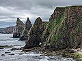
Duncansby Stacks

Der nordöstlichste Punkt des schottischen Festlands – Blickrichtung Norden
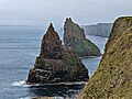
Blickrichtung Süden – Zwei Stacks

Der Leuchtturm Duncansby Head
Weblinks
Commons: Duncansby Head – Sammlung von Bildern, Videos und Audiodateien
- Bilder und Information zum Leuchtturm auf Fredis Schottland-Seiten
Koordinaten: 58° 38′ 39″ N, 3° 1′ 27″ W
Auf dieser Seite verwendete Medien

Duncansby Head 16.jpg
Autor/Urheber: PaulT (Gunther Tschuch), Lizenz: CC BY-SA 4.0
Duncansby Head, Caithness, Scotland
Autor/Urheber: PaulT (Gunther Tschuch), Lizenz: CC BY-SA 4.0
Duncansby Head, Caithness, Scotland

Duncansby Head 09.jpg
Autor/Urheber: PaulT (Gunther Tschuch), Lizenz: CC BY-SA 4.0
Duncansby Head, Caithness, Scotland
Autor/Urheber: PaulT (Gunther Tschuch), Lizenz: CC BY-SA 4.0
Duncansby Head, Caithness, Scotland

Ordnance Survey One-Inch Sheet 7 Pentland Firth, Published 1959.jpg
OS map covering the southern part of the Orkney Islands, the Pentland Firth, and the adjacent coast of NE Scotland, at a scale of 1:63,360 or one inch to one mile.
OS map covering the southern part of the Orkney Islands, the Pentland Firth, and the adjacent coast of NE Scotland, at a scale of 1:63,360 or one inch to one mile.

DH1-Sco.jpg
Autor/Urheber: McKarri, Hamburg, Germany, Lizenz: CC BY-SA 2.0 de
Duncansby Head - nordöstlichster Festlandpunkt in Schottland
Autor/Urheber: McKarri, Hamburg, Germany, Lizenz: CC BY-SA 2.0 de
Duncansby Head - nordöstlichster Festlandpunkt in Schottland

Duncansby Head 07.jpg
Autor/Urheber: PaulT (Gunther Tschuch), Lizenz: CC BY-SA 4.0
Duncansby Head, Caithness, Scotland
Autor/Urheber: PaulT (Gunther Tschuch), Lizenz: CC BY-SA 4.0
Duncansby Head, Caithness, Scotland

PentlandFirthMap.png
(c) Kelisi aus der englischsprachigen Wikipedia, CC BY-SA 3.0
A map of the Pentland Firth, northern Scotland, showing various towns and villages on the British mainland and in Orkney, as well as physical features, including islands in the Firth. This map's source is here, with the uploader's modifications, and the GMT homepage says that the tools are released under the GNU General Public License.