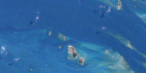
Duncan-Inseln
| Duncan-Inseln | |
|---|---|
| Landsat-Bild der Gruppe | |
| Gewässer | Pazifischer Ozean |
| Archipel | Torres-Strait-Inseln |
| Geographische Lage | 10° 14′ S, 142° 5′ O |
| Anzahl der Inseln | ca. 15 |
| Gesamte Landfläche | 0,8 km² |
| Einwohner | unbewohnt |
Die Duncan-Inseln sind eine australische Inselgruppe zwischen Australien und Neuguinea. Sie liegen im Westen des Archipels der Torres-Strait-Inseln, etwa 14 km westlich von Moa Island.
Es handelt sich um einige sehr kleine flache Felsinseln; alle Inseln sind unbewohnt.
Zu der Gruppe zählen u. a. folgende Inselchen:
![]() Karte mit allen Koordinaten: OSM | WikiMap
Karte mit allen Koordinaten: OSM | WikiMap
| Inselname | Fläche (km²), ca. | Geokoordinaten |
|---|---|---|
| Ngurtai | 0,03 | 10° 13′ S, 142° 03′ O |
| Quoin Island | 0,06 | 10° 13′ S, 142° 04′ O |
| Meth Island | 0,04 | 10° 14′ S, 142° 04′ O |
| Wilson Island | 0,40 | 10° 14′ S, 142° 05′ O |
| Kanig Island | 0,26 | 10° 15′ S, 142° 05′ O |
Verwaltungstechnisch gehören die Duncan-Inseln zu den Western Islands, einer Inselregion im Verwaltungsbezirk Torres Shire von Queensland.
Siehe auch
Auf dieser Seite verwendete Medien
Duncan Islands, Western Torres Strait Islands, Queensland, Australia. Near right corner of the picture shows Green Islet.
(c) Kelisi aus der englischsprachigen Wikipedia, CC BY-SA 3.0
A map of the Torres Strait Islands. I have endeavoured to use native names wherever I could find them. If you can suggest ways in which this map could be made more up to date, don't hesitate to leave me a message to that effect.
This map's source is here, with the uploader's modifications, and the GMT homepage says that the tools are released under the GNU General Public License.


