Dry Tortugas
| Dry Tortugas | ||
|---|---|---|
 | ||
| Gewässer | Golf von Mexiko | |
| Archipel | Florida Keys | |
| Geographische Lage | 24° 38′ N, 82° 52′ W | |
| Anzahl der Inseln | 7 | |
| Hauptinsel | Garden Key | |
| Gesamte Landfläche | 58,4 ha | |
| Einwohner | unbewohnt | |
 | ||
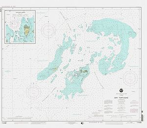
Die Dry Tortugas sind eine zu Florida gehörende, unbewohnte Inselgruppe im Golf von Mexiko. Sie stellen die äußerste, westlichste Gruppe der Florida Keys dar.
Die Inseln wurden 1513 von Juan Ponce de León entdeckt, der ihnen den Namen „Tortugas“ gab, nach den zahlreichen dort beobachteten Meeresschildkröten. Der Zuname „Dry“ (= trocken) wurde später hinzugefügt, um das Fehlen von Trinkwasser anzuzeigen.
Die Dry Tortugas bestehen aus sieben kleinen Inseln (Keys) mit einer Gesamtfläche von 584.000 m² (0,584 km²), einigen Sandbänken sowie unzähligen Korallenriffen.
Die Inseln sind:
- 260.000 m²: Loggerhead Key, größte und mit bis 3 m Höhe höchste Insel. Auf ihr steht das Dry Tortugas Lighthouse (46 Meter hoch).
- 170.000 m²: Garden Key, zweitgrößte Insel, mit Fort Jefferson und dem Garden Key Lighthouse (20 Meter hoch).
- 120.000 m²: Bush Key
- 16.000 m²: East Key
- 8.000 m²: Long Key
- 6.000 m²: Middle Key
- 4.000 m²: Hospital Key
Ehemalige Inseln, heute Sandbänke, sind:
- Southwest Key, 1875 versunken
- Bird Key, 1935 versunken
- North Key, 1875 versunken
- Northeast Key, 1875 versunken
Die Inselgruppe steht bereits seit 1908 unter Naturschutz und wurde 1992 mitsamt den sie umgebenden Gewässern zum Dry-Tortugas-Nationalpark erhoben.
Weblinks
Auf dieser Seite verwendete Medien
Autor/Urheber: Eric Gaba (Sting - fr:Sting), Lizenz: CC BY-SA 3.0
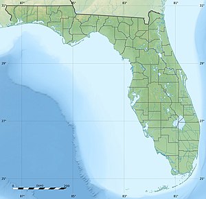
Blank physical map of the State of Florida, USA, for geo-location purpose, with counties boundaries.
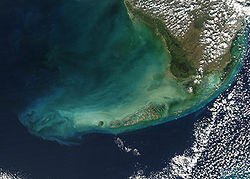
Turbid waters surround southern Florida and the Florida Keys in this true-color Moderate Resolution Imaging Spectroradiometer (MODIS) image taken by the Aqua satellite on December 2, 2003. Clouds of milky blue, green, and tan sediments and microscopic marine organisms (like phytoplankton and algae) discolor the water in the Gulf of Mexico north of the Keys, but end abruptly in the deeper water of the Straits of Florida. The water north of the Keys is relatively shallow, so sediments are a likely cause of the discoloration—rough waters can churn up the mud from the sea floor, which then clouds the water. But in the deeper water south of the Keys, sediment on the sea floor is much harder to disturb, which keeps the water clearer.
The Keys are a collection of islands, islets, and reefs stretching from Virginia Key to the Dry Tortugas, a distance of about 309 kilometers (192 miles). They're made mostly of limestone and coral, and are known for their variety of wildlife, subtropical vegetation, and spectacular diving. Most of the islands are connected to the mainland via the Overseas Highway, making this a popular and easily-accessible destination.
However, popularity can be a double-edged sword. On the one hand, tourism is one of the economic mainstays of the region, and helps increase public awareness of how fragile this ecosystem is. But on the other hand, those same tourists and their activities can hurt the ecosystem by introducing pollutants and causing physical damage to fragile reefs.


