Droga krajowa 60
| Droga krajowa 60 in Polen | ||||||||||||||||||||||||||||||||||||||||||||||||||||||||||||||||||||||||||||||||||||||||||||||||||||||||||||||||||||||||||||||||||||||||||||||||||||||||||||||||||||||||||||||||||||||||
 | ||||||||||||||||||||||||||||||||||||||||||||||||||||||||||||||||||||||||||||||||||||||||||||||||||||||||||||||||||||||||||||||||||||||||||||||||||||||||||||||||||||||||||||||||||||||||
| Karte | ||||||||||||||||||||||||||||||||||||||||||||||||||||||||||||||||||||||||||||||||||||||||||||||||||||||||||||||||||||||||||||||||||||||||||||||||||||||||||||||||||||||||||||||||||||||||
 | ||||||||||||||||||||||||||||||||||||||||||||||||||||||||||||||||||||||||||||||||||||||||||||||||||||||||||||||||||||||||||||||||||||||||||||||||||||||||||||||||||||||||||||||||||||||||
| Basisdaten | ||||||||||||||||||||||||||||||||||||||||||||||||||||||||||||||||||||||||||||||||||||||||||||||||||||||||||||||||||||||||||||||||||||||||||||||||||||||||||||||||||||||||||||||||||||||||
| Betreiber: | ||||||||||||||||||||||||||||||||||||||||||||||||||||||||||||||||||||||||||||||||||||||||||||||||||||||||||||||||||||||||||||||||||||||||||||||||||||||||||||||||||||||||||||||||||||||||
| Straßenbeginn: | 52° 4′ 48″ N, 19° 10′ 12″ O | |||||||||||||||||||||||||||||||||||||||||||||||||||||||||||||||||||||||||||||||||||||||||||||||||||||||||||||||||||||||||||||||||||||||||||||||||||||||||||||||||||||||||||||||||||||||
| Straßenende: | 52° 48′ 0″ N, 21° 52′ 12″ O | |||||||||||||||||||||||||||||||||||||||||||||||||||||||||||||||||||||||||||||||||||||||||||||||||||||||||||||||||||||||||||||||||||||||||||||||||||||||||||||||||||||||||||||||||||||||
| Gesamtlänge: | 244 km | |||||||||||||||||||||||||||||||||||||||||||||||||||||||||||||||||||||||||||||||||||||||||||||||||||||||||||||||||||||||||||||||||||||||||||||||||||||||||||||||||||||||||||||||||||||||
 | ||||||||||||||||||||||||||||||||||||||||||||||||||||||||||||||||||||||||||||||||||||||||||||||||||||||||||||||||||||||||||||||||||||||||||||||||||||||||||||||||||||||||||||||||||||||||
| Die DK60 in Gostynin | ||||||||||||||||||||||||||||||||||||||||||||||||||||||||||||||||||||||||||||||||||||||||||||||||||||||||||||||||||||||||||||||||||||||||||||||||||||||||||||||||||||||||||||||||||||||||
Straßenverlauf
| ||||||||||||||||||||||||||||||||||||||||||||||||||||||||||||||||||||||||||||||||||||||||||||||||||||||||||||||||||||||||||||||||||||||||||||||||||||||||||||||||||||||||||||||||||||||||


Die Droga krajowa 60 (DK60) ist eine Landesstraße in Polen.
Verlauf
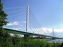
Die Straße beginnt in Topola-Królewska rund 2 Kilometer nördlich von Łęczyca an der DK91 und verläuft zunächst in nordnordöstlicher Richtung über Kutno, wo die DK2 gekreuzt wird, über die Anschlussstelle Sójki der Autostrada A1 zur Weichsel, die bei der Stadt Płock erreicht und gemeinsam mit der Droga krajowa 62 auf der Brücke Most Solidarności überquert wird. Die Straße verläuft weiter durch das Zentrum von Płock und von dort nach Nordosten über Drobin (Kreuzung mit der DK10), Raciąż, Glinojeck (Kreuzung mit der Droga ekspresowa S7), überquert den Fluss Wkra (deutsche Bezeichnung im Oberlauf: Neide) und erreicht weiter im Osten Ciechanów, wo von Süden kommend die DK50 einmündend endet. In Maków Mazowiecki kreuzt die DK57, in Różan die DK61. Die DK60 setzt sich nun in ostsüdöstlicher Richtung bis Ostrów Mazowiecka fort, wo sie an der Droga ekspresowa S8 (Europastraße 67) endet.
Die Länge der Straße beträgt rund 244 Kilometer.
Wichtige Ortschaften an der Strecke
Woiwodschaft Łódź (województwo łódzkie):
Woiwodschaft Masowien (województwo mazowieckie):
Siehe auch
Weblinks
- Website der GDDKiA (polnisch)
- Website des Programms Drogi Zaufania (polnisch)
Auf dieser Seite verwendete Medien
(c) OOjs UI Team and other contributors, MIT
An icon from the OOjs UI MediaWiki lib.
Wellenlinie als Gewässersymbol für die Formatvorlage Autobahn
Sign of DW 567 with oficial font Drogowskaz and adequate dimensions.
Sign of DK50 with official font Drogowskaz.
Autokreuzung (Icon) in grün.
Sign of E 67 with oficial font Drogowskaz
Sign of DW 568 with oficial font Drogowskaz and adequate dimensions.
Sign of DW 626 with oficial font Drogowskaz and adequate dimensions.
Autor/Urheber: Radosław Drożdżewski (Zwiadowca21), Lizenz: CC BY-SA 1.0
Droga krajowa nr 60 w Bielsku.
Sign of DW 575 with oficial font Drogowskaz and adequate dimensions.
Sign of E75 with oficial font Drogowskaz
Sign of DK 60 with oficial font Drogowskaz
Sign of DW 617 with oficial font Drogowskaz and adequate dimensions.
Autor/Urheber: odder, Lizenz: CC BY-SA 2.5
Poland, road sign D-42: "built-up area".
Sign of DK 62 with oficial font Drogowskaz
Sign of DW 540 with oficial font Drogowskaz and adequate dimensions.
Sign of DW 577 with oficial font Drogowskaz and adequate dimensions.
Sign of DW 573 with oficial font Drogowskaz and adequate dimensions.
Polish sign of route E77
Sign of DW 560 with oficial font Drogowskaz and adequate dimensions.
Autor/Urheber: Pilgerobst, Miko101, Lizenz: CC BY-SA 2.0
Karte der polnischen Droga krajowa 60
Sign of DK 53 with oficial font Drogowskaz
roundabout-icon in green
Znak E-17a: miejscowość.
Sign of DW 615 with oficial font Drogowskaz and adequate dimensions.
Sign of expressway S8 with oficial font Drogowskaz
Angepasst: Umfahrung
Sign of expressway S7 with oficial font Drogowskaz
Sign of motorway A1 with original font Drogowskaz
Sign of DW 702 with oficial font Drogowskaz and adequate dimensions.
Sign of DW 618 with oficial font Drogowskaz and adequate dimensions.
Sign of DK10 with oficial font Drogowskaz
Sign of DK 61 with oficial font Drogowskaz
Sign of DK92 with oficial font Drogowskaz
Autor/Urheber: Rommullus, Lizenz: CC BY-SA 4.0
The Solidarity Bridge in Płock, Poland
Autor/Urheber:
unbekannt
, Lizenz: LogoLogo der polnischen Gesellschaft GDDKiA (Generalna Dyrekcja Dróg Krajowych i Autostrad), den Betreiber der Autobahnen, Schnellstraßen sowie der Nationalstraßen
Polish sign of DK91
Sign of DW 559 with oficial font Drogowskaz and adequate dimensions.
Sign of DK 57 with oficial font Drogowskaz
Znak E-18a: koniec miejscowości.


