Drexel Heights
| Drexel Heights | |
|---|---|
 | |
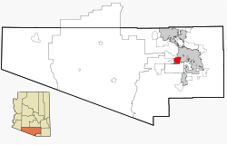
| Lage im County und in Arizona | |
| Basisdaten | |
| Staat: | Vereinigte Staaten |
| Bundesstaat: | Arizona |
| County: | Pima County |
| Koordinaten: | 32° 8′ N, 111° 2′ W |
| Zeitzone: | Mountain Standard Time (UTC−7) |
| Einwohner: | 27.523 (Stand: 2020) |
| Haushalte: | 9.684 (Stand: 2020) |
| Fläche: | 51,0 km2 (ca. 20 mi²) davon 51,0 km2 (ca. 20 mi²) Land |
| Bevölkerungsdichte: | 540 Einwohner je km2 |
| Höhe: | 770 m |
| FIPS: | 04-20540 |
| GNIS-ID: | 0025237 |
Drexel Heights ist ein Census-designated place im Pima County im US-Bundesstaat Arizona. Das U.S. Census Bureau hat bei der Volkszählung 2020 eine Einwohnerzahl von 27.523[1] ermittelt.
Drexel Heights hat eine Fläche von 51,0 km². Im Osten der Stadt verläuft die Interstate 19 und im Norden die Arizona State Route 86.
Weblinks
Einzelnachweise
- ↑ Explore Census Data Drexel Heights CDP, Arizona. Abgerufen am 24. Oktober 2022.
Auf dieser Seite verwendete Medien
Autor/Urheber: Davidg221, Lizenz: CC0
A rainbow appearing after a monsoon in Drexel Heights, Arizona, USA.
Autor/Urheber: Ixnayonthetimmay, Lizenz: CC BY-SA 3.0
This map shows the incorporated areas and unincorporated areas in Pima County, Arizona. Incorporated cities are shown in gray and data for their borders and locations are based on the 2000/2030 PAG Transportation Analysis Zone Map. Drexel Heights is highlighted in red. Information for unincorporated locations and borders are based on the Census 2000 Pima County Tract Outline Index Map (PDF). I created this map in en:Inkscape.


