Distrikt Tuaran
| Distrikt Tuaran | |
|---|---|
| Koordinaten | 6° 11′ N, 116° 14′ O |
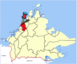
 Lage von Distrikt und Stadt Tuaran | |
| Basisdaten | |
| Staat | Malaysia |
| Sabah | |
| ISO 3166-2 | MY-12 |
| Fläche | 1166 km² |
| Einwohner | 135.665 (2020[1]) |
| Dichte | 116,4 Ew./km² |
| Website | www.sabah.gov.my/pd.trn/ |
| Politik | |
| District Officer | Madiyem Layapan |
Photo by CEphoto, Uwe Aranas or alternatively © CEphoto, Uwe Aranas, CC BY-SA 3.0 District Office Tuaran (Pejabat Daerah Tuaran) | |

Der Distrikt Tuaran ist ein Verwaltungsbezirk im malaysischen Bundesstaat Sabah. Verwaltungssitz ist die Stadt Tuaran. Der Distrikt Tuaran ist Teil des Gebietes West Coast Division, zu dem die Distrikte Kota Kinabalu, Ranau, Kota Belud, Tuaran, Penampang, Putatan und Papar gehören.
Demographie
Tuaran hat 135.665 Einwohner (Stand: 2020). Die Bevölkerung des Distrikts Tuaran betrug laut der letzten Zählung im Jahr 2010 102.411 Einwohner[2] und besteht etwa zu gleichen Teilen aus Dusun (42 %) und Bajau (34 %) sowie einem beträchtlichen Anteil an Chinesen (4 %) und Malaien (4 %). Wie in vielen anderen Distrikten Sabahs gibt es auch hier eine große Anzahl illegaler Immigranten aus den nahegelegenen Philippinen, vor allem aus Sulu und Mindanao, die in der Bevölkerungsstatistik nicht verzeichnet sind.
Verwaltungssitz
Verwaltungssitz des Distrikts ist die Stadt Tuaran.
Gliederung des Distrikts
Der Distrikt ist in drei Unterbezirke oder Regionen (kawasan) aufgeteilt: Sulaman, Kiulu und Tamparuli. Diesen sind wiederum fünf oder sechs Gemeindeverwaltungen (mukim) zugeordnet:
- Kawasan SULAMAN
- Mukim Berungis
- Mukim Mengkabong
- Mukim Tambalang
- Mukim Serusop
- Mukim Indai
- Kawasan KIULU
- Mukim Ulu
- Mukim Tengah
- Mukim Lembah
- Mukim Pantai
- Mukim Nabalu
- Mukim Pekan
- Kawasan TAMPARULI
- Mukim Tamparuli
- Mukim Tenghilan
- Mukim Topokon
- Mukim Mangkaladoi
- Mukim Tuaran Bandar
Liste der District Officers in Tuaran
| Name | Im Amt ab | Im Amt bis |
|---|---|---|
| J.P. Rutherford | 1949 | |
| H. George | 1949 | 1949 |
| J.P.C. Burbroke | 1949 | 1951 |
| E.A. Pascoe | 1951 | 1952 |
| I.C. Peck | 1952 | 1953 |
| G.F Douglas | 1953 | 1954 |
| H. George | 1955 | 1955 |
| M. Pike | 1955 | 1956 |
| Leong Ah Koon | 1956 | 1958 |
| D.W. Eisenhauer | 1958 | 1959 |
| John D. Dusing | 1959 | 1960 |
| J.A.G. Roberts | 1960 | 1962 |
| Peter L. Regis | 1964 | 1964 |
| Goh Bee Leng – Memangku | 1964 | 1964 |
| Peter L. Regis | 1964 | 1964 |
| Paul Lai Kui Seong | 1964 | 1967 |
| Dzulkifli Abdul Hamid | 1967 | |
| Dato Bistari Dato Jinurain | 1967 | 1968 |
| A.O. Pangiran Rauf | 1968 | 1970 |
| Mohd. Yusuf Yahya | 1970 | 1973 |
| Hj. Pauzi Kou | 1973 | 1974 |
| Hj. Abdullah Hj. Mohd. Arshad | 1974 | 1974 |
| Hj. Shamsudin Liew Syn Su | 1974 | 1975 |
| S. Mohd. Abdillah | 1975 | 1976 |
| Mohd. Zulfikar | 1976 | 1978 |
| Patrick Micheal | 1978 | 1980 |
| Masidi Manjun | 1980 | 1982 |
| Yahya Ahmad Shah | 1982 | |
| Abdul Rahman LO | 1985 | |
| Jahid Jahim | 1982 | 1988 |
| Ariffin Gadait | 1989 | 1992 |
| Udin Dullah | 1992 | 1996 |
| Hj. Uda Hj. Sulai | 1996 | 1997 |
| Awang Shamsi Hj. Jamih | 1997 | 2010 |
| Madiyem Layapan | 1. Sept. 2010 | amtierend |
Siehe auch
Literatur
- Owen Rutter: British North Borneo – An Account of its History, Ressources and Native Tribes. Constable & Company, London 1922; archive.org.
- W. H. Treacher: British Borneo – Sketches of Brunai, Sarawak, Labuan and North Borneo. Government print department, Singapore 1891; archive.org.
- K. G. Tregonning: A History Of Modern Sabah (North Borneo 1881–1963). 2. Ausgabe. University of Malaya Press, Kuala Lumpur 1965, Reprint 1967; archive.org.
Einzelnachweise
- ↑ Jadual 2-6 - Penduduk, IR dan TK mengikut Negeri 2020. In: Jadual 2-6 - Penduduk, IR dan TK mengikut Negeri 2020. Department of Statistics Malaysia, 2020, abgerufen am 18. März 2022 (englisch, malaiisch).
- ↑ Population Distribution by Local Authority Areas and Mukims, 2010. (Memento des vom 27. Februar 2012 im Internet Archive; PDF) Info: Der Archivlink wurde automatisch eingesetzt und noch nicht geprüft. Bitte prüfe Original- und Archivlink gemäß Anleitung und entferne dann diesen Hinweis. (PDF; 368 kB) Census 2010, S. 369.
Auf dieser Seite verwendete Medien
Flag of the Malaysian state Sabah. Based on a GIF from a government website, colors from a photo. Drawn by Mysid. The flag was adopted September 16, 1988.
- The mountain on the left is Mount Kinabalu.
Per the Constitution of the State of Sabah:
"The State Flag is in a rectangular shape and is in the proportion of 1:2. The canton which extends at the head half way to the fly and 2/3 at the hoist to the foot is in Icicle Blue (C1T9) as the background to a graphic silhouette of Mount Kinabalu which is in Royal Blue (B10) positioned at ¼ of the height of the canton from end to end. The fly of the flag is divided equally into three bands of colours the foot division of which extends right to the hoist. The top band is in Zircon Blue (C5T5) the second band is in white and the third band is in Chili Red (S6R4)."Photo by CEphoto, Uwe Aranas or alternatively © CEphoto, Uwe Aranas, CC BY-SA 3.0
District Office Tuaran (Pejabat Daerah Tuaran) - Office of the District Officer
Autor/Urheber: CEphoto, Uwe Aranas, Lizenz: CC BY-SA 3.0
District Office Tuaran (Pejabat Daerah Tuaran)
Autor/Urheber: Cccefalon; Pushpin: McSush, Lizenz: CC BY-SA 3.0
Sabah: Location map of District and Town Tuaran


