Discovery Bay (Südliche Shetlandinseln)
| Discovery Bay | ||
|---|---|---|
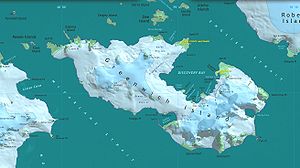
 Karte von Greenwich Island mit der Discovery Bay | ||
| Gewässer | English Strait | |
| Landmasse | Greenwich Island, Südliche Shetlandinseln | |
| Geographische Lage | 62° 28′ 58,8″ S, 59° 42′ 57,6″ W | |
| Inseln | Basso Island, Bonert Rock, Canales Island, Islotes Catalán, Coloma Island, Cruz Rock, Dovizio Rock, Fuente Rock, Honores Rock, Joliette Rock, Skarmeta Rocks, Tenorio Rock, Valdebenito Rock, Vidal Rock | |
| Zuflüsse | Fuerza-Aérea-Gletscher, Jorquera-Gletscher, Traub-Gletscher | |
Die Discovery Bay (englisch für Entdeckungsbucht, in Chile Bahía Chile) ist eine Bucht von 5 km Länge und 3 km Breite an der Ostküste von Greenwich Island im Archipel der subantarktischen Inselgruppe Südliche Shetlandinseln.
Bekannt ist die Bucht durch Robbenjäger mindestens seit 1821. Teilnehmer der britischen Discovery Investigations kartierten und benannten sie im Jahr 1935.
Weblinks
- Discovery Bay. In: Geographic Names Information System. United States Geological Survey, United States Department of the Interior, archiviert vom (englisch).
- Discovery Bay auf geographic.org (englisch)
Auf dieser Seite verwendete Medien
Autor/Urheber: NordNordWest, Lizenz: CC BY-SA 3.0
Positionskarte der Südlichen Shetlandinseln
Autor/Urheber: Antarctic Place-names Commission of Bulgaria, Lizenz: GPL
L.L. Ivanov et al., Antarctica: Livingston Island, South Shetland Islands (from English Strait to Morton Strait, with illustrations and ice-cover distribution), 1:100000 scale topographic map, Antarctic Place-names Commission of Bulgaria, Sofia, 2005 (Fragment) Fragment released in the public domain by the Antarctic Place-names Commission of Bulgaria.


