Diamantino (Mato Grosso)
| Município de Diamantino Diamantino | |||
|---|---|---|---|
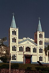
 Catedral de Nossa Senhora da Conceição | |||
| Koordinaten | 14° 25′ S, 56° 27′ W | ||
 Lage des Munizips im Bundesstaat Mato Grosso Lage des Munizips im Bundesstaat Mato Grosso | |||
| Symbole | |||
| |||
| Gründung | 18. September 1728 Siedlungskern (295 Jahre) | ||
| Basisdaten | |||
| Staat | Brasilien | ||
| Bundesstaat | Mato Grosso | ||
| ISO 3166-2 | BR-MT | ||
| Höhe | 269 m | ||
| Klima | tropisch, Aw[1] | ||
| Fläche | 8.191,7 km² | ||
| Einwohner | 20.341 (2010) | ||
| Dichte | 2,5 Ew./km² | ||
| Schätzung | 22.178 (1. Juli 2020) | ||
| Gemeindecode | IBGE: 5103502 | ||
| Postleitzahl | 78400-000 | ||
| Telefonvorwahl | (+55) 65 | ||
| Zeitzone | UTC−4 | ||
| Website | diamantino.mt (brasilianisches Portugiesisch) | ||
| Politik | |||
| Stadtpräfekt | Eduardo Capistrano[2] (2017–2020) | ||
| Partei | PDT | ||
| Wirtschaft | |||
| BIP | 1.957.070 Tsd. R$ 91.907 R$ pro Kopf (2017) | ||
| HDI | 0,718 (2010) | ||
Diamantino, amtlich portugiesisch Município de Diamantino, ist eine Gemeinde im Bundesstaat Mato Grosso. Sie liegt rund 200 km Wegstrecke von der Hauptstadt Cuiabá entfernt. Die Bevölkerung wurde zum 1. Juli 2020 auf 22.178 Einwohner geschätzt, die Diamantinenser (diamantinenses) genannt werden und auf einer großen Gemeindefläche von rund 8191,7 km² leben.[3] Die Bevölkerungsdichte der gesamten Gemeinde beträgt 2,5 Personen pro Quadratkilometer.
Toponymie
Benannt ist der Ort wegen der Diamantfunde im 18. Jahrhundert.[4]
Geographie
Umliegende Gemeinden sind Alto Paraguai, Nortelândia, Nova Maringá, São José do Rio Claro, Nova Mutum, Nobres, Campo Novo do Parecis, Tangará da Serra und Nova Marilândia.
Das Biom ist amazonisch (Amazônia) und brasilianischer Cerrado.
Klima
Die Gemeinde hat tropisches Klima, Aw nach der Klimaklassifikation nach Köppen und Geiger. Die Durchschnittstemperatur ist 25,8 °C. Die durchschnittliche Niederschlagsmenge liegt bei 1705 mm im Jahr. Der Südsommer hat höhere Niederschläge als der Südwinter.[1]
Bevölkerungsentwicklung
| Jahr | Einwohner | Stadt | Land |
|---|---|---|---|
| 1991 | 14.827 | 12.556 | 2.271 |
| 2000 | 18.048 | 14.316 | 3.732 |
| 2010 | 20.341 | 15.895 | 4.446 |
| 2020 | 22.178 | ? | ? |
| Die Darstellung von Grafiken ist aktuell auf Grund eines Sicherheitsproblems deaktiviert. | |||
Quelle: IBGE (2011)[5]
Bilder

Verkehrsanbindung
| Straßenverbindungen |
| Flugverbindungen |
Söhne und Töchter der Gemeinde
- José Barnabé de Mesquita (1855–1892), Politiker, Autor
- Breno Caldeira (* 1946), Schriftsteller
- Gilmar Mendes (* 1955), oberster Bundesrichter
Weblinks
- Website der Stadtpräfektur, Prefeitura Municipal (brasilianisches Portugiesisch)
- Atlas do Desenvolvimento Humano no Brasil: Diamantino, MT, sozialstatistische Angaben, Stand 2010 (brasilianisches Portugiesisch)
- Website des Stadtrats, Câmara Municipal (brasilianisches Portugiesisch)
Einzelnachweise
- ↑ a b Klima Diamantino: Wetter, Klimatabelle & Klimadiagramm. In: de.climate-data.org. Abgerufen am 19. September 2020.
- ↑ Eduardo Capistrano 12 (Prefeito). In: todapolitica.com. Eleições 2016, abgerufen am 19. September 2020 (brasilianisches Portugiesisch).
- ↑ Diamantino – Panorama. IBGE, abgerufen am 19. September 2020 (brasilianisches Portugiesisch).
- ↑ História. In: gov.br. Prefeitura de Diamantino, abgerufen am 19. September 2020 (brasilianisches Portugiesisch).
- ↑ Atlas do Desenvolvimento Humano no Brasil: Diamantino, MT (Seite nicht mehr abrufbar, festgestellt im Oktober 2022. Suche in Webarchiven) Info: Der Link wurde automatisch als defekt markiert. Bitte prüfe den Link gemäß Anleitung und entferne dann diesen Hinweis.. Abgerufen am 19. September 2020 (brasilianisches Portugiesisch).
Auf dieser Seite verwendete Medien
Autor/Urheber:
- Brazil_location_map.svg: NordNordWest
- derivative work: Виктор В (talk)
Location map of Brazil
Autor/Urheber: Raphael Lorenzeto de Abreu, Lizenz: CC BY 2.5
Map locator of Mato Grosso's Diamantino city.
Autobahnsymbol gerade (Für E-Straßen)
Flag of Diamantino, Mato Grosso, Brazil.
600 mm by 600 mm (24 in by 24 in) Massachusetts Route shield, made to the specifications of the 1996 edition of Construction and Traffic Standard Details (sign M1-5). Uses the Roadgeek 2005 fonts. (United States law does not permit the copyrighting of typeface designs, and the fonts are meant to be copies of a U.S. Government-produced work anyway.) The outside border has a width of 1 (1 mm) and a color of black so it shows up; in reality, signs have no outside border. The specs actually do not show the curve on the outside border, instead making it a perfect square, but all signs I have seen round the corners.
Autor/Urheber: Mateus Hidalgo, Lizenz: CC BY-SA 2.0
Antiga Catedral de Nossa Senhora da Conceição, Diamantino.
Foto com correção de perspectiva.
Pentax K1000 - Pentax 50mm f/2.0
Filme Fuji Superia 400600 mm by 600 mm (24 in by 24 in) Massachusetts Route shield, made to the specifications of the 1996 edition of Construction and Traffic Standard Details (sign M1-5). Uses the Roadgeek 2005 fonts. (United States law does not permit the copyrighting of typeface designs, and the fonts are meant to be copies of a U.S. Government-produced work anyway.) The outside border has a width of 1 (1 mm) and a color of black so it shows up; in reality, signs have no outside border. The specs actually do not show the curve on the outside border, instead making it a perfect square, but all signs I have seen round the corners.
Imagem do Fundo Obra Rara.
Autor/Urheber: User:Ahoerstemeier, Lizenz: CC BY-SA 3.0
Map of Brazil highlighting Mato Grosso
A depiction of an MUTCD-standard Airport road sign. This would normally be used with directional road signs to indicate that a route leads to an airport.


