Diamantina Fracture Zone
Die Diamantina Fracture Zone (wörtlich übersetzt Diamantina-Bruchzone) ist eine bis 7100 m tiefe Schichtstufe im Südostindischen Becken des Indischen Ozeans. Fälschlich wird sie manchmal als Diamantinagraben (englisch Diamantina trench) bezeichnet.[1][2][3]
Geographie


Laut General Bathymetric Chart of the Oceans (GEBCO) beginnt die eigentliche, etwa 550 km lange Diamantina Fracture Zone im Westen (33° 57′ S, 101° 27′ O) am süd-östlichen Ende der Broken Ridge und erstreckt sich im Osten (36° 12′ S, 106° 38′ O) bis südlich des Perth-Beckens bis zur Südkante des Naturaliste Plateau.[3] Nördlich davon liegt das östliche Ende (32° 40′ S, 102° 30′ O) des Diamantina Escarpment, dessen westliches Ende (31° 0′ S, 90° 0′ O) am Neunzig-Grad-Ost-Rücken liegt.[3] Der meistens 10°, teilweise aber 35° steile Hang des Escarpments fällt über 5100 m von der südlich des Wharton-Beckens gelegenen Broken Ridge (634 m) nach Süden zum Boden des Diamantinagrabens ab (5800 m), der geomorphologisch wegen seines flachen Bodens als Trogtal zu bezeichnen ist.[4] Teilweise werden auch östliche Ausläufer südlich von Australien zur Diamantina Fracture Zone hinzugezählt (laut GEBCO Diamantina (East) Zone, 37° 30′ S, 128° 0′ O),[3] wodurch sie ins australische Meeresschutzgebiet South-west Corner Marine Park hineinreicht.[5] Die Gesamtstruktur ist je nach Autor zwischen 160[6] und 180 km[7] breit und 2500,[7] 2600[6] oder 3400 km[1] lang.
Die Diamantina Fracture Zone befindet sich an dem Ort, an der Entstehung und Ausbreitung des heute über 1000 km südlich befindlichen Südostindischen Rückens begann, der die Antarktische Platte und die Australische Platte trennt.[8] Das Alter wird auf 43,8 bis 108 Jahrmillionen geschätzt.[9] Das Gebiet hat eine sehr unebene Topographie mit sehr starkem Relief, das aus mehreren, hunderte Kilometer langen Tiefseerücken und -rinnen mit tiefen Verwerfungen und mehreren vermutlich erloschenen Vulkanen besteht.[4][6][10] Die Hadal-Zone unterhalb von 6500 m ist etwa 2430 km² groß.[11]
Es handelt sich nicht um eine Bruchzone im Sinne der Plattentektonik, sondern um eine Schichtstufe zwischen zwei ozeanischen Plateaus.[11][12] Die Zone ist wohl bei der Ozeanbodenspreizung bzw. Krustenverdünnung bei der Trennung zwischen Australien und der Antarktis entstanden.[8][10][13][14][15] In den 1960er Jahren war man teilweise noch von einer Theorie der Blattverschiebung ausgegangen.[16]
Forschungsgeschichte

Die Diamantina-Zone wurde vom Dreimaster Vema und dem Forschungsschiff Argo im Jahr 1960 entdeckt, kurz darauf untersuchte das australische Marineschiff HMAS Diamantina die Region, von der sie ihren Namen erhielt. Es identifizierte das Diamantinatief (35° 0′ S, 104° 0′ O) mit einer Wassertiefe von 8047 m.[17][18] Diese Angabe wurde als tiefster Punkt des Indischen Ozeans im GEBCO Undersea Feature Names Gazetteer verzeichnet[1] und in Fachliteratur genannt.[19] 2004 wurden vom Forschungsschiff und Eisbrecher Nathaniel B. Palmer aktuellere Daten erhoben,[1] auch auf der Suche nach dem 2014 verschwundenen Malaysia-Airlines-Flug 370 wurden Teile der Zone vermessen.[4] 2018 wurde die tiefste Stelle der Zone anhand mehrerer bathymetrischer Datensätze neu berechnet und mit 7099 m angegeben (34° 48′ S, 102° 34′ O).[11]
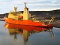
Im Jahr 2019 untersuchte eine Expedition von Victor Vescovo, die mit dem Tauchboot Limiting Factor die tiefsten Punkte aller Ozeane erreichen wollte, das Gebiet mit einem Lander und einem Fächerecholot. Bei der Kartierung wurde eine maximale Tiefe der Diamantina Fracture Zone von 7019 m ± 17 m im Dordrechttief festgestellt (33° 38′ S, 101° 21′ O). Auf Basis des GEBCO_2014 global bathymetry dataset und der Global Multi-Resolution Topography Synthesis berechneten Stewart und Jamieson die Tiefe des Dordrechttiefs auf 7090 bis 7100 m, der Ort musste gegenüber der Berechnung von 2018 jedoch korrigiert werden, im Vergleich zur Lotung 2019 lag er in einem zweiten, nördlich gelegenen Teil des Dordrechttiefs (33° 25′ S, 101° 29′ O).[1] An der im Jahr 1960 identifizierten Stelle des Diamantinatiefs beträgt die Wassertiefe nur 5300 m. Seitdem gilt das Dordrechttief als tiefste Stelle der Diamantina Fracture Zone, und der Javagraben mit 7290 m als tiefste Stelle des Indischen Ozeans.[1][20][21]

RV Vema
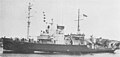
RV Argo

HMAS Diamantina
Forschungsschiff Nathaniel B. Palmer

Pressure Drop mit Tauchboot Limiting Factor
Weblinks
- computeranimierte Darstellung eines "Fluges" über die Diamantina Fracture Zone, basierend auf den topographischen Daten die im Rahmen der Five Deeps Expedition 2019 mit einem Fächerecholot gewonnen wurdenː Fly Through: Diamantina Fracture Zone auf YouTube (englisch)
Einzelnachweise
- ↑ a b c d e f g Heather A. Stewart, Alan J. Jamieson: The five deeps: The location and depth of the deepest place in each of the world's oceans. In: Earth-Science Reviews 197, Oktober 2019, 102896, doi:10.1016/j.earscirev.2019.102896.
- ↑ Marc Munschy, Jerome Dyment, Marie Odile Boulanger, Daniel Boulanger, Jean Daniel Tissot, Roland Schlich, Yair Rotstein, Millard F. Coffin: Breakup and Seafloor Spreading between the Kerguelen Plateau–Labuan Basin and the Broken Ridge–Diamantina Zone. In: S. W. Wise, Jr., R. Schlich et al. (Hrsg.): 1992 Proceedings of the Ocean Drilling Program, Scientific Results, Vol. 12051.
- ↑ a b c d Undersea Feature Names Gazetteer, General Bathymetric Chart of the Oceans. Suchbegriff „Diamantina“; Diamantina Fracture Zone, Diamantina Escarpment und Diamantina (East) Zone, Marine Gazetteer Placedetails, www.marineregions.org. Abgerufen am 12. Mai 2020.
- ↑ a b c Kim Picard, Brendan P. Brooke, Peter T. Harris, Paulus J. W. Siwabessy, Millard F. Coffin, Maggie Tran, Michele Spinoccia, Jonathan Weales, Miles Macmillan-Lawler, Jonah Sullivan: Malaysia Airlines flight MH370 search data reveal geomorphology and seafloor processes in the remote southeast Indian Ocean. In: Marine Geology 395, Januar 2018, S. 301–319, doi:10.1016/j.margeo.2017.10.014.
- ↑ South-west Corner Marine Park, parksaustralia.gov.au, abgerufen am 13. Mai 2020.
- ↑ a b c Dennis E. Hayes, John R. Conolly: Morphology of the Southeast Indian Coast. In: Dennis E. Hayes (Hrsg.): Antarctica Oceanology II: The Australian–New Zealand Sector, Volume 19, 1978, doi:10.1029/AR019p0125.
- ↑ a b Douglas F. Williams, Bruce H. Corliss: The South Australian Continental Margin and the Australian-Antarctic Sector of the Southern Ocean In: A. E. M. Nairn: The Ocean Basins and Margins: The Indian Ocean. Springer 2013, S. 566, ISBN 978-1-4615-8038-6.
- ↑ a b A. A. Bulychev, D. A. Gilod, E. P. Dubinin: Structure of the lithosphere of the northeastern part of the Indian Ocean according to results of two-dimensional structural-density modeling. In: Geotectonics 50, 2016, S. 257–275, doi:10.1134/S0016852116030043.
- ↑ Joanne M. Whittaker, Simon E. Williams, R. Dietmar Müller: Revised tectonic evolution of the Eastern Indian Ocean. In: Geochemistry, Geophysics, Geosystems, Band 14, Nr. 6, Juni 2013, S. 1891–1909, doi:10.1002/ggge.20120.
- ↑ a b J.-Y. Royer, D. T. Sandwell: Evolution of the eastern Indian Ocean since the Late Cretaceous: Constraints from Geosat altimetry. In: Journal of Geophysical Research: Solid Earth 94(B10), 1989, S. 13755–13782, doi:10.1029/jb094ib10p13755.
- ↑ a b c Heather A. Stewart, Alan J. Jamieson: Habitat heterogeneity of hadal trenches: considerations and implications for future studies. In: Progress in Oceanography 161, 2018, S. 47–65, doi:10.1016/j.pocean.2018.01.007.
- ↑ Samurdhika Rathnayake, Robert Tenzer, Mehdi Eshagh, Martin Pitoňák: Gravity Maps of the Lithospheric Structure Beneath the Indian Ocean. In: Surveys in Geophysics 40, 2019, S. 1055–1093, doi:10.1007/s10712-019-09564-6.
- ↑ Fabienne Chatin, Ursula Robert, Raymond Montigny, Hubert Whitechurch: La zone Diamantine (océan Indien oriental), témoin de la séparation entre l’Australie et l’Antarctique: arguments pétrologiques et géochimiques. In: Comptes rendus de l’Académie des sciences - Series IIA - Earth and Planetary Science, 326(12), 1998, S. 839–845, doi:10.1016/s1251-8050(98)80022-0.
- ↑ John C. Mutter, Steven C. Cande: The early opening between Broken Ridge and Kerguelen Plateau. In: Earth and Planetary Science Letters 65, 1983, S. 369–376, doi:10.1016/0012-821X(83)90174-7.
- ↑ John C. Mutter, Kerry A. Hegany, Steven C. Cande, Jeffrey K. Weissel: Breakup between Australia and Antarctica, a brief review in the light of new data. In: Tectonophysics 114, 1985, S. 255–279, doi:10.1016/0040-1951(85)90016-2.
- ↑ B. C. Heezen, Marie Tharp: Tectonic Fabric of the Atlantic and Indian Oceans and Continental Drift. In: Philosophical Transactions of the Royal Society, Series A, Mathematicaland Physical Sciences, Band 258, Nr. 1088, 28. Oktober 1965, S. 90–106, JSTOR 73335.
- ↑ Peter Nunan: HMAS Diamantina. 2. Ausgabe, Boolarong Press, Salisbury 2017. Zitiert nach Rezension von Alan Powell in: The Great Circle, Band 40, Nr. 1, 2018, S. 136–138, herausgegeben von der Australian Association for Maritime History, JSTOR 26783793.
- ↑ Peter Kenshole: ‘A Country Girt by Sea’: An Overview of Australian Maritime Exploration and Policy Drivers. In: Stuart Pearson, Jane L. Holloway, Richard Thackway (Hrsg.): Australian Contributions to Strategic and Military Geography. Springer, 2018, ISBN 978-3-319-73407-1, S. 39, doi:10.1007/978-3-319-73408-8_3.
- ↑ Vittorio Barale: The Asian Marginal and Enclosed Seas: An Overview. In: V. Barale, M. Gade (Hrsg.): Remote Sensing of the Asian Seas. Springer, Cham 2018, S. 3–38, doi:10.1007/978-3-319-94067-0_1.
- ↑ Heather Stewart, Alan Jamieson, Cassie Bongiovanni: Exploring the Deepest Points on Planet Earth: Report on The Five Deeps Expedition. www.hydro-international.com, 18. Juni 2019.
- ↑ Ben Taub, Paolo Pellegrin: Thirty-six Thousand Feet Under the Sea: The explorers who set one of the last meaningful records on earth. In: The New Yorker, 10. Mai 2020.
Auf dieser Seite verwendete Medien

R/V Argo underway, date and place unknown. US Navy photo from DANFS.

Autor/Urheber: Eli Duke, Lizenz: CC BY-SA 2.0
Antarctica Nathaniel B Palmer

Photograph of Australian frigate HMAS Diamantina.

Autor/Urheber: Richard Varcoe on behalf of Caladan Oceanic, Lizenz: CC BY-SA 4.0
Dieses Bild wurde im Rahmen der Tauchgänge im Atlantischen Ozean aufgenommen.
Autor/Urheber: Heather A. Stewart, Alan J. Jamieson, Lizenz: CC BY 4.0
Map of the deepest section of the Diamantina Fracture Zone with the locations of published ‘deeps’ (red circles) (Table 1). The 6000 m depth contour is shown in white. The deepest section of the feature is defined by the 7000 m contour (blue). All other contours at 200 m intervals (between 6000 and 7000 m water depth) (B) Inset map of Dordrecht Deep with the deepest point determined during this study (white star = between 7090 and 7100 m water depth) which is within 4 km of the published GEBCO Gazetteer location for Dordrecht Deep. The outer rim of Dordrecht deep lies at 5300 m water depth (pink contour). The 7000 m contour is coloured blue. All other contours at 100 m intervals (between 5300 and 7000 m water depth). For location of inset map see the red box in Fig. 5A. Illumination from 45° at an altitude of 25°.


Autor/Urheber: Uwe Dedering, Lizenz: CC BY-SA 3.0
Relief location map of Indian Ocean.
- Projection: Lambert azimuthal equal-area projection.
- Area of interest:
- N: 30.0° N
- S: -70.0° N
- W: 30.0° E
- E: 150.0° E
- Projection center:
- NS: -20.0° N
- WE: 90.0° E
- GMT projection: -JA90.0/-20.0/180/19.998266666666666c
- GMT region: -R-12.856058461183775/-43.848273739920856/151.50519408595028/33.22162400070504r
- GMT region for grdcut: -R-13.0/-78.0/193.0/34.0r
- Relief: SRTM30plus.
- Made with Natural Earth. Free vector and raster map data @ naturalearthdata.com.
Autor/Urheber: Pimvantend, Lizenz: CC BY-SA 3.0
Bathymetry of the wider Diamantina Zone. GMT, UTM49S.
Autor/Urheber: Pimvantend, Lizenz: CC BY-SA 3.0
Diamantina Fracture Zone (Diamantina Escarpment) marked in red. Land: dark green contours. Spreading ridges: heavy black lines. Fracture zones: black dashes. GMT, UTM zone 48 south.