Deuel County (Nebraska)
![Das Deuel County Courthouse, gelistet im NRHP Nr. 89002239[1]](http://upload.wikimedia.org/wikipedia/commons/thumb/5/53/Deuel_County%2C_Nebraska_courthouse_from_SE_1.JPG/298px-Deuel_County%2C_Nebraska_courthouse_from_SE_1.JPG) Das Deuel County Courthouse, gelistet im NRHP Nr. 89002239[1] | |
| Verwaltung | |
|---|---|
| US-Bundesstaat: | Nebraska |
| Verwaltungssitz: | Chappell |
| Adresse des Verwaltungssitzes: | County Courthouse 718 3rd P.O. Box 327 Chappell, NE 69129-0327 |
| Gründung: | 1889 |
| Gebildet aus: | Cheyenne County |
| Vorwahl: | 001 308 |
| Demographie | |
| Einwohner: | 1.838 (Stand: 2020) |
| Bevölkerungsdichte: | 1,61 Einwohner/km2 |
| Geographie | |
| Fläche gesamt: | 1142 km² |
| Wasserfläche: | 2 km² |
| Karte | |
| Website: www.co.deuel.ne.us | |
Das Deuel County[2] ist ein County im US-Bundesstaat Nebraska. Der Verwaltungssitz (County Seat) ist Chappell[3], das nach John Chappell benannt wurde, dem Präsidenten einer Eisenbahngesellschaft.
Geographie
Das County liegt im Westen von Nebraska, grenzt im Süden an Colorado und hat eine Fläche von 1142 Quadratkilometern, wovon 2 Quadratkilometer Wasserfläche sind. Es grenzt an folgende Countys:
| Garden County | ||
| Cheyenne County |  | Keith County |
| Sedgwick County (Colorado) | Perkins County |
Geschichte
Das Deuel County wurde 1889 aus ehemaligen Teilen des Cheyenne County gebildet. Benannt wurde es nach Harry Porter Deuel (1836–1914), einem Eisenbahnmanager aus Omaha.
Fünf Bauwerke und Stätten des Countys sind im National Register of Historic Places eingetragen (Stand 10. Februar 2018).[4]
Demografische Daten
| Bevölkerungswachstum | |||
|---|---|---|---|
| Census | Einwohner | ± rel. | |
| 1890 | 2.893 | — | |
| 1900 | 2.630 | −9,1 % | |
| 1910 | 1.786 | −32,1 % | |
| 1920 | 3.282 | 83,8 % | |
| 1930 | 3.992 | 21,6 % | |
| 1940 | 3.580 | −10,3 % | |
| 1950 | 3.330 | −7 % | |
| 1960 | 3.125 | −6,2 % | |
| 1970 | 2.717 | −13,1 % | |
| 1980 | 2.462 | −9,4 % | |
| 1990 | 2.237 | −9,1 % | |
| 2000 | 2.098 | −6,2 % | |
| 2010 | 1.941 | −7,5 % | |
| 2020 | 1.838 | −5,3 % | |
| Vor 1900[5] 1900–1990[6] 2000 + 2010[7] | |||
Nach der Volkszählung im Jahr 2010 lebten im Deuel County 1941 Menschen in 925 Haushalten. Die Bevölkerungsdichte betrug 1,7 Einwohner pro Quadratkilometer. In den 925 Haushalten lebten statistisch je 2,14 Personen.
Ethnisch betrachtet setzte sich die Bevölkerung zusammen aus 97,0 Prozent Weißen, 0,1 Prozent Afroamerikanern, 0,5 Prozent amerikanischen Ureinwohnern, 0,3 Prozent Asiaten sowie aus anderen ethnischen Gruppen; 1,2 Prozent stammten von zwei oder mehr Ethnien ab. Unabhängig von der ethnischen Zugehörigkeit waren 3,9 Prozent der Bevölkerung spanischer oder lateinamerikanischer Abstammung.
21,0 Prozent der Bevölkerung waren unter 18 Jahre alt, 55,3 Prozent waren zwischen 18 und 64 und 23,7 Prozent waren 65 Jahre oder älter. 50,9 Prozent der Bevölkerung war weiblich.
Das jährliche Durchschnittseinkommen eines Haushalts lag bei 38.594 USD. Das Prokopfeinkommen betrug 22.191 USD. 12,5 Prozent der Einwohner lebten unterhalb der Armutsgrenze.[8]
Städte und Gemeinden
|
|
Einzelnachweise
- ↑ Auszug aus dem National Register of Historic Places. Abgerufen am 13. März 2011
- ↑ GNIS-ID: 835846. Abgerufen am 22. Februar 2011 (englisch).
- ↑ National Association of Counties Abgerufen am 21. Oktober 2011
- ↑ Suchmaske Datenbank im National Register Information System. National Park Service, abgerufen am 10. Februar 2018.
- ↑ U.S. Census Bureau _ Census of Population and Housing Abgerufen am 17. Februar 2011
- ↑ Auszug aus Census.gov. Abgerufen am 17. Februar 2011
- ↑ Auszug aus census.gov (2000+2010) (Seite nicht mehr abrufbar, festgestellt im Mai 2023. Suche in Webarchiven.) Archivierte Webseiten von WebCite sind nicht mehr abrufbar (siehe Disk) Abgerufen am 13. April 2012
- ↑ U.S. Census Buero, State & County QuickFacts - Deuel County (Seite nicht mehr abrufbar, festgestellt im Mai 2023. Suche in Webarchiven.) Archivierte Webseiten von WebCite sind nicht mehr abrufbar (siehe Disk) Abgerufen am 21. Oktober 2011
Weblinks
Koordinaten: 41° 7′ N, 102° 20′ W
Auf dieser Seite verwendete Medien
This is a locator map showing Deuel County in Nebraska. For more information, see Commons:United States county locator maps.
Autor/Urheber: Smallbones, Lizenz: CC0
Fred and Minnie Meyer Sudman House on the NRHP since December 6, 1990. At 490 Vincent Ave., Chappell, Deuel County, Nebraska
Autor/Urheber:
- real name: Artur Jan Fijałkowski
- pl.wiki: WarX
- commons: WarX
- mail: [1]
- jabber: WarX@jabber.org
- irc: [2]
- software: own perl scripts
Age pyramid for Deuel County, Nebraska, United States of America, based on census 2000 data
Deuel County Courthouse in Chappell, Nebraska; seen from the southeast. The Classical Revival building was constructed in 1915. It is listed in the National Register of Historic Places.
Autor/Urheber: Smallbones, Lizenz: CC0
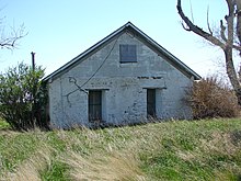
Wallace W. Waterman Sod House on rthe NRHP since February 17, 1995. On Day Rd., 9 miles north of Big Springs, Deuel County, Nebraska, roughly 10 miles west of the middle of nowhere. The house is not immediately identifiable as a sod house, since it is covered by stucco or cement. The thickness of the walls and a lack of definition in the corners, windows, etc. gives it away though. The stucco is cracked in a way that reveals blocks of something underneath. If this speculation is correct, then the sod blocks must have been at least 2 feet thick. Farm site is not lived in now, but across the street are modern storage facilities.
Autor/Urheber: Ammodramus, Lizenz: CC0
Menter farmstead, located on North Fork Road northwest of Big Springs, Nebraska. Barn and granary, seen from the northeast.


