Davlos/Kaplıca
| Davlos Δαυλός Kaplıca | ||
|---|---|---|
| ||
| Basisdaten | ||
| Staat: | ||
| Distrikt: | ||
| Geographische Koordinaten: | 35° 25′ N, 33° 54′ O | |
| Höhe ü. d. M.: | 126 m | |
| Einwohner: | 389 (2011) | |
Davlos (griechisch Δαυλός), türkisch Kaplıca, ist ein Ort auf der Karpas-Halbinsel im Nordosten der Mittelmeerinsel Zypern. 2011 zählte er 389 Einwohner.[1]

Davlos bedeutet „Feuerholz“. Der türkische Name Kaplıca bedeutet ‚warme Quelle‘ nach einer Mineralquelle in der Nähe des Dorfes.
Geschichte
Davlos entstand nahe der Nordküste, drei Kilometer von der Kantara-Burg entfernt. Bis 1974 war das Dorf ausschließlich von Zyperngriechen bewohnt.
Die erste osmanische Zählung von 1831 nennt 33 griechische Haushaltsvorstände. 1891, unter britischer Kolonialherrschaft, lag die Einwohnerzahl bei 396, wobei vier Türken im Dorf lebten. Diese vier zählte man auch 1911, und bis 1921 stieg ihre Zahl auf 14. Derweil wuchs die Zahl der Griechen von 474 (1901) über 558 (1911) auf 661 bzw. 662 in den Zählungen der Jahre 1921 und 1931. In dieser Zeit verließen die wenigen Türken das Dorf. Die Einwohnerzahl sank auf 599 im Jahr 1946 und fiel auf 462 im Jahr 1960, um 1973 mit nur mehr 342 Einwohnern einen Tiefpunkt zu erreichen.

Die 1974 verbliebenen etwa 270 Bewohner blieben im Dorf, doch wurden auch sie im Sommer 1975 aus Rache wegen der Übergriffe griechischer Nationalisten vertrieben. Insgesamt dürfte sich die Zahl der Geflohenen aus Davlos auf etwa 350 belaufen.
1976 und 1977 kamen türkische Neusiedler aus Uzuntarla (Alithinos) im Distrikt Çaykara vom Schwarzen Meer. 2006 zählte Kaplıca 408 Einwohner, 2011 nur noch 389.
Weblinks
Anmerkungen
- ↑ KKTC 2011 Nüfus ve Konut Sayımı. (PDF) (Nicht mehr online verfügbar.) TRNC, 6. August 2013, archiviert vom am 24. Dezember 2018; abgerufen am 25. April 2016.
Auf dieser Seite verwendete Medien
A blue dot only / Nur ein blauer Punkt
Autor/Urheber: Julian Nyča, Lizenz: CC BY-SA 3.0
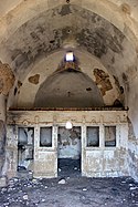
Entweihte Kapelle, nach der Kameraposition bei Çiftlikdüzü (de:Akanthou/Tatlısu) auf der Karpas-Halbinsel, Zypern.
(c) Karte: NordNordWest, Lizenz: Creative Commons by-sa-3.0 de
Positionskarte von Zypern
Autor/Urheber:
| Kameraposition | | Dieses und weitere Bilder auf OpenStreetMap |
|---|
Davlos and Kantara
Davlos is a purely Greek community of the occupied part of the District of Ammochostos.
Geographical Location: It lies 34 klm North of the town of Ammochostos, on the Northern slopes of the Pentadaktylos mountain range, one klm away from the coast at a height of 70m.
Population: The population of these communities in 1960 numbered 462 all Greek.
Schools: The greek Primary School that operated here before the Turkish Invasion of 1974 had during the 1973-74 school year 30 students.
Effects of Turkish Invasion: During the Turkish Invasion of 1974 the communities were taken over by the Turkish army and as a result the whole of their Greek population was displaced. Since then, the Turkish occupation forces and the illegal occupation authority prohibit their return.
From:http://kypros.org/Occupied_Villages/amm1-gee.html


