Dallas-Fort-Worth-Metroplex
| Dieser Artikel wurde aufgrund von inhaltlichen Mängeln auf der Qualitätssicherungsseite des Projektes USA eingetragen. Hilf mit, die Qualität dieses Artikels auf ein akzeptables Niveau zu bringen, und beteilige dich an der Diskussion! Folgende Mängel sollten behoben werden, bevor diese Markierung entfernt werden kann: Ausbau samt Quellen --Crazy1880 20:40, 23. Jul. 2012 (CEST) |  |


Der Dallas-Fort-Worth-Metroplex ist eine Metropolregion in den Vereinigten Staaten um die Städte Dallas, Arlington (Texas) und Fort Worth. Er zählt als 61.-größter Verdichtungsraum weltweit und viertgrößter der USA; größter Verdichtungsraum von Texas und derzeit (2020) gemäß US Census die Metropolregion mit der höchsten Bevölkerungswachstums-Quote der USA.[1]
Die Metropolregion wird vom Office of Management and Budget zu statistischen Zwecken als Dallas–Fort Worth–Arlington, TX Metropolitan Statistical Area geführt.[2] Zum Zeitpunkt der Volkszählung von 2020 hatte das Gebiet 7.637.387 Einwohner.[3]
Die Region lässt sich unterteilen in Dallas–Plano–Irving und Fort Worth–Arlington.[4]
Countys

Über die Stadträume der Millionenstädte hinaus erstreckt sich der Metroplex über 12 Countys, wobei auch noch die Städte Carrollton, Denton, McKinney und Richardson dazugezählt werden.
- Collin County
- Dallas County
- Delta County
- Denton County
- Ellis County
- Hood County
- Hunt County
- Johnson County
- Kaufman County
- Parker County
- Rockwall County
- Somervell County
- Tarrant County
- Wise County
Siehe auch
Einzelnachweise
- ↑ US Census Bureau: Metropolitan and Micropolitan Statistical Areas Totals: 2010-2019. In: census.gov. Abgerufen am 23. März 2024.
- ↑ OMB BULLETIN NO. 20-01. Abgerufen am 25. April 2022.
- ↑ 2020 Population and Housing State Data. Abgerufen am 26. April 2022.
- ↑ US Census Bureau: Metropolitan and Micropolitan Statistical Areas Totals: 2010-2019. In: census.gov. Abgerufen am 23. März 2024.
Auf dieser Seite verwendete Medien
Created by troy34 on 4/1/07
Most metropolitan areas of the western United States are spread over large areas with regular street grid patterns that are highly recognizable from space (particularly at night). The northern Dallas metro area in Texas exhibits this pattern in this astronaut photograph from the International Space Station.
The north-south and east-west grid of major streets is highlighted by orange lighting, which lends a fishnet-like appearance to the urban area. Smaller residential and commercial buildings give green-gray stipple patterns to some blocks. The airplane terminals of Dallas-Fort Worth International Airport are lit with golden-yellow lights and surrounded by relatively dark runways and fields. Likewise, the runways of Dallas Love Field are recognizable by their darkness.
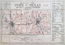
Other dark areas within the metro region are open space, parks, and water bodies. Larger commercial areas, as well as public and industrial facilities, appear as brilliantly lit regions and points.This map details paved roads, partially improved roads, railroads and electric interurban lines in Dallas and Tarrant Counties as of 1915. The map's compiler was consulting and construction engineer Fred A. Jones (1875-1928). He and his company were among the leading contractors in the Southwestern U.S. between 1906 and 1930. He played a major role in the development of the interurban railroad and water systems of North Texas, and he supervised the construction of such buildings as the original Dallas Country Club, Dallas Hall at SMU, the Dallas Municipal Building, the Southland Building, White Rock Lake and Wastewater Purification Plant, and the Texas Farm and Ranch Building. Bert Firmin was a draftsman who worked for Jones and for the Missouri, Kansas and Texas (Katy) Railroad.


