Corydon (Indiana)
| Corydon | |
|---|---|
 | |
| Lage in Indiana | |
| Basisdaten | |
| Gründung: | 1808 |
| Staat: | Vereinigte Staaten |
| Bundesstaat: | Indiana |
| County: | Harrison County |
| Koordinaten: | 38° 13′ N, 86° 8′ W |
| Zeitzone: | Eastern (UTC−5/−4) |
| Einwohner: | 3.153 (Stand: 2020) |
| Haushalte: | 1.365 (Stand: 2020) |
| Fläche: | 4,24 km2 (ca. 2 mi²) |
| Bevölkerungsdichte: | 744 Einwohner je km2 |
| Postleitzahl: | 47112 |
| Vorwahl: | +1 812 |
| FIPS: | 18-15256 |
| GNIS-ID: | 0433003 |
| Website: | townofcorydon.com |
Corydon ist eine Town im Harrison Township in Indiana. Sie liegt nördlich des Ohio River im äußersten Süden des US-Bundesstaates Indiana und ist Regierungssitz des Harrison County.
Geschichte
Corydon wurde 1808 gegründet. Von 1813 bis 1816 war Corydon die Hauptstadt des Indiana-Territoriums und war auch die erste Hauptstadt des neu gegründeten Staates Indiana.[1] Allerdings wurde 1821 Indianapolis auf Initiative des Staates Indiana gegründet und wurde 1825 dessen neue Hauptstadt. Während des Sezessionskriegs fand am 9. Juli 1863 die Schlacht von Corydon statt.[2]
Sehenswürdigkeiten
- Old State Capitol
- Governor Hendricks' Headquarters
- Constitution Elm Memorial
- Old Treasury Building
- Battle of Corydon Memorial Park
Weblinks
Einzelnachweise
- ↑ Bennett, Pamela J., ed.: Indiana Statehood. In: The Indiana Historian. Indiana Historical Bureau, Oktober 1999.
- ↑ Battle of Corydon July 9, 1863. Indiana Historical Bureau, abgerufen am 11. August 2016.
Auf dieser Seite verwendete Medien
(c) DemocraticLuntz in der Wikipedia auf Englisch, CC BY-SA 4.0
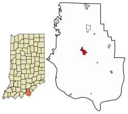
Location of Corydon in Harrison County, Indiana.
FIPS code: 18-15256
Own work, based on concept by Arkyan, using Census Bureau Tiger GIS data and a custom fork of Kartography adapted for this purpose, available atThis is a locator map showing Harrison County in Indiana. For more information, see Commons:United States county locator maps.
An image of downtown Corydon, Indiana, viewed from the Pilot Knob in the Hayswood Nature Reserve on the west side of the town.
(c) I, W.marsh, CC BY-SA 3.0
Harrison County, Indiana Courthouse


