Convoy (County Donegal)
| Convoy Conmhaigh Convoy | |||
|---|---|---|---|
| |||
| Koordinaten | 54° 51′ 35″ N, 7° 40′ 1″ W | ||
| Basisdaten | |||
| Staat | Irland | ||
| Provinz | Ulster | ||
| Grafschaft | Donegal | ||
| ISO 3166-2 | IE-DL | ||
| Höhe | 40 m | ||
| Fläche | 1,7 km² | ||
| Einwohner | 1702 (2022[1]) | ||
| Dichte | 977,6 Ew./km² | ||
| Telefonvorwahl | +353 (0)74 | ||
 Main Street in Convoy | |||
Convoy (irisch Conmhaigh, deutsch: „Ebene der Hunde“) ist eine Kleinstadt (Town) im County Donegal im Nordwesten der Republik Irland. Die Einwohnerzahl von Convoy wurde bei der Volkszählung 2022 mit 1702 Personen ermittelt.[1]
Geografie
Convoy liegt etwa 15 Kilometer südsüdöstlich von Letterkenny am Burn Dale im Osten der Grafschaft Donegal, etwa zehn Kilometer von der Grenze zu Nordirland. Durch die Gemeinde führt die R236 aus Richtung Ballybofey−Stranorlar weiter über Raphoe Richtung Saint Johnstown.
Sehenswürdigkeiten
- anglikanische St. Ninian’s Church
- katholische Marienkirche
- presbyterianische Kirche
- alte Wollmühle
 (c) Kenneth Allen, CC BY-SA 2.0St. Ninian’s Church
 (c) Kenneth Allen, CC BY-SA 2.0Marienkirche
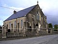 (c) Kenneth Allen, CC BY-SA 2.0Presbyterianische Kirche
 (c) Kenneth Allen, CC BY-SA 2.0Wollmühle
Weblinks
Commons: Convoy – Sammlung von Bildern, Videos und Audiodateien
Einzelnachweise
- ↑ a b Convoy (Agglomeration) auf citypopulation.de, abgerufen am 15. September 2024
Auf dieser Seite verwendete Medien

St Ninian's Church of Ireland, Convoy - geograph.org.uk - 993056.jpg
(c) Kenneth Allen, CC BY-SA 2.0
St Ninian's Church of Ireland, Convoy It is located off the main road,; it is in the Diocese of Derry and Raphoe
(c) Kenneth Allen, CC BY-SA 2.0
St Ninian's Church of Ireland, Convoy It is located off the main road,; it is in the Diocese of Derry and Raphoe

Convoy RC Church - geograph.org.uk - 993065.jpg
(c) Kenneth Allen, CC BY-SA 2.0
Convoy RC Church Built in a modern style, it is located to the east of the town
(c) Kenneth Allen, CC BY-SA 2.0
Convoy RC Church Built in a modern style, it is located to the east of the town

Mill, Convoy - geograph.org.uk - 993068.jpg
(c) Kenneth Allen, CC BY-SA 2.0
Mill, Convoy Looking east at Riverview Terrace
(c) Kenneth Allen, CC BY-SA 2.0
Mill, Convoy Looking east at Riverview Terrace

Ireland adm location map.svg
(c) Karte: NordNordWest, Lizenz: Creative Commons by-sa-3.0 de
Positionskarte von Irland
(c) Karte: NordNordWest, Lizenz: Creative Commons by-sa-3.0 de
Positionskarte von Irland

Convoy Presbyterian Church - geograph.org.uk - 993060.jpg
(c) Kenneth Allen, CC BY-SA 2.0
Convoy Presbyterian Church It is located off the main street
(c) Kenneth Allen, CC BY-SA 2.0
Convoy Presbyterian Church It is located off the main street