Colombières
| Colombières | ||
|---|---|---|
| ||
| Staat | Frankreich | |
| Region | Normandie | |
| Département (Nr.) | Calvados (14) | |
| Arrondissement | Bayeux | |
| Kanton | Trévières | |
| Gemeindeverband | Isigny-Omaha Intercom | |
| Koordinaten | 49° 18′ N, 0° 59′ W | |
| Höhe | 0–33 m | |
| Fläche | 11,04 km² | |
| Einwohner | 208 (1. Januar 2018) | |
| Bevölkerungsdichte | 19 Einw./km² | |
| Postleitzahl | 14710 | |
| INSEE-Code | 14168 | |
Colombières ist eine französische Gemeinde im Département Calvados in der Region Normandie mit 208 Einwohnern (Stand: 1. Januar 2018). Colombières gehört zum Arrondissement Bayeux und zum Kanton Trévières.
Geografie
Colombières liegt etwa 29 Kilometer westnordwestlich von Bayeux. Umgeben wird Colombières von den Nachbargemeinden Canchy und Longueville im Norden, Écrammeville im Nordosten, Bricqueville im Osten und Südosten, Isigny-sur-Mer im Süden und Westen, Monfréville im Westen und Nordwesten sowie La Cambe im Nordwesten.
Bevölkerungsentwicklung
| 1962 | 1968 | 1975 | 1982 | 1990 | 1999 | 2006 | 2013 |
|---|---|---|---|---|---|---|---|
| 362 | 306 | 231 | 247 | 218 | 225 | 196 | 207 |
| Quelle: Cassini und INSEE | |||||||
Sehenswürdigkeiten
- Kirche
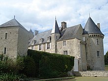
- Schloss Colombières aus dem 14. Jahrhundert, Monument historique
Weblinks
Auf dieser Seite verwendete Medien
(c) Karte: NordNordWest, Lizenz: Creative Commons by-sa-3.0 de
Positionskarte von Frankreich mit Regionen und Départements
Vue du Château de Colombières


