Champ-Insel
| Champ-Insel | ||
|---|---|---|
 | ||
| Gewässer | Arktischer Ozean | |
| Inselgruppe | Franz-Josef-Land | |
| Geographische Lage | 80° 41′ N, 56° 21′ O | |
| Länge | 27 km | |
| Breite | 18 km | |
| Fläche | 374,3 km² | |
| Höchste Erhebung | 507 m | |
| Einwohner | unbewohnt | |
 | ||
Die Champ-Insel (russisch Чамп, Tschamp) ist eine unbewohnte Insel des zu Russland gehörenden arktischen Franz-Josef-Lands.
Geographie
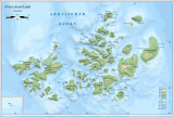
Die 374 km² große Champ-Insel liegt zentral im Archipel Franz-Josef-Land. Sie ist die südlichste einer Gruppe von Inseln, die nur durch schmale, fast ganzjährig vereiste Meerengen voneinander getrennt sind und zunächst als eine zusammenhängende Landmasse, Zichy-Land, angesehen wurden. Von der nördlich gelegenen Salisbury-Insel ist die Champ-Insel lediglich durch die nur wenige hundert Meter breite Pondorff-Enge getrennt, von der Luigi-Insel im Nordwesten durch die Cook-Straße. Die Champ-Insel ist stark vergletschert. Ihre Küstenlinie besteht zu mehr als 50 % aus Gletscherabbruchkanten.
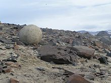
Eine geologische Besonderheit sind die zahlreichen Konkretionen – Steine, die sich jeweils um ein zentrales Fossil gebildet haben. Man findet sie besonders an den Kaps der Südküste, Kap Fiume und Kap Triest. Sie stammen aus dem Obertrias und sind oft von perfekter Kugelgestalt mit bis zu drei Metern Durchmesser.[1]
An der südlichen und westlichen Küste gibt es einige Kolonien von Seevögeln. Am häufigsten brüten hier Dreizehenmöwen und Krabbentaucher.[2]
Geschichte
Die Südostküste der Insel zwischen Kap Fiume und Kap Triest wurde 1874 von der Österreich-Ungarischen Nordpolarexpedition (1872–1874) als Teil von Zichy-Land kartiert, das nach Graf Ödön Zichy (1811–1894), einem der Hauptsponsoren der Expedition, benannt war. Erst die Fiala-Ziegler-Expedition (1903–1905) stellte den eigenständigen Charakter der Insel fest. Anthony Fiala benannte sie nach William S. Champ, der die in Not geratenen Männer 1905 gerettet hatte.[3]
Einzelnachweise
- ↑ Friedhelm Thiedig: Fahrt zum Geografischen Nordpol und zum Franz Josef Land (2005) – mit Beschreibung der Klagenfurt Inseln und der auffällig großen Steinkugeln östlich Kap Fiume auf Champ Island (FJL). In: Carinthia II. 196./116. Jahrgang, Klagenfurt 2006, S. 9–32 (zobodat.at [PDF; 11,2 MB]).
- ↑ Meredith Williams, Julian A. Dowdeswell: Mapping seabird nesting habitats in Franz Josef Land, Russian High Arctic, using digital Landsat Thematic Mapper imagery. In: Polar Research. Band 17, 1998, S. 15–30 (englisch). doi:10.3402/polar.v17i1.6604.
- ↑ Anthony Fiala: Fighting the Polar Ice. Doubleday, Page & Co., New York 1907, S. 193.
Weblinks
- Andreas Umbreit: Champ Insel, Steinkugeln (Geoden) – Franz-Joseph-Land (Memento vom 28. Januar 2021 im Internet Archive)
Auf dieser Seite verwendete Medien
(c) Polarstar, CC BY-SA 3.0
Geode auf der Champ-Insel, Franz-Josef-Land, Russland
Autor/Urheber: User:Mysid, Lizenz: CC BY-SA 3.0
Map of central Franz Josef Land
Autor/Urheber: Nzeemin, Lizenz: CC BY-SA 3.0
Физическая карта -- Земля Франца-Иосифа, Россия.
- Проекция: Lambert Azimuthal Equal-Area
- Longitude and latitude of the projection center: 55 / 80.8
- Инструменты: GMT
Autor/Urheber: Oona Räisänen (übersetzt durch Thariama), Lizenz: CC BY 3.0
Karte des russischen Franz-Josef-Land.
Autor/Urheber: NASA's Earth Observatory, Lizenz: CC BY 2.0
To download the full resolution and other files go to: earthobservatory.nasa.gov/IOTD/view.php?id=76883&src=...
Located just 600 miles (970 kilometers) from the North Pole, Franz Josef Land is perpetually coated with ice. Glaciers cover roughly 85 percent of the archipelago’s land masses, and sea ice floats in the channels between islands even in the summertime.
The Advanced Spaceborne Thermal Emission and Reflection Radiometer (ASTER) on NASA’s Terra satellite observed the islands of central Franz Josef Land on August 16 and 19, 2011. (Another sensor on Terra captured a wider view on August 17, 2011.)
The image above was made from a combination of visible and near-infrared wavelengths, and ice appears in shades of white and pale blue. The amount of sea ice filling the channels between the islands of Franz Josef Land varies from summer to summer. Captured toward the end of the Northern Hemisphere melt season, this shot shows a modest amount of sea ice on the ocean surface. Some of the ice has accumulated in bays like the one near northeastern Zieger Island.
Most of the ice in this scene is anchored to land, as large glaciers blanket the islands. Yet today’s glaciers are tiny compared to the ice sheet that dominated the region about 20,000 years ago. Studies of Franz Josef Land have actually contributed to a larger understanding of when that massive ice sheet began its slow retreat. Raised beaches, which preserve evidence of land rising as the crushing weight of overlying glaciers eases (known as isostatic rebound), were first recognized on the islands in the late nineteenth century. Researchers estimate that the giant ice sheet had retreated by about 10,000 years ago.
NASA image created by Jesse Allen, using data provided courtesy of NASA/GSFC/METI/ERSDAC/JAROS, and U.S./Japan ASTER Science Team. Caption by Michon Scott with information from Walt Meier and Ted Scambos, National Snow and Ice Data Center.
The Earth Observatory's mission is to share with the public the images, stories, and discoveries about climate and the environment that emerge from NASA research, including its satellite missions, in-the-field research, and climate models.
Like us on Facebook
Follow us on Twitter
Add us to your circles on Google+


