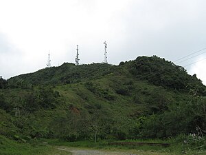
Cerro de Punta
| Cerro La Punta | ||
|---|---|---|
 | ||
| Höhe | 1338 m | |
| Lage | Puerto Rico, Vereinigte Staaten | |
| Gebirge | Cordillera Central | |
| Koordinaten | 18° 10′ 22″ N, 66° 35′ 24″ W | |
Der Cerro de Punta ist mit 1338 m der höchste Berg im US-amerikanischen Außengebiet Puerto Rico. Er ist Teil der Gebirgskette Cordillera Central. Der Berg liegt auf dem Gebiet der Gemeinde Ponce.[1]
Einzelnachweise
- ↑ Cerro La Punta, The High Point of Puerto Rico. (Nicht mehr online verfügbar.) Archiviert vom am 11. März 2013; abgerufen am 7. Februar 2013 (englisch).
Auf dieser Seite verwendete Medien
"Mount Rainier towers over all surrounding mountains, lit by the sunset and wreathed in clouds."
Autor/Urheber: Ratzer1, Lizenz: CC BY-SA 3.0
Cerro Punta, highest peak of Puerto Rico, from Scenic Route
Autor/Urheber: GrandEscogriffe, Lizenz: CC BY-SA 4.0
Topographic location map of Puerto Rico, USA
Equirectangular projection, N/S stretching 105 %. Geographic limits of the map:
- N: 19.0° N
- S: 17.5° N
- W: 68.0° W
- E: 65.2° W


