Centreville (Virginia)
| Centreville | |
|---|---|
Lage von Centreville im Fairfax County | |
| Basisdaten | |
| Staat: | Vereinigte Staaten |
| Bundesstaat: | Virginia |
| County: | Fairfax County |
| Koordinaten: | 38° 51′ N, 77° 27′ W |
| Zeitzone: | Eastern (UTC−5/−4) |
| Einwohner: | 73.518 (Stand: 2020) |
| Haushalte: | 23.830 (Stand: 2020) |
| Fläche: | 31,2 km² (ca. 12 mi²) davon 30,9 km² (ca. 12 mi²) Land |
| Bevölkerungsdichte: | 2.379 Einwohner je km² |
| Höhe: | 117 m |
| Postleitzahlen: | 20120 – 20122 |
| FIPS: | 51-14440 |
| GNIS-ID: | 1491083 |
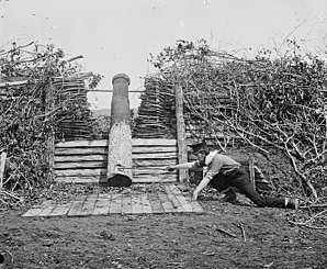
 Quaker Gun bei Centreville im März 1862 | |
Centreville ist ein Ort (CDP) im Fairfax County an der Abzweigung der Interstate 66 vom U.S. Highway 50 nahe Washington, D.C. im US-Bundesstaat Virginia.
Im Winter 1861/1862 des Sezessionskrieges lag die konföderierte Armee hier in Stellung und erhielt die Erstausstattung mit der Flagge der Konföderierten Staaten von Amerika; zudem befindet sich am Westrand der Gemeinde der Bull Run, Schauplatz und Namensgeber zweier Schlachten.
Der örtliche Baseballclub SYA East LL hat Virginia zweimal bei regionalen Jugendwettkämpfen vertreten.
Persönlichkeiten
- Caron Butler (* 1980), Basketballspieler
- Ormond Stone (1847–1933), Mathematiker
Weblinks
Auf dieser Seite verwendete Medien
This map shows the incorporated areas and unincorporated areas in Fairfax County, Virginia. Centreville is highlighted in red. Other incorporated cities are shown in gray and CDPs in white. Map data is based on the following files as noted:
- Fairfax County Virginia US Census Tracts & Block Groups (.pdf)
- Index of US Census Bureau maps of the Washington D.C. metro area (individual map files are .pdf files.)
- Map of Virginia highlighting Fairfax County.svg
Centreville, Virginia. Quaker gun


