Castropodame
| Gemeinde Castropodame | ||
|---|---|---|
 Castropodame | ||
| Wappen | Karte von Spanien | |
 | ||
| Basisdaten | ||
| Land: | ||
| Autonome Gemeinschaft: | ||
| Provinz: | León | |
| Comarca: | El Bierzo | |
| Gerichtsbezirk: | Ponferrada | |
| Koordinaten | 42° 35′ N, 6° 28′ W | |
| Höhe: | 747 msnm | |
| Fläche: | 59,60 km² | |
| Einwohner: | 1.577 (1. Jan. 2022)[1] | |
| Bevölkerungsdichte: | 26 Einw./km² | |
| Postleitzahl(en): | 24314 | |
| Gemeindenummer (INE): | 24049 | |
| Verwaltung | ||
| Bürgermeisterin: | Josefa Álvarez Fernández (PSOE) | |
| Website: | Castropodame | |
| Lage des Ortes | ||
Castropodame ist eine Gemeinde mit 1577 Einwohnern (Stand: 1. Januar 2022) im nordwestlichen Zentral-Spanien in der Provinz León in der Autonomen Gemeinschaft Kastilien-León. Die Gemeinde besteht neben dem Hauptort Castropodame aus den Ortschaften Calamocos, Matachana, San Pedro Castañero, Turienzo Castañero, Viloria und Villaverde de los Cestos.
Geografie
Castropodame liegt etwa 100 Kilometer westlich von León in einer Höhe von ca. 745 m.
Bevölkerungsentwicklung
| Jahr | 1900 | 1950 | 1970 | 1981 | 1991 | 2001 | 2011 | 2021 |
|---|---|---|---|---|---|---|---|---|
| Einwohner | 2534 | 2714 | 2733 | 2207 | 1933 | 1841 | 1780 | 1605 |
| Quelle: INE[2] | ||||||||
Sehenswürdigkeiten
- Kolumbakirche in Castropodame
- Christuskapelle in Castropodame
- Christuskapelle in Las Maravillas-Matachana
- Petri-Ketten-Kirche in San Pedro Castañero
- Martinskirche in Villaverde de los Cestos
- Rathaus
Kolumbakirche
Christuskapelle in Castropodame
Petri-Ketten-Kirche
Rathaus
Weblinks
Einzelnachweise
- ↑ Cifras oficiales de población de los municipios españoles en aplicación de la Ley de Bases del Régimen Local (Art. 17). Instituto Nacional de Estadística (Bevölkerungsstatistiken des Instituto Nacional de Estadística, Stand 1. Januar 2022).
- ↑ Castropodame - Bevölkerungsentwicklung
Auf dieser Seite verwendete Medien
Autor/Urheber: NordNordWest, Lizenz: CC BY-SA 3.0
Positionskarte von Spanien
Quadratische Plattkarte, N-S-Streckung 130 %. Geographische Begrenzung der Karte:
- N: 44.4° N
- S: 34.7° N
- W: 9.9° W
- O: 4.8° O
All vehicles prohibited.
Bandera de Castilla y León
Autor/Urheber: SanchoPanzaXXI(Taller de Heráldica y Vexilología in the Spanish Wikipedia
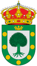
Escudo municipal de Castropodame (León): De plata, castaño arrancado de sinople. Bordura de sinople con siete roeles de oro y en su jefe, Corona Real abierta de oro. Al timbre Corona Real cerrada. B.O.C. y L. - N.º 46 Viernes, 7 de marzo 2003.
Autor/Urheber: Hovallef, Lizenz: CC BY-SA 4.0
Ayuntamiento de Castropodame vista frontal, provincia de León, El Bierzo.
Autor/Urheber: Hovallef, Lizenz: CC BY-SA 4.0
Ermita del Cristo en Castropodame, provincia de León, comarca de El Bierzo.
Autor/Urheber: Hovallef, Lizenz: CC BY-SA 4.0
San Pedro Castañero es una localidad que pertenece al municipio de Castropodame en la comarca de El Bierzo, provincia de León.
Autor/Urheber: Hovallef, Lizenz: CC BY-SA 4.0
Iglesia de Santa Colomba en Castropodame, provincia de León, comarca de El Bierzo.
Autor/Urheber: Gabriel Fdez., Lizenz: CC BY 2.0
Castropodame
Autor/Urheber: Tschubby, Lizenz: CC BY-SA 3.0
Gemeinde Castropodame


