Caraballo-Berge
| Caraballoberge | |
|---|---|
 Die Caraballoberge zwischen der Cordillera Central und der Sierra Madre | |
| Lage | Luzon, Philippinen |
| Koordinaten | 16° 11′ N, 121° 9′ O |
Die Caraballo-Berge (spanisch Monte Caraballo oder Sierra de Caraballo) sind ein Gebirge auf den Philippinen. Es befindet sich in der zentralen nördlichen Region der Insel Luzon und umfasst Gebiete der Provinzen Nueva Vizcaya und Quirino. Es bildet den zentralen Gebirgsknoten der Insel und erreicht eine Höhe von ca. 1680 Metern über dem Meeresspiegel.
Die Caraballoberge bilden die Wasserscheide zwischen dem Cagayan und dem Pampanga, deren Hauptquellgebiete in diesem Gebirgszug liegen. Im Süden des Gebirgszuges liegt einer der größten Stauseen der Philippinen, der Pantabangan-Stausee. Die Caraballoberge sind größtenteils bewaldet, sehr ursprünglich und nur gering besiedelt.
Die Marhalika Highway durchquert den Gebirgszug im Nordwesten, dennoch ist das Gebiet sehr abgelegen. Das bedeutende Pilgerzentrum Station of the Cross liegt im Bangan-Hill-Nationalpark, im Norden des Gebirges.
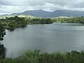
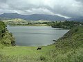
Der Pantabangan-Stausee
Die Caraballoberge
Der Dalton-Pass
Weblinks
Auf dieser Seite verwendete Medien

Autor/Urheber: Ramon FVelasquez, Lizenz: CC BY-SA 3.0
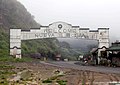
Canili and Diayo Dams and Reservoirs, Maria Aurora [1] (Manmade Structures Dams, Coordinates (WGS84) 15° 47.351N 121° 19.066E Elev: 309m)[2][3]. The four-decade old dam is a tributary of Pantabangan Dam that irrigates more than 100,000 hectares of farmlands in the provinces of Pampanga, Nueva Ecija, Tarlac and Bulacan in Central Luzon. Diayo dam, which was simultaneously built along with Pantabangan Dam in 1970s, was designed only for light vehicles. The dam has been transformed into a major part of BPR when Baler-Bongabon road, then a major road network linking Aurora to Nueva Ecija, was devastated by a series of typhoons in 2004. The Dams are situated in the deep canyons of the Canili and Diayo rivers in the Baler-Aurora basin. The confluence of the two rivers is about 800 meters downstream of the Canili damsite where it forms the Cabatangan River, which flows east to the town of Baler and empties into the Philippines Sea.[4]

Autor/Urheber: Ramon FVelasquez, Lizenz: CC BY-SA 3.0
Canili and Diayo Dams and Reservoirs, Maria Aurora [1] (Manmade Structures Dams, Coordinates (WGS84) 15° 47.351N 121° 19.066E Elev: 309m)[2][3]. The four-decade old dam is a tributary of Pantabangan Dam that irrigates more than 100,000 hectares of farmlands in the provinces of Pampanga, Nueva Ecija, Tarlac and Bulacan in Central Luzon. Diayo dam, which was simultaneously built along with Pantabangan Dam in 1970s, was designed only for light vehicles. The dam has been transformed into a major part of BPR when Baler-Bongabon road, then a major road network linking Aurora to Nueva Ecija, was devastated by a series of typhoons in 2004. The Dams are situated in the deep canyons of the Canili and Diayo rivers in the Baler-Aurora basin. The confluence of the two rivers is about 800 meters downstream of the Canili damsite where it forms the Cabatangan River, which flows east to the town of Baler and empties into the Philippines Sea.[4]
Autor/Urheber: Alexander Altenhof (KaterBegemot), Lizenz: CC BY 3.0
Topografische Karte des Nordteils der Philippinen-Insel Luzon mit der Babuyan-Inselgruppe. Verwendete Daten: NASA Shuttle Radar Topography Mission digital topographic data (SRTM3 2.1) (Public Domain) und Philippines 2007 Census of Population.

Autor/Urheber: ~MVI~, Lizenz: CC BY 2.0
From Flickr: Dalton Pass (Nueva Vizcaya-Nueva Ecija Boundary)
"MY FIRST NIKON D40 PHOTO. This stone arch high up in the Caraballo mountain range divides the province where I grew up (Nueva Vizcaya) and the province where I now reside (Nueva Ecija). Both were named after Spanish localities where their Spanish discoverers came from. Both will forever be special.
Nikon D40 (SWP-Kiangan LGU Consultative Meeting, May 2007). "