Campbeltown Loch
| Campbeltown Loch | ||
|---|---|---|
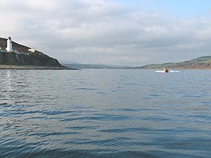
(c) Johnny Durnan, CC BY-SA 2.0 Campbeltown Loch in Blickrichtung Westen. Links ist die Insel Davaar mit Leuchtturm zu sehen. | ||
| Gewässer | Kilbrannan-Sund | |
| Landmasse | Kintyre | |
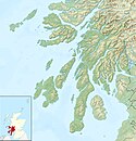
| Geographische Lage | 55° 25′ 15″ N, 5° 34′ 40″ W | |
| ||
| Inseln | Davaar | |
Campbeltown Loch ist eine Meeresbucht an der Südostküste der Halbinsel Kintyre in Schottland. An ihrem Kopf liegt die Stadt Campbeltown, von der sich ihr Name ableitet; inmitten der Einfahrt liegt die unbewohnte Gezeiteninsel Davaar. Campbeltown Loch öffnet sich nach Osten zum Kilbrannan-Sund, einem Nebenarm des Firth of Clyde hin.[1] Die Bucht reicht etwa drei Kilometer ins Land hinein und weist eine maximale Weite von etwa 1,5 km auf. Campbeltown Loch ist den Gezeiten unterworfen. Bei Ebbe ist Davaar über "The Doirlinn", einen Kiesstreifen zu Fuß erreichbar.[2] Südlich des Campbeltown Loch beginnt die Mull of Kintyre.
Einzelnachweise
- ↑ Eintrag im Gazetteer for Scotland
- ↑ N. Wilson, A. Murphy: Scotland, Lonely Planet, 5. Auflage, 2008, S. 322. ISBN 978-1-741-04725-7
Weblinks
Auf dieser Seite verwendete Medien
(c) Oliver Dixon, CC BY-SA 2.0
The Doirlinn The head of Kildalloig Bay drains at low tide, and for three hours either side of low water it is possible to walk out to Island Davaar. Here, two people are walking away from the island.
Contains Ordnance Survey data © Crown copyright and database right, CC BY-SA 3.0
Relief map of Argyll and Bute, UK.
Equirectangular map projection on WGS 84 datum, with N/S stretched 175%
Geographic limits:
- West: 7.2W
- East: 4.5W
- North: 56.8N
- South: 55.2N
(c) Johnny Durnan, CC BY-SA 2.0
Campbeltown Loch. Entrance to Campbeltown Loch with Davaar Island and lighthouse to the left.


