California State Route 4
 | ||||||||||||||||||||||||||||
|---|---|---|---|---|---|---|---|---|---|---|---|---|---|---|---|---|---|---|---|---|---|---|---|---|---|---|---|---|
| Karte | ||||||||||||||||||||||||||||
 | ||||||||||||||||||||||||||||
| Basisdaten | ||||||||||||||||||||||||||||
| Gesamtlänge: | 317 km (197 Meilen) | |||||||||||||||||||||||||||
| Eröffnung: | 1934 | |||||||||||||||||||||||||||
| Anfangspunkt: | ||||||||||||||||||||||||||||
| Endpunkt: | ||||||||||||||||||||||||||||
| Countys: | Contra Costa San Joaquin Stanislaus Calaveras Alpine | |||||||||||||||||||||||||||
| Wichtige Städte: | Hercules Concord Pittsburg Antioch Stockton | |||||||||||||||||||||||||||
Verlauf
| ||||||||||||||||||||||||||||
Die California State Route 4 (kurz CA 4) ist eine State Route im Bundesstaat Kalifornien der Vereinigten Staaten, die in West-Ost-Richtung verläuft. Die Straße verbindet die Stadt Hercules an der Bucht von San Pablo mit der California State Route 89 im Osten des Bundesstaats auf einer Strecke von etwa 317 km.
Verlauf


Die CA 4 beginnt vierspurig mit zwei getrennten Fahrstreifen an der Interstate 80 in der San Francisco Bay Area und führt von dort nach Osten. Sie kreuzt daraufhin die I-680 und verläuft nördlich der Stadt Concord entlang der Suisun Bay. Hinter der Stadt Antioch biegt die Straße für einige Kilometer nach Süden ab, um das Sacramento-San Joaquin River Delta zu umfahren, ehe sie wieder in östliche Richtung führt. Ab Brentwood wird die CA 4 dabei nur noch zweispurig. Bei Stockton kreuzt sie den San Joaquin River und die Interstate 5. Ab hier verläuft die California State Route 4 weiter durch eher ländliches Gebiet bis zur Westseite der Sierra Nevada. Ab dort schwenkt die Straße in nordöstliche Richtung und führt über den Ebbetts Pass über das Gebirge, wo sie bis zu 2663 m Höhe erreicht. Nach dem Pass mündet die Straße nahe der Grenze zu Nevada südlich des Lake Tahoe in die California State Route 89.
Siehe auch
Weblinks
Auf dieser Seite verwendete Medien
Autobahnkreuz (Icon) in blau.
Vector image of a 24 in by 25 in (600 mm by 635 mm) California State Route shield. Colors are from [1] (Pantone Green 342), converted to RGB by [2]. The outside border has a width of 1 (1/16 in) and a color of black so it shows up; in reality, signs have no outside border.
California State Route 89 shield.
oriented mountain pass symbol : n ne e se
Vector image of a 24 in by 25 in (600 mm by 635 mm) California State Route shield. Colors are from [1] (Pantone Green 342), converted to RGB by [2]. The outside border has a width of 1 (1/16 in) and a color of black so it shows up; in reality, signs have no outside border.
This is a map of State Route 4 in California.
Vector image of a 24 in by 25 in (600 mm by 635 mm) California State Route shield. Colors are from [1] (Pantone Green 342), converted to RGB by [2]. The outside border has a width of 1 (1/16 in) and a color of black so it shows up; in reality, signs have no outside border.
Vector image of a 24 in by 25 in (600 mm by 635 mm) California State Route shield. Colors are from [1] (Pantone Green 342), converted to RGB by [2]. The outside border has a width of 1 (1/16 in) and a color of black so it shows up; in reality, signs have no outside border.
Autor/Urheber: akampfer, Lizenz: CC BY-SA 3.0
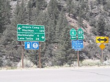
Intersection of California State Routes 4 & 89.
Zeichen "Einmündende Straße von rechts"
Autor/Urheber: akampfer, Lizenz: CC BY-SA 3.0
California State Route 4 at Ebbetts Pass.
600 mm by 600 mm (24 in by 24 in) Interstate shield, made to the specifications of the 2004 edition of Standard Highway Signs (sign M1-1). Uses the Roadgeek 2005 fonts. (United States law does not permit the copyrighting of typeface designs, and the fonts are meant to be copies of a U.S. Government-produced work anyway.) Colors are from [1] (Pantone Red 187 and Blue 294), converted to RGB by [2]. The outside border has a width of 1 (1 mm) and a color of black so it shows up; in reality, signs have no outside border.


