California State Route 14
 | |||||||||||||||||||||||||||||||||||||||||||||||||||||||||||||||||||||||||||||||||||||||||||||||||||||||||||||||||||
|---|---|---|---|---|---|---|---|---|---|---|---|---|---|---|---|---|---|---|---|---|---|---|---|---|---|---|---|---|---|---|---|---|---|---|---|---|---|---|---|---|---|---|---|---|---|---|---|---|---|---|---|---|---|---|---|---|---|---|---|---|---|---|---|---|---|---|---|---|---|---|---|---|---|---|---|---|---|---|---|---|---|---|---|---|---|---|---|---|---|---|---|---|---|---|---|---|---|---|---|---|---|---|---|---|---|---|---|---|---|---|---|---|---|---|---|
| Karte | |||||||||||||||||||||||||||||||||||||||||||||||||||||||||||||||||||||||||||||||||||||||||||||||||||||||||||||||||||
 | |||||||||||||||||||||||||||||||||||||||||||||||||||||||||||||||||||||||||||||||||||||||||||||||||||||||||||||||||||
| Basisdaten | |||||||||||||||||||||||||||||||||||||||||||||||||||||||||||||||||||||||||||||||||||||||||||||||||||||||||||||||||||
| Gesamtlänge: | 118 mi/190 km | ||||||||||||||||||||||||||||||||||||||||||||||||||||||||||||||||||||||||||||||||||||||||||||||||||||||||||||||||||
| Anfangspunkt: | |||||||||||||||||||||||||||||||||||||||||||||||||||||||||||||||||||||||||||||||||||||||||||||||||||||||||||||||||||
| Endpunkt: | |||||||||||||||||||||||||||||||||||||||||||||||||||||||||||||||||||||||||||||||||||||||||||||||||||||||||||||||||||
| Countys: | Los Angeles County Kern County | ||||||||||||||||||||||||||||||||||||||||||||||||||||||||||||||||||||||||||||||||||||||||||||||||||||||||||||||||||
| Wichtige Städte: | Palmdale Lancaster Mojave California City | ||||||||||||||||||||||||||||||||||||||||||||||||||||||||||||||||||||||||||||||||||||||||||||||||||||||||||||||||||
Verlauf
| |||||||||||||||||||||||||||||||||||||||||||||||||||||||||||||||||||||||||||||||||||||||||||||||||||||||||||||||||||
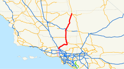
Die California State Route 14 (kurz CA 14) ist eine State Route im US-Bundesstaat Kalifornien, die in Nord-Süd-Richtung verläuft.
Die State Route beginnt an der Interstate 5 nahe Santa Clarita und endet nahe Inyokern am U.S. Highway 395. Sie verläuft durch die Mojave-Wüste und ist deshalb als High Desert bekannt. Zusammen mit dem U.S. 395 verbindet sie die das Greater Los Angeles Area mit großen Orten wie Reno. Während der südliche Teil der Straße durch ländliche Schluchten und Vororten führt, bietet der nördliche Abschnitt eine gute Sicht auf die Sierra Nevada-Bergkette. Teilweise verläuft die State Route durch wüstenartiges Gebiet und besonders um Mojave durch sehr dünn besiedeltes Gebiet.
Am 13. Oktober 2007 gab es einen schweren Unfall mit mehreren Toten und Verletzten am Newhall Pass Interchange mit der Interstate 5. Die Unfallstelle lag etwa 48 km nördlich der Innenstadt von Los Angeles, in einem etwa 170 m langen Umgehungstunnel für LKWs.[1]

Quellen
- ↑ New York Times: Pileup in California Freeway Tunnel Kills at Least 3, 14. Oktober 2007
Siehe auch
Weblinks
- California @ AA Roads Streckenbeschreibung mit Fotos (englisch)
- California Highway
Auf dieser Seite verwendete Medien
Autokreuzung (Icon) in grün.
28 in by 24 in (711 mm by 610 mm) California-style U.S. Route shield, made to the specifications of the 2002 edition of Standard Highway Signs with 10 in (250 mm) numerals. Uses the Roadgeek fonts. (United States law does not permit the copyrighting of typeface designs, and the fonts are meant to be copies of a U.S. Government-produced work anyway.)
Autobahnkreuz (Icon) in blau.
Vector image of a 24 in by 25 in (600 mm by 635 mm) California State Route shield. Colors are from [1] (Pantone Green 342), converted to RGB by [2]. The outside border has a width of 1 (1/16 in) and a color of black so it shows up; in reality, signs have no outside border.
This is a map of California State Route 14 in Southern California, with unconstructed parts in purple.
Vector image of a 24 in by 25 in (600 mm by 635 mm) California State Route shield. Colors are from [1] (Pantone Green 342), converted to RGB by [2]. The outside border has a width of 1 (1/16 in) and a color of black so it shows up; in reality, signs have no outside border.
Vector image of a 24 in by 25 in (600 mm by 635 mm) California State Route shield. Colors are from [1] (Pantone Green 342), converted to RGB by [2]. The outside border has a width of 1 (1/16 in) and a color of black so it shows up; in reality, signs have no outside border.
Autor/Urheber: Davemeistermoab, Lizenz: CC BY-SA 3.0
The northern terminus of California State Route 14 near w:Inyokern, California. Prior to 1964, this was the separation of US 395 and US 6.
Vector image of a 24 in by 25 in (600 mm by 635 mm) California State Route shield. Colors are from [1] (Pantone Green 342), converted to RGB by [2]. The outside border has a width of 1 (1/16 in) and a color of black so it shows up; in reality, signs have no outside border.


