California State Route 111
 | ||||||||||||||||||||||||||||||||||||||||||||||||||||||||||||||||||||||||||||||||||||||||||||||||||||||||||||||||||||||||||||||||||||||||||||||||||||||||||||||||||||||||||||||||||||||||||||||
|---|---|---|---|---|---|---|---|---|---|---|---|---|---|---|---|---|---|---|---|---|---|---|---|---|---|---|---|---|---|---|---|---|---|---|---|---|---|---|---|---|---|---|---|---|---|---|---|---|---|---|---|---|---|---|---|---|---|---|---|---|---|---|---|---|---|---|---|---|---|---|---|---|---|---|---|---|---|---|---|---|---|---|---|---|---|---|---|---|---|---|---|---|---|---|---|---|---|---|---|---|---|---|---|---|---|---|---|---|---|---|---|---|---|---|---|---|---|---|---|---|---|---|---|---|---|---|---|---|---|---|---|---|---|---|---|---|---|---|---|---|---|---|---|---|---|---|---|---|---|---|---|---|---|---|---|---|---|---|---|---|---|---|---|---|---|---|---|---|---|---|---|---|---|---|---|---|---|---|---|---|---|---|---|---|---|---|---|---|---|---|
| Karte | ||||||||||||||||||||||||||||||||||||||||||||||||||||||||||||||||||||||||||||||||||||||||||||||||||||||||||||||||||||||||||||||||||||||||||||||||||||||||||||||||||||||||||||||||||||||||||||||
 | ||||||||||||||||||||||||||||||||||||||||||||||||||||||||||||||||||||||||||||||||||||||||||||||||||||||||||||||||||||||||||||||||||||||||||||||||||||||||||||||||||||||||||||||||||||||||||||||
| Basisdaten | ||||||||||||||||||||||||||||||||||||||||||||||||||||||||||||||||||||||||||||||||||||||||||||||||||||||||||||||||||||||||||||||||||||||||||||||||||||||||||||||||||||||||||||||||||||||||||||||
| Gesamtlänge: | 129 mi/208 km | |||||||||||||||||||||||||||||||||||||||||||||||||||||||||||||||||||||||||||||||||||||||||||||||||||||||||||||||||||||||||||||||||||||||||||||||||||||||||||||||||||||||||||||||||||||||||||||
| Anfangspunkt: | US-Mexikanische Grenze in Calexico | |||||||||||||||||||||||||||||||||||||||||||||||||||||||||||||||||||||||||||||||||||||||||||||||||||||||||||||||||||||||||||||||||||||||||||||||||||||||||||||||||||||||||||||||||||||||||||||
| Endpunkt: | ||||||||||||||||||||||||||||||||||||||||||||||||||||||||||||||||||||||||||||||||||||||||||||||||||||||||||||||||||||||||||||||||||||||||||||||||||||||||||||||||||||||||||||||||||||||||||||||
| Countys: | Imperial Riverside | |||||||||||||||||||||||||||||||||||||||||||||||||||||||||||||||||||||||||||||||||||||||||||||||||||||||||||||||||||||||||||||||||||||||||||||||||||||||||||||||||||||||||||||||||||||||||||||
Verlauf
| ||||||||||||||||||||||||||||||||||||||||||||||||||||||||||||||||||||||||||||||||||||||||||||||||||||||||||||||||||||||||||||||||||||||||||||||||||||||||||||||||||||||||||||||||||||||||||||||
Die California State Route 111 (kurz CA 111) ist eine State Route im US-Bundesstaat Kalifornien, die in Nord-Süd-Richtung durch das Coachella Valley von Palm Springs nach Calexico verläuft.
Verlauf

Die State Route beginnt südlich von Calexico an der mexikanischen Grenze und trifft im Zentrum der Stadt auf die California State Route 98. Ab Calexico verläuft sie in nördlicher Richtung. Östlich von Heber zweigt die State Route 86 ab, bevor die CA 111 die Interstate 8 passiert. Ab der Interstate führt sie parallel zur CA 86 und zur CA 115 in nördlicher Richtung.
In Brawley kreuzt sie die California State Route 78 und in Calipatria endet die State Route 115 an ihr. Im Anschluss verläuft sie am nordöstlichen Ufer des Saltonsees entlang und trifft bei Mecca auf die California State Route 86S.
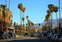
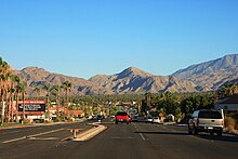
Im Osten von Indio nutzt sie für einige Kilometer die Trasse der State Route 86. Nach der Abzweigung der California State Route 74 im Süden von Palm Desert verläuft die CA 111 in nordwestlicher Richtung und endet nach der Durchquerung der Städte Rancho Mirage, Cathedral City und Palm Springs westlich von White Water an der Interstate 10.
Siehe auch
Weblinks
- California @ AA Roads Streckenbeschreibung mit Fotos (englisch)
- California Highways (englisch)
Auf dieser Seite verwendete Medien
Autobahnkreuz (Icon) in blau.
Autokreuzung (Icon) in grün.
600 mm by 300 mm (24 in by 12 in) south plate with small letters, made to the specifications of the 2004 edition of Standard Highway Signs (sign M3-3). Uses the Roadgeek 2005 fonts. (United States law does not permit the copyrighting of typeface designs, and the fonts are meant to be copies of a U.S. Government-produced work anyway.) Colors are from [1] (Pantone Green 342), converted to RGB by [2]. The outside border has a width of 1 (1 mm) and a color of black so it shows up; in reality, signs have no outside border.
Autor/Urheber: Patrick Pelster, Lizenz: CC BY-SA 3.0
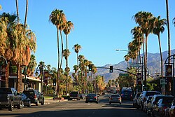
Blick nach Süden auf dem Palm Canyon Drive (California State Route 111) in Downtown Palm Springs, Kalifornien.
Shield for California State Route 74, located in Southern California.
Vector image of a 24 in by 25 in (600 mm by 635 mm) California State Route shield.
Vector image of a 24 in by 25 in (600 mm by 635 mm) California State Route shield. Colors are from [1] (Pantone Green 342), converted to RGB by [2]. The outside border has a width of 1 (1/16 in) and a color of black so it shows up; in reality, signs have no outside border.
Vector image of a 24 in by 25 in (600 mm by 635 mm) California State Route shield. Colors are from [1] (Pantone Green 342), converted to RGB by [2]. The outside border has a width of 1 (1/16 in) and a color of black so it shows up; in reality, signs have no outside border.
Autor/Urheber: Patrick Pelster, Lizenz: CC BY-SA 3.0
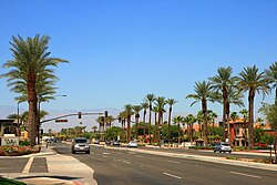
Kreuzung von Rancho Las Palmas Drive und California State Route 111 in Rancho Mirage, Kalifornien.
Vector image of a 24 in by 25 in (600 mm by 635 mm) California State Route shield. Colors are from [1] (Pantone Green 342), converted to RGB by [2]. The outside border has a width of 1 (1/16 in) and a color of black so it shows up; in reality, signs have no outside border.
Vector image of a 24 in by 25 in (600 mm by 635 mm) California State Route shield. Colors are from [1] (Pantone Green 342), converted to RGB by [2]. The outside border has a width of 1 (1/16 in) and a color of black so it shows up; in reality, signs have no outside border.
This is a map of State Route 111 in California, with recently-relinquished parts in pink.
600 mm by 300 mm (24 in by 12 in) east plate with small letters, made to the specifications of the 2004 edition of Standard Highway Signs (sign M3-2). Uses the Roadgeek 2005 fonts. (United States law does not permit the copyrighting of typeface designs, and the fonts are meant to be copies of a U.S. Government-produced work anyway.) Colors are from [1] (Pantone Green 342), converted to RGB by [2]. The outside border has a width of 1 (1 mm) and a color of black so it shows up; in reality, signs have no outside border.
600 mm by 300 mm (24 in by 12 in) west plate with small letters, made to the specifications of the 2004 edition of Standard Highway Signs (sign M3-4). Uses the Roadgeek 2005 fonts. (United States law does not permit the copyrighting of typeface designs, and the fonts are meant to be copies of a U.S. Government-produced work anyway.) Colors are from [1] (Pantone Green 342), converted to RGB by [2]. The outside border has a width of 1 (1 mm) and a color of black so it shows up; in reality, signs have no outside border.
Vector image of a 24 in by 25 in (600 mm by 635 mm) California State Route shield. Colors are from [1] (Pantone Green 342), converted to RGB by [2]. The outside border has a width of 1 (1/16 in) and a color of black so it shows up; in reality, signs have no outside border.
Vector image of a 24 in by 25 in (600 mm by 635 mm) California State Route shield. Colors are from [1] (Pantone Green 342), converted to RGB by [2]. The outside border has a width of 1 (1/16 in) and a color of black so it shows up; in reality, signs have no outside border.
Autor/Urheber: Patrick Pelster, Lizenz: CC BY-SA 3.0
Blick auf Cathedral City und Palm Desert im Coachella Valley, gesehen von der California State Route 111 (Palm Canyon Drive) östlich von Palm Springs, Kalifornien.


