Cabrillo National Monument
| Cabrillo National Monument | |||
|---|---|---|---|
 | |||
| |||
| Lage: | Kalifornien, Vereinigte Staaten | ||
| Nächste Stadt: | San Diego | ||
| Fläche: | 0,6 km² | ||
| Gründung: | 14. Oktober 1913 | ||
| Besucher: | 826.615 (2005) | ||
 | |||
Das Cabrillo National Monument im US-Bundesstaat Kalifornien wurde zu Ehren von Juan Rodríguez Cabrillo errichtet, der am 28. September 1542 als erster Europäer an der Westküste Nordamerikas landete. Das Monument erhielt 1913 den Status als National Monument. Am 15. Oktober 1966 wurde es als Historic District in das National Register of Historic Places aufgenommen.[1]
1939 fertigte der Bildhauer Alvaro de Bree eine Statue Cabrillos im Auftrag der portugiesischen Regierung an, die die Statue den Vereinigten Staaten schenkte. Die Statue ist über vier Meter hoch und wiegt circa sieben Tonnen.
Jedes Jahr im Oktober findet das Cabrillo Festival statt, welches die Landung am Ballast Point in der Bucht von San Diego wiederholt.
Vom Park aus ist der Hafen und die Skyline von San Diego und von Coronado zu sehen.
Auf der höchsten Erhebung des Parks steht die Leuchtturmanlage Old Point Loma Light Station, ein Symbol San Diegos seit 1855. Von dem Leuchtturm aus sind im Winter Grauwale zu beobachten.
Galerie
 Old Point Loma Light Station
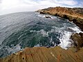 Tide Pool Area
Siehe auch
Weblinks
- National Park Service: Cabrillo National Monument (offizielle Seite; englisch)
- Westküste USA: Cabrillo NM und Old Point Loma Lighthouse Ausführliche Beschreibung der Sehenswürdigkeiten mit vielen Fotos (dt.)
Einzelnachweise
- ↑ Eintrag im National Register Information System. National Park Service, abgerufen am 20. Mai 2016
Admiralty Island | African Burial Ground | Agate Fossil Beds | Agua Fria | Aleutian Islands World War II | Alibates Flint Quarries | Aniakchak | Aztec Ruins | Bandelier | Basin and Range | Bears Ears | Belmont-Paul Women’s Equality | Berryessa Snow Mountain | Birmingham Civil Rights | Booker T. Washington | Browns Canyon | Buck Island Reef | Cabrillo | California Coastal | Camp Hale - Continental Divide | Camp Nelson Heritage | Canyon De Chelly | Canyons of the Ancients | Cape Krusenstern | Capulin Volcano | Carrizo Plain | Casa Grande Ruins | Cascade-Siskiyou | Castillo de San Marcos | Castle Clinton | Castle Mountains | Cedar Breaks | César E. Chávez | Charles Young Buffalo Soldiers | Chimney Rock | Chiricahua | Colorado | Craters of the Moon | Devils Postpile | Devils Tower | Dinosaur | Effigy Mounds | El Malpais | El Morro | Florissant Fossil Beds | Fort Frederica | Fort Matanzas | Fort McHenry | Fort Monroe | Fort Ord | Fort Pulaski | Fort Stanwix | Fort Union | Fossil Butte | Freedom Riders | George Washington Birthplace | George Washington Carver | Giant Sequoia | Gila Cliff Dwellings | Gold Butte | Governors Island | Grand Canyon-Parashant | Grand Portage | Grand Staircase-Escalante | Hagerman Fossil Beds | Hanford Reach | Harriet Tubman Underground Railroad | Hohokam Pima | Hovenweep | Ironwood Forest | Jewel Cave | John Day Fossil Beds | Jurassic | Kasha-Katuwe Tent Rocks | Katahdin Woods and Waters | Lava Beds | Little Bighorn Battlefield | Marianas Trench | Medgar and Myrlie Evers Home | Military Working Dog Teams | Mill Springs Battlefield | Misty Fjords | Mojave Trails | Montezuma Castle | Mount St. Helens | Muir Woods | Natural Bridges | Navajo | Newberry | Northeast Canyons and Seamounts | Oregon Caves | Organ Mountains-Desert Peaks | Organ Pipe Cactus | Pacific Remote Islands | Papahānaumokuākea | Petroglyph | Pipe Spring | Pipestone | Pompeys Pillar | Poverty Point | Prehistoric Trackways | President Lincoln and Soldiers’ Home | Rainbow Bridge | Río Grande del Norte | Rose Atoll | Russell Cave | Saint Francis Dam Disaster | Salinas Pueblo Missions | San Gabriel Mountains | San Juan Islands | Sand to Snow | Santa Rosa and San Jacinto Mountains | Scotts Bluff | Sonoran Desert | Statue of Liberty | Stonewall | Sunset Crater | Timpanogos Cave | Tonto | Tule Lake | Tule Springs Fossil Beds | Tuzigoot | Upper Missouri River Breaks | Vermilion Cliffs | Virgin Islands Coral Reef | Waco Mammoth | Walnut Canyon | Wupatki | Yucca House
Auf dieser Seite verwendete Medien
_location_map.svg)
Autor/Urheber: TUBS
Location map of the USA (Hawaii and Alaska shown in sidemaps).
Main map: EquiDistantConicProjection : Central parallel :
* N: 37.0° N
Central meridian :
* E: 96.0° W
Standard parallels:
* 1: 32.0° N
* 2: 42.0° N
Made with Natural Earth. Free vector and raster map data @ naturalearthdata.com.
Formulas for x and y:
x = 50.0 + 124.03149777329222 * ((1.9694462586094064-({{{2}}}* pi / 180))
      * sin(0.6010514667026994 * ({{{3}}} + 96) * pi / 180))
y = 50.0 + 1.6155950752393982 * 124.03149777329222 * 0.02613325650382181
      - 1.6155950752393982  * 124.03149777329222 *
     (1.3236744353715044  - (1.9694462586094064-({{{2}}}* pi / 180))
      * cos(0.6010514667026994 * ({{{3}}} + 96) * pi / 180))
Hawaii side map: Equirectangular projection, N/S stretching 107 %. Geographic limits of the map:
- N: 22.4° N
- S: 18.7° N
- W: 160.7° W
- E: 154.6° W
Alaska side map: Equirectangular projection, N/S stretching 210.0 %. Geographic limits of the map:
- N: 72.0° N
- S: 51.0° N
- W: 172.0° E
- E: 129.0° W

Autor/Urheber: Wasquewhat, Lizenz: CC BY-SA 4.0
Cabrillo, San Diego, CA, USA, Cliffs
Autor/Urheber: Der-wuppertaler, Lizenz: CC BY-SA 3.0
Statue of Juan Rodriguez Cabrillo, the first European who reached the US west coast, at Point Loma in San Diego

Autor/Urheber: Frank Schulenburg, Lizenz: CC BY-SA 4.0
Old Point Loma Light Station on the Point Loma peninsula at the mouth of San Diego Bay in San Diego, California, United States, in April 2019

Map of Cabrillo National Monument