Cabin John
| Cabin John | |
|---|---|
 Cabin John Bridge | |
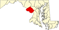
| Lage in Maryland | |
| Basisdaten | |
| Staat: | Vereinigte Staaten |
| Bundesstaat: | Maryland |
| County: | Montgomery County |
| Koordinaten: | 38° 59′ N, 77° 10′ W |
| Zeitzone: | Eastern (UTC−5/−4) |
| Einwohner: | 2.459 (Stand: 2020) |
| Haushalte: | 880 (Stand: 2020) |
| Fläche: | 3,4 km² (ca. 1 mi²) davon 2,5 km² (ca. 1 mi²) Land |
| Bevölkerungsdichte: | 984 Einwohner je km² |
| Höhe: | 52 m |
| Postleitzahl: | 20818 |
| Vorwahl: | +1 301 |
| FIPS: | 24-12075 |
| GNIS-ID: | 0589873 |
Cabin John ist ein Census-designated place im Montgomery County im US-Bundesstaat Maryland. Das U.S. Census Bureau hat bei der Volkszählung 2020 eine Einwohnerzahl von 2459[1] ermittelt.
Die Siedlung mit ursprünglichem Namen Captain John's Mills liegt innerhalb der Metropolregion nordwestlich von Washington, D.C. am nördlichen Ufer des Potomac River.
Weblinks
Einzelnachweise
- ↑ US Census Bureau: Search Results Total Population in Cabin John CDP, Maryland. Abgerufen am 16. Januar 2024 (amerikanisches Englisch).
Auf dieser Seite verwendete Medien
Locator map of Montgomery County — in Maryland, adjacent to the Potomac River and Washington, D.C.
- Credits
- David Benbennick made this map.
- For more information, see Commons:United States county locator maps.
View of Union Arch Bridge, Cabin John, Maryland, USA. The Cabin John Parkway is seen running underneath the bridge.
Autor/Urheber: Arkyan, Lizenz: CC BY-SA 3.0
This map shows the incorporated and unincorporated areas in Montgomery County, Maryland, highlighting Cabin John in red. It was created with a custom script with US Census Bureau data and modified with Inkscape.


