Bush Mountains
| Bush Mountains | ||
|---|---|---|
| Lage | Ross Dependency, Antarktika | |
| Teil des | Königin-Maud-Gebirges im Transantarktischen Gebirge | |
| ||
| Koordinaten | 84° 57′ S, 179° 30′ O | |
Die Bush Mountains umfassen eine Reihe schroffer Berghöhen in der antarktischen Ross Dependency. Im Transantarktischen Gebirge erheben sich diese an den Kopfenden des Ramsey- und des Kosco-Gletschers und reichen vom Mount Weir im Westen bis zu den Anderson Heights oberhalb des Shackleton-Gletschers im Osten.
Das Gebirge wurde bei mehreren Flügen im November 1929 bei der Byrd Antarctic Expedition (1928–1930) zum Königin-Maud-Gebirge aus der Entfernung fotografiert. Weiteren Aufschluss ergaben Luftaufnahmen, die bei der United States Antarctic Service Expedition (1939–1941) entstanden, sowie diejenigen der Operation Highjump (1946–1947) und der Deep Freeze Operationen zwischen 1956 und 1963. Das Advisory Committee on Antarctic Names benannte das Gebirge auf Vorschlag des US-amerikanischen Polarforschers Richard Evelyn Byrd 1947 nach James I. Bush (1885–1961), US-amerikanischer Finanzinvestor und Sponsor der Byrd Antarctic Expedition.
Weblinks
- Bush Mountains. In: Geographic Names Information System. United States Geological Survey, United States Department of the Interior, archiviert vom (englisch).
- Bush Mountains auf geographic.org (englisch)
 Westteil ganz im Südosten der Karte
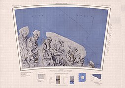 Ostteil im südwestlichen Viertel der Karte
Auf dieser Seite verwendete Medien

Autor/Urheber: Alexrk2, Lizenz: CC BY-SA 3.0
Physische Positionskarte Antarktis, Mittabstandstreue Azimutalprojektion

1:250,000-scale topographic reconnaissance map of the Shackleton Glacier and Prince Olav Mountains (Queen Maud Mountains) area from 180°-165°W to 84°-85°S in Antarctica. Mapped, edited and published by the U.S. Geological Survey in cooperation with the National Science Foundation.

1:250,000-scale topographic reconnaissance map of the Queen Alexandra Range and Queen Maud Mountains area from 165°-180'E to 84°-85°S in Antarctica. Mapped, edited and published by the U.S. Geological Survey in cooperation with the National Science Foundation.