Buckingham Island
| Buckingham Island | ||
|---|---|---|
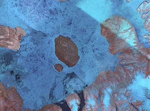
| Norwegian Bay mit Graham Island und südwestlich davon Buckingham Island | ||
| Gewässer | Norwegian Bay | |
| Inselgruppe | Königin-Elisabeth-Inseln | |
| Geographische Lage | 77° 12′ N, 91° 0′ W | |
| Länge | 15 km | |
| Breite | 11 km | |
| Fläche | 137 km² | |
| Höchste Erhebung | Mount Windsor 150 m | |
| Einwohner | unbewohnt | |
| Lage von Buckingham Island in der Norwegian Bay | ||
Buckingham Island ist eine der Königin-Elisabeth-Inseln in Nunavut, Kanada.
Geografie
Die Insel liegt in der Norwegian Bay südwestlich der größeren Insel Graham Island, von der sie durch einen an der schmalsten Stelle 4 km breiten Kanal getrennt ist. Die Entfernung zur südsüdöstlich gelegenen Insel North Kent Island beträgt 38 km, die zur nordwestlich gelegenen Insel Cornwall Island 60 km. Buckingham Island ist von ovaler Gestalt ohne auffällige Kaps. Das Land steigt von den Küsten sanft bis zum zentral gelegenen, 150 m hohen Mount Windsor an. Buckingham Island ist etwa 15 km lang und 11 km breit. Die Insel besitzt eine Fläche von 137 km².[1]
Buckingham Island ist bekannt für das hier auftretende Phänomen der Solifluktion, das 1855 erstmals beschrieben wurde.[2][3]
Geschichte
Die Insel wurde im Juni 1852 von einer Suchexpedition nach dem vermissten John Franklin entdeckt, die unter dem Kommando von Edward Belcher stand. Er benannte sie nach dem königlichen Buckingham Palace in London, ihren höchsten Punkt nach Windsor Castle.[4]
1900 wurde die Insel von Otto Sverdrups Zweiter Norwegischer Fram-Expedition (1898–1902) erforscht und kartiert.[5]
Einzelnachweise
- ↑ The Atlas of Canada – Sea Islands (Memento vom 6. Oktober 2012 im Internet Archive) (englisch)
- ↑ Richard J. Chorley: The History of the Study of Landforms Or the Development of Geomorphology: Quaternary and Recent Processes and Forms (1890–1965) and the Mid-century Revolutions. The Geological Society Publishing House, Bath 2008, S. 193 (englisch)
- ↑ Edward Belcher: The last of the Arctic voyages being a narrative of the expedition in H. M. S. Assistance, under the command of Captain Sir Edward Belcher, C. B., in search of Sir John Franklin during the years 1852–53–54. Band 1, Lovell Reeve, London 1855, S. 307f (englisch)
- ↑ Edward Belcher: The last of the Arctic voyages being a narrative of the expedition in H. M. S. Assistance, under the command of Captain Sir Edward Belcher, C. B., in search of Sir John Franklin during the years 1852–53–54. Band 1, Lovell Reeve, London 1855, S. 309 (englisch)
- ↑ Otto Sverdrup: New Land. Band 1, Longmans, Green & Co., London 1904, S. 475 (englisch)
Weblinks
- Graham Island (mit Buckingham Island) (Memento vom 23. Februar 2012 im Internet Archive) in der Insel-Enzyklopädie www.oceandots.com (englisch)
Auf dieser Seite verwendete Medien
Satellite picture of Graham Island, Nunavut, Canada
Autor/Urheber:
- Canada_Nunavut_location_map-lambert_proj.svg: Flappiefh
- derivative work: NordNordWest
Positionskarte von Nunavut, Kanada
Autor/Urheber: Kelisi at en.wikipedia, Lizenz: CC BY-SA 3.0
Map of Graham and Buckingham Islands in Norwegian Bay, Nunavut, Canada.


