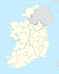
Boyle (Irland)
| Boyle Mainistir na Búille Boyle | ||
|---|---|---|
| ||
| Koordinaten | 53° 58′ N, 8° 18′ W | |
| Basisdaten | ||
| Staat | Irland | |
| Provinz | Connacht | |
| Grafschaft | Roscommon | |
| ISO 3166-2 | IE-RN | |
| Höhe | 83 m | |
| Einwohner | 2915 (2022[1]) | |
| Telefonvorwahl | +353 (0)71 | |
(c) Andreas F. Borchert, CC BY-SA 4.0 Kirchenschiffruine der Boyle Abbey | ||
Boyle (irisch Mainistir na Búille, lateinisch: Buellium)[2] ist eine irische Stadt im Norden des Countys Roscommon. Sie liegt am Fuße der Curlew Mountains in der Nähe der Seen Lough Key, Lough Arrow und Lough Gara auf einer Höhe von 83 m.
Die Einwohnerzahl beträgt 2915 (2022[1]). Boyle ist an den Schienenverkehr und an die Nationalstraße N4 von Dublin nach Sligo angeschlossen. Bekannt sind die Ruinen der Boyle Abbey. Drei Kilometer westlich von Boyle liegt das Portal Tomb von Drumanone.
Persönlichkeiten
- Maureen O’Sullivan (1911–1998), Schauspielerin
- Patrick Francis Sheehan (1932–2012), Bischof von Kano (Nigeria)
- Chris O’Dowd (* 1979), Schauspieler
Literatur
- Peter Harbison: Guide to the National and Historic Monuments of Ireland. Gill and Macmillan, Dublin 1992, ISBN 0-7171-1956-4, S. 208–209
Weblinks
- Website der Stadt (englisch)
Einzelnachweise
- ↑ a b Census 2022. citypopulation.de, abgerufen am 28. Juli 2023.
- ↑ Mainistir na Búille/Boyle. Abgerufen am 11. Mai 2023 (englisch).
Auf dieser Seite verwendete Medien
(c) Andreas F. Borchert, CC BY-SA 4.0
Boyle Abbey, County Roscommon, Ireland
Nave, looking East
Autor/Urheber:
- Island_of_Ireland_location_map.svg: *Ireland_location_map.svg: NordNordWest
- Northern_Ireland_location_map.svg: NordNordWest
- Northern_Ireland_-_Counties.png: Maximilian Dörrbecker (Chumwa)
- derivative work: Rannpháirtí anaithnid (talk)
- derivative work: Mabuska (talk)
The island of Ireland, showing international border between Northern Ireland and Republic of Ireland, traditional provinces, traditional counties, and local authority areas in the Republic of Ireland and Northern Ireland.
(c) Karte: NordNordWest, Lizenz: Creative Commons by-sa-3.0 de
Positionskarte von Irland


