Bouleternère
| Bouleternère | ||
|---|---|---|
 |
| |
| Staat | Frankreich | |
| Region | Okzitanien | |
| Département (Nr.) | Pyrénées-Orientales (66) | |
| Arrondissement | Prades | |
| Kanton | Le Canigou | |
| Gemeindeverband | Roussillon-Conflent | |
| Koordinaten | 42° 39′ N, 2° 35′ O | |
| Höhe | 160–612 m | |
| Fläche | 10,78 km² | |
| Einwohner | 943 (1. Januar 2018) | |
| Bevölkerungsdichte | 87 Einw./km² | |
| Postleitzahl | 66130 | |
| INSEE-Code | 66023 | |
| Website | https://www.bouleternere.fr/ | |
 Kirche Saint-Sulpice | ||
Bouleternère ist eine französische Gemeinde mit 943 Einwohnern (Stand 1. Januar 2018) im Département Pyrénées-Orientales in der Region Okzitanien. Sie gehört zum Arrondissement Prades und zum Kanton Le Canigou.
Geographie
Nachbargemeinden von Bouleternère sind Ille-sur-Têt im Nordosten, Saint-Michel-de-Llotes im Osten, Casefabre im Südosten, Boule-d’Amont im Süden und Rodès im Nordwesten.

Bevölkerungsentwicklung
| Jahr | 1962 | 1968 | 1975 | 1982 | 1990 | 1999 | 2013 |
| Einwohner | 818 | 885 | 739 | 728 | 625 | 643 | 906 |
Sehenswürdigkeiten
- Stadtmauer mit zwei Türmen und drei Toren
- Kapelle Sainte-Anne
- Kirche Saint-Nazaire in Barbadell
- Ehemalige Kirche Saint-Sulpice (11. Jahrhundert)
- Neue Kirche Saint-Sulpice (1659)
- Burg Belpuig (14. Jahrhundert)
- Kirche Saint-Étienne in Prunet
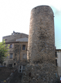
Turm der Stadtmauer

Turm der Stadtmauer

Portal der neuen Kirche Saint-Sulpice

Kirche Saint-Nazaire in Barbadell
Weblinks
Auf dieser Seite verwendete Medien

(c) Karte: NordNordWest, Lizenz: Creative Commons by-sa-3.0 de
Positionskarte von Frankreich mit Regionen und Départements
Autor/Urheber: ArnoLagrange, Lizenz: CC BY-SA 3.0
Église Saint-Sulpice à Bouleternère
Autor/Urheber:
|
Map data (c) OpenStreetMap contributors, CC-BY-SA _French_municipality_map.svg) • Shape files infrastructure: railway, highways, water: all originally by OpenStreetMap contributors. Status december 2011 *note: shown commune boundaries are from OSM dump May 2012; at that time about 90% complete |
Map of French municipality

Autor/Urheber: ArnoLagrange, Lizenz: CC BY-SA 3.0
Tour ronde de remparts à Bouleternère

Autor/Urheber: Jordi Roqué, Lizenz: CC BY-SA 3.0
Church of Sant Nazari de Barbadell (Bouleternère, Pyrénées-Orientales, France)

Autor/Urheber: ArnoLagrange, Lizenz: CC BY-SA 3.0
Église Saint-Sulpice à Bouleternère

Autor/Urheber: ArnoLagrange, Lizenz: CC BY-SA 3.0
Tour ronde de remparts à Bouleternère