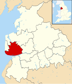
Borough of Fylde
| Borough of Fylde | |
|---|---|
Contains Ordnance Survey data © Crown copyright and database right, CC BY-SA 3.0 Lage in Lancashire | |
| Status | Borough |
| Region | North West |
| Verw.grafschaft | Lancashire |
| Verwaltungssitz | Lytham St Annes |
| Fläche | 165,53 km² (202.) |
| Einwohner | 75.757 (305.) |
| ONS-Code | 30UF |
| Website | www.fylde.gov.uk |
Fylde ist ein Verwaltungsbezirk mit dem Status eines Borough in der Grafschaft Lancashire in England. Im Jahr 2011 hatte es 120.684 Einwohner.[1] Verwaltungssitz ist die Stadt Lytham St Annes, mit einigen Abteilungen in Kirkham. Der Bezirk wurde am 1. April 1974 gebildet und entstand aus der Fusion des Borough of Lytham, des Urban District Kirkham und des Rural District Fylde.
Civil parishes
- Ansdell, Bryning-with-Warton, Elswick, Freckleton, Greenhalgh-with-Thistleton, Kirkham, Little Eccleston-with-Larbreck, Lytham, Medlar-with-Wesham, Newton-with-Clifton, Ribby-with-Wrea, Saint Anne’s on the Sea, Singleton, Staining, Treales, Roseacre and Wharles, Weeton-with-Preese und Westby-with-Plumptons.[2]
Anmerkungen
- ↑ Office for National Statistics: Area: Fylde (Local Authority). Neighbourhood Statistics, abgerufen am 1. Mai 2017 (englisch).
- ↑ Ordnance Survey: Fylde. Ordnance Survey Linked Data, abgerufen am 10. Mai 2017 (englisch).
Koordinaten: 53° 46′ N, 2° 56′ W
Auf dieser Seite verwendete Medien
(c) Gerald England, CC BY-SA 2.0
South Promenade. Looking down South Promenade, St Annes, towards Lytham. On the left are hotels and apartments. On the right are ornamental gardens with swans in pools.
Contains Ordnance Survey data © Crown copyright and database right, CC BY-SA 3.0
Map of Lancashire, UK with Fylde highlighted.
Equirectangular map projection on WGS 84 datum, with N/S stretched 165%


