Bongawan
| Bongawan | ||
|---|---|---|
| Koordinaten | 5° 32′ N, 115° 51′ O | |
| Basisdaten | ||
| Staat | Malaysia | |
| Bundesstaat | Sabah | |
| ISO 3166-2 | MY-12 | |
| Einwohner | 253 (2010[1]) | |
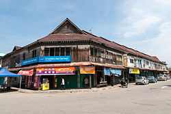
Photo by CEphoto, Uwe Aranas or alternatively © CEphoto, Uwe Aranas, CC BY-SA 3.0 Alte Ladengeschäfte im kolonialen Stil | ||
Bongawan ist eine Kommune im Westen des malaysischen Bundesstaats Sabah. Bongawan liegt in der West Coast Division, etwa 60 Kilometer südlich der Landeshauptstadt Kota Kinabalu. Verwaltungstechnisch gehört sie zum Distrikt Papar.
Demographie
Die Bevölkerung beträgt laut der letzten Volkszählung 253 Einwohner und setzt sich überwiegend aus Malaien und Chinesen zusammen.[1]
Etymologie
Der Name Bongawan leitet sich von „Bangau“ ab, der lokalen Bezeichnung für einen Silberreiher. Diese Vogelart ist auf den Reisfeldern der Umgebung häufig anzutreffen.
Sehenswürdigkeiten
Bongawan gehört zu den wenigen Kommunen, in denen sich die alten Ladengeschäfte aus der Zeit vor dem Zweiten Weltkrieg erhalten haben. Anders als in den größeren Städten, die durch japanische und alliierte Angriffe schwer zerstört wurden, haben die hölzernen Gebäude aus dem Jahr 1939 die Zeit überdauert. Die meisten Läden werden von Hakka und Hokkien geführt.
Infrastruktur
Bongawan ist mit einem Haltepunkt an die Eisenbahnstrecke Kota Kinabalu—Tenom der Sabah State Railway angebunden. Eine Zubringerstraße verbindet den Ort mit der Fernstraße A2 (Pan Borneo Highway).
Literatur
- W. H. Treacher: British Borneo – Sketches of Brunai, Sarawak, Labuan and North Borneo. Government print department, Singapore 1891; archive.org.
- Owen Rutter: British North Borneo – An Account of its History, Ressources and Native Tribes. Constable & Company, London 1922; archive.org.
- K. G. Tregonning: A History Of Modern Sabah (North Borneo 1881–1963). 2. Ausgabe. University of Malaya Press, Kuala Lumpur 1965, Reprint 1967.
Weblinks
Einzelnachweise
- ↑ a b statistics.gov.my: Population Distribution by Local Authority Areas and Mukims, 2010. (Memento vom 14. November 2013 im Internet Archive; PDF; 1,8 MB) Census 2010, S. 138.
Auf dieser Seite verwendete Medien
Photo by CEphoto, Uwe Aranas or alternatively © CEphoto, Uwe Aranas, CC BY-SA 3.0
Bongawan, Sabah: Historic shop lots and colonial architecture in Bongawan
Autor/Urheber: Uwe Dedering, Lizenz: CC BY-SA 3.0
Location map of Malaysia.
Equirectangular projection. Strechted by 100.0%. Geographic limits of the map:
* N: 8.0° N
* S: 0.0° N
* W: 99.0° E
* E: 120.0° E
Made with Natural Earth. Free vector and raster map data @ naturalearthdata.com.
Flag of the Malaysian state Sabah. Based on a GIF from a government website, colors from a photo. Drawn by Mysid. The flag was adopted September 16, 1988.
- The mountain on the left is Mount Kinabalu.
Per the Constitution of the State of Sabah:
"The State Flag is in a rectangular shape and is in the proportion of 1:2. The canton which extends at the head half way to the fly and 2/3 at the hoist to the foot is in Icicle Blue (C1T9) as the background to a graphic silhouette of Mount Kinabalu which is in Royal Blue (B10) positioned at ¼ of the height of the canton from end to end. The fly of the flag is divided equally into three bands of colours the foot division of which extends right to the hoist. The top band is in Zircon Blue (C5T5) the second band is in white and the third band is in Chili Red (S6R4)."Photo by CEphoto, Uwe Aranas or alternatively © CEphoto, Uwe Aranas, CC BY-SA 3.0
Sabah State Railway: Bongawan Railway Station


