Bloomingdale (Ohio)
| Bloomingdale | |
|---|---|
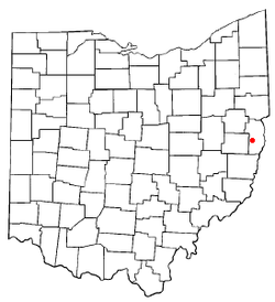
Karte von Ohio, Bloomingdale hervorgehoben | |
| Basisdaten | |
| Gründung: | 1816 |
| Staat: | Vereinigte Staaten |
| Bundesstaat: | Ohio |
| County: | Jefferson County |
| Koordinaten: | 40° 21′ N, 80° 49′ W |
| Zeitzone: | Eastern (UTC−5/−4) |
| Einwohner: | 145 (Stand: 2020) |
| Haushalte: | 57 (Stand: 2020) |
| Fläche: | 0,23 km² (ca. 0 mi²) davon 0,23 km² (ca. 0 mi²) Land |
| Bevölkerungsdichte: | 630 Einwohner je km² |
| Höhe: | 385 m |
| Postleitzahl: | 43910 |
| Vorwahl: | +1 740 |
| FIPS: | 39-07202 |
| GNIS-ID: | 1038125 |
Bloomingdale ist ein Village im Jefferson County des US-Bundesstaates Ohio. Im Jahr 2010 hatte Bloomingdale 202 Einwohner.
Geographie
Umgeben wird Bloomingdale von East Springfield und von Richmond im Norden und von Wintersville und Steubenville im Osten.
Auf dieser Seite verwendete Medien
Autor/Urheber: Der ursprünglich hochladende Benutzer war Catbar in der Wikipedia auf Englisch, Lizenz: CC BY-SA 3.0
Adapted from Wikipedia's OH county maps by Catbar.
Autor/Urheber: Ruhrfisch and Nyttend, Lizenz: CC BY-SA 3.0
Map of the municipal and township boundaries of Jefferson County, Ohio, United States, as of the 2000 census, with the location of the village of Bloomingdale highlighted. Township borders are shown only in unincorporated areas in order to differentiate incorporated and unincorporated areas more clearly.


