Blanco County
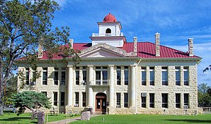
(c) Larry D. Moore, CC BY 4.0 | |
| Verwaltung | |
|---|---|
| US-Bundesstaat: | Texas |
| Verwaltungssitz: | Johnson City |
| Adresse des Verwaltungssitzes: | Blanco County Courthouse P.O. Box 65 Johnson City, TX 78636-0117 |
| Gründung: | 1858 |
| Gebildet aus: | Burnet County Comal County Gillespie County Hays County |
| Vorwahl: | 001 830 |
| Demographie | |
| Einwohner: | 11.374 (Stand: 2020) |
| Bevölkerungsdichte: | 6,17 Einwohner/km2 |
| Geographie | |
| Fläche gesamt: | 1848 km² |
| Wasserfläche: | 6 km² |
| Karte | |
 | |
| Website: www.co.blanco.tx.us | |
Das Blanco County[1] ist ein County im Bundesstaat Texas der Vereinigten Staaten. Das U.S. Census Bureau hat bei der Volkszählung 2020 eine Einwohnerzahl von 11.374[2] ermittelt. Der Sitz der County-Verwaltung (County Seat) befindet sich in Johnson City.[3]
Geographie
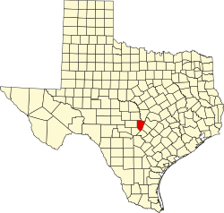
Das County liegt südöstlich des geographischen Zentrums von Texas und hat eine Fläche von 1848 Quadratkilometern, wovon 6 Quadratkilometer Wasserfläche sind. Es grenzt im Uhrzeigersinn an folgende Countys: Burnet County, Travis County, Hays County, Comal County, Kendall County, Gillespie County und Llano County. Neben dem Blanco State Park und dem Pedernales Falls State Park befinden sich Teile des Lyndon B. Johnson National Historical Park auf dem Gebiet des Countys.
Geschichte
Blanco County wurde am 12. Februar 1858 aus Teilen des Burnet County, Comal County, Gillespie County und Hays County gebildet. Benannt wurde es nach dem Blanco River. Dieser heißt nach dem Spanischen blanco (deutsch: „weiß“), weil kreidehaltiges Gestein für eine entsprechende Färbung des Flusses sorgt.[4]

Ein Ort im County hat den Status einer National Historic Landmark, das Lyndon Baines Johnson Boyhood Home.[5] Vier Bauwerke und Stätten des Countys sind im National Register of Historic Places (NRHP) eingetragen (Stand 1. Oktober 2018).[6]
Demografische Daten
| Bevölkerungswachstum | |||
|---|---|---|---|
| Census | Einwohner | ± rel. | |
| 1860 | 1.281 | — | |
| 1870 | 1.187 | −7,3 % | |
| 1880 | 3.583 | 201,9 % | |
| 1890 | 4.649 | 29,8 % | |
| 1900 | 4.703 | 1,2 % | |
| 1910 | 4.311 | −8,3 % | |
| 1920 | 4.063 | −5,8 % | |
| 1930 | 3.842 | −5,4 % | |
| 1940 | 4.264 | 11 % | |
| 1950 | 3.780 | −11,4 % | |
| 1960 | 3.657 | −3,3 % | |
| 1970 | 3.567 | −2,5 % | |
| 1980 | 4.681 | 31,2 % | |
| 1990 | 5.972 | 27,6 % | |
| 2000 | 8.418 | 41 % | |
| 2010 | 10.497 | 24,7 % | |
| 2020 | 11.374 | 8,4 % | |
1850–2010[7] 2020[8] | |||

Nach der Volkszählung im Jahr 2000 lebten im Blanco County 8.418 Menschen in 3.303 Haushalten und 2.391 Familien. Die Bevölkerungsdichte betrug 5 Einwohner pro Quadratkilometer. Ethnisch betrachtet setzte sich die Bevölkerung zusammen aus 90,97 Prozent Weißen, 0,74 Prozent Afroamerikanern, 0,59 Prozent amerikanischen Ureinwohnern, 0,19 Prozent Asiaten, 0,01 Prozent Bewohnern aus dem pazifischen Inselraum und 5,88 Prozent aus anderen ethnischen Gruppen; 1,62 Prozent stammten von zwei oder mehr Ethnien ab. 15,32 Prozent der Einwohner waren spanischer oder lateinamerikanischer Abstammung.
Von den 3.303 Haushalten hatten 30,4 Prozent Kinder oder Jugendliche, die mit ihnen zusammen lebten. 61,5 Prozent waren verheiratete, zusammenlebende Paare 7,2 Prozent waren allein erziehende Mütter und 27,6 Prozent waren keine Familien. 24,0 Prozent waren Singlehaushalte und in 10,8 Prozent lebten Menschen im Alter von 65 Jahren oder darüber. Die durchschnittliche Haushaltsgröße betrug 2,50 und die durchschnittliche Familiengröße betrug 2,96 Personen.
24,4 Prozent der Bevölkerung war unter 18 Jahre alt, 6,2 Prozent zwischen 18 und 24, 25,6 Prozent zwischen 25 und 44, 27,1 Prozent zwischen 45 und 64 und 16,7 Prozent waren 65 Jahre alt oder älter. Das Medianalter betrug 41 Jahre. Auf 100 weibliche Personen kamen 97,7 männliche Personen und auf 100 Frauen im Alter von 18 Jahren oder darüber kamen 94,9 Männer.
Das jährliche Durchschnittseinkommen eines Haushalts betrug 39.369 USD, das Durchschnittseinkommen einer Familie betrug 45.382 USD. Männer hatten ein Durchschnittseinkommen von 31.717 USD, Frauen 21.879 USD. Das Prokopfeinkommen betrug 19.721 USD. 8,1 Prozent der Familien und 11,2 Prozent der Einwohner lebten unterhalb der Armutsgrenze.[9]
Städte und Gemeinden
|
|
|
Schutzgebiete und Parks
- Blanco State Park
- Pedernales Falls State Park
Siehe auch
Einzelnachweise
- ↑ Blanco County. In: Geographic Names Information System. United States Geological Survey, United States Department of the Interior, abgerufen am 22. Februar 2011 (englisch).
- ↑ Explore Census Data Total Population in Blanco County, Texas. Abgerufen am 25. Februar 2023.
- ↑ Angaben bei National Association of Counties. Abgerufen am 6. September 2020 (englisch).
- ↑ Charles Curry Aiken, Joseph Nathan Kane: The American Counties: Origins of County Names, Dates of Creation, Area, and Population Data, 1950–2010. 6. Auflage. Scarecrow Press, Lanham 2013, ISBN 978-0-8108-8762-6, S. 25.
- ↑ List of NHLs by State. National Park Service, abgerufen am 1. Oktober 2018.
- ↑ Suchmaske Datenbank im National Register Information System. National Park Service, abgerufen am 1. Oktober 2018.
- ↑ Texas Almanac: Population History of Countys from 1850–2010 (PDF-Datei; 682 kB), abgerufen am 18. September 2012.
- ↑ Eintrag bei Census.gov. Abgerufen am 15. November 2021.
- ↑ US Census 2000. Missouri Census Data Center, abgerufen am 24. Januar 2022.
Weblinks
- Blanco County im Handbuch von Texas (englisch)
- „Blanco County Profile“ der Texas Association of Counties (engl.)
Koordinaten: 30° 16′ N, 98° 24′ W
Auf dieser Seite verwendete Medien
(c) Larry D. Moore, CC BY 4.0
The Blanco County Courthouse located in Johnson City, Texas, United States. The classical revival limestone structure was built in 1916. The courthouse was designated a Recorded Texas Historic Landmark in 1983.
Autor/Urheber:
- real name: Artur Jan Fijałkowski
- pl.wiki: WarX
- commons: WarX
- mail: [1]
- jabber: WarX@jabber.org
- irc: [2]
- software: own perl scripts
Age pyramid for Blanco County, Texas, United States of America, based on census 2000 data
Autor/Urheber: Liveon001 ©Travis Witt, Lizenz: CC BY-SA 3.0
Pedernales Falls State Park
Title: President Lyndon B. Johnson's boyhood home in Johnson City, Texas
Physical description: 1 photograph : digital, tiff file, color.
Notes: Title, date, and keywords based on information provided by the photographer.; Gift; The Lyda Hill Foundation; 2014; (DLC/PP-2014:054).; Johnson's family moved from a farm near Stonewall, Texas, now known as the LBJ Ranch, to Johnson City (a distance of about fourteen miles) two weeks after his fifth birthday, in September 1913. For most of the next twenty-four years, this was their home. In 1913, the family included Lyndon's father, Sam Ealy Johnson, Jr.; his mother, Rebekah Baines Johnson; young Lyndon; and his sisters, Rebekah and Josefa. Over the years, two more children were born in this house - Lucia and Sam Houston Johnson.; Forms part of: Lyda Hill Texas Collection of Photographs in Carol M. Highsmith's America Project in the Carol M. Highsmith Archive.; Credit line: The Lyda Hill Texas Collection of Photographs in Carol M. Highsmith's America Project, Library of Congress, Prints and Photographs Division.(c) Larry D. Moore, CC BY 4.0
Max Starcke Dam impounds Lake Marble Falls in Marble Falls, Texas, United States.
This is a locator map showing Blanco County in Texas. For more information, see Commons:United States county locator maps.


