Black Island (Ross-Archipel)
| Black Island | ||
|---|---|---|
 | ||
| Gewässer | Rossmeer | |
| Inselgruppe | Ross-Archipel | |
| Geographische Lage | 78° 13′ S, 166° 24′ O | |
| ||
| Fläche | 230 km² | |
| Höchste Erhebung | Mount Aurora 1041 m | |
| Einwohner | unbewohnt | |
Black Island ist eine Insel im antarktischen Ross-Archipel. Vor der Scott-Küste des ostantarktischen Viktorialands liegt sie rund 2 km westlich von White Island, von der sie durch die White Strait getrennt ist.
Teilnehmer der Discovery-Expedition (1901–1904) unter der Leitung des britischen Polarforschers Robert Falcon Scott entdeckten sie und benannten sie nach ihrer Schneefreiheit. An der Nordspitze der Insel befindet sich der Hauptdownlink der US-amerikanischen McMurdo-Station.
Karte
 Kartenblatt mit Black Island und White Island im Nordosten
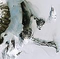 Satellitenbild von Black Island (Mitte rechts)
Weblinks
- Black Island im Global Volcanism Program der Smithsonian Institution (englisch).
- Black Island. In: Geographic Names Information System. United States Geological Survey, United States Department of the Interior, archiviert vom (englisch)..
- Black Island auf geographic.org (englisch).
Auf dieser Seite verwendete Medien
.jpg)
Mcmurdo (cropped).jpg
Koettlitz Glacier, Minna Bluff, Black Island & White Island
Koettlitz Glacier, Minna Bluff, Black Island & White Island

C78192s1 Ant.Map Mount Discovery.jpg
Map of Antarctica by the United States Antarctic Resource Center of the US Geological Society.
Map of Antarctica by the United States Antarctic Resource Center of the US Geological Society.

Antarctica relief location map.jpg
Autor/Urheber: Alexrk2, Lizenz: CC BY-SA 3.0
Physische Positionskarte Antarktis, Mittabstandstreue Azimutalprojektion
Autor/Urheber: Alexrk2, Lizenz: CC BY-SA 3.0
Physische Positionskarte Antarktis, Mittabstandstreue Azimutalprojektion
Black Island and Skidoos at Sunset.jpg
Autor/Urheber: Alan Light, Lizenz: CC BY 2.0
Black Island and Skidoos at Sunset
Autor/Urheber: Alan Light, Lizenz: CC BY 2.0
Black Island and Skidoos at Sunset