Birnie
| Birnie | ||
|---|---|---|
 | ||
| Gewässer | Pazifischer Ozean | |
| Inselgruppe | Phoenixinseln | |
| Geographische Lage | 3° 35′ 6″ S, 171° 31′ 0″ W | |
| Länge | 1,2 km | |
| Breite | 600 m | |
| Fläche | 72 ha | |
| Einwohner | unbewohnt | |
 | ||
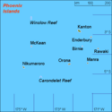
Birnie (englisch Birnie Island) ist eine kleine, unbewohnte Koralleninsel der kiribatischen Phoenixinseln. Die lediglich 1,2 km lange und 0,6 km breite Insel, die kleinste der Phoenixinseln, liegt im zentralen Pazifischen Ozean etwa 90 km westlich von Rawaki, der östlichsten Insel der Inselgruppe.
Die Insel ist ein gehobenes Atoll mit dem stark salzhaltigen Rest einer Lagune im Südwesten, die vom Meer vollständig getrennt ist. Wegen der unberührten Flora und Fauna ist Birnie ein wichtiges Naturschutzgebiet (Birnie Island Wildlife Sanctuary).
Birnie wurde 1823 vom Walfangschiff Sydney Packet unter Kapitän T. Emmett entdeckt und nach dem Schiffseigner, der Londoner Firma Alexander Birnie & Co, benannt.
Fotos
- Birnie Island, Signalturm im Hintergrund
- Birnie Island mit Signalturm
- Lagune im August 2008
- Vermessungszeichen des US Army Corps of Engineers
Literatur
- Henry Evans Maude: Of islands and men : studies in Pacific history. Melbourne [u. a.] : Oxford Univ. Pr., 1968
- A. G. E. Jones: Ships employed in the South Seas trade. Vol. 1: 1775–1861; Canberra 1986 & Vol. 2: 1775–1859; Burwood, Vic. [1992]
Weblinks
Auf dieser Seite verwendete Medien
(c) Joann94024 in der Wikipedia auf Englisch, CC BY-SA 3.0
Innere Lagune der Insel Birnie, Phönixinseln, Kiribati
(c) Joann94024 in der Wikipedia auf Englisch, CC BY-SA 3.0
United States Army Corps of Engineers Survey Mark on Birnie Island, Phoenix Islands, Kiribati.
(c) Joann94024 in der Wikipedia auf Englisch, CC BY-SA 3.0
Ruine des Signalturms auf der Insel Birnie, Phönixinseln, Kiribati
(c) Joann94024 in der Wikipedia auf Englisch, CC BY-SA 3.0
Strand der Insel Birnie, Phönixinseln, Kiribati
Autor/Urheber: Uwe Dedering, Lizenz: CC BY-SA 3.0
Location map of Kiribati
Equirectangular projection. Geographic limits of the map:
- N: 6° N
- S: 13° S
- W: 169° E
- E: 149° W
Made with Natural Earth. Free vector and raster map data @ naturalearthdata.com.
Sea-Borders from the political map made by NNWMap (rough) of the Phoenix islands, Kiribati, own work composed from various mapreferences
Autor/Urheber: EVS-Islands, Lizenz: CC BY 2.0
Map of Birnie Island, Phoenix Islands, Kiribati


