Bighorn National Forest
Bighorn National Forest IUCN-Kategorie VI – Protected Area with Sustainable use of Natural Resources | ||
 Blick auf das Gebiet | ||
| Lage | Wyoming, USA | |
| Fläche | 4.482 km²[1] | |
| Geographische Lage | 44° 32′ N, 107° 21′ W | |
| Einrichtungsdatum | 22. Februar 1897 | |
| Verwaltung | U.S. Forest Service | |
Der Bighorn National Forest ist ein in Wyoming gelegener National Forest. Das Gebiet umfasst eine Fläche von 4.482 km² und wurde nach dem Bighorn River benannt. Es liegt fast ausschließlich auf einer Höhe von über 1.500 m über dem Meeresspiegel. Die größte Erhebung ist mit 4.020 m der Cloud Peak in den Bighorn Mountains. Es ist einer der ältesten National Forest der Vereinigten Staaten.[2] Wie alle National Forests ist er im Bundesbesitz und wird intensiv forstwirtschaftlich genutzt.
Innerhalb des Waldes gibt es 32 Campingplätze, zudem ein Skigebiet und über 2.400 km Wanderwege.[3]
Flora und Fauna
Die Wälder werden hauptsächlich von Küsten-Kiefern, Fichten und Tannen dominiert. Zudem kommen Pappeln häufig vor. In den unbewaldeten Gebieten kommen Süßgräser und Artemisia-Arten vor.
Neben den Dickhornschafen kommen Schwarzbären, Gabelböcke und Pumas vor. Zu den größeren Vogelarten gehören Weißkopf-Seeadler und Steinadler.[4][5]
Schutzgebiete innerhalb des Waldes
Mit der Cloud Peak Wilderness gibt es ein Totalreservat, welches als Wilderness Area ausgezeichnet ist. Zudem ist hier das Medicine Mountain National Historic Landmark zu finden.[6]
Bilder

Herbst im Schutzgebiet
 (c) Scott Thompson, CC BY 3.0
Der Ten Sleep Creek

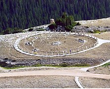
Ein Medicine Wheel im National Forest
Weblinks
Siehe auch
Einzelnachweise
- ↑ "Land Areas of the National Forest (englisch; PDF 2,82 MB), auf www.fs.fed.us im Januar 2012, abgerufen am 8. Juli 2017
- ↑ "Informationen zum Schutzgebiet" (englisch), abgerufen am 8. Juli 2017
- ↑ "Informationen zum Freizeitangebot" (englisch), abgerufen am 8. Juli 2017
- ↑ "Informationen zur Tierwelt" (Memento des vom 5. August 2017 im Internet Archive) Info: Der Archivlink wurde automatisch eingesetzt und noch nicht geprüft. Bitte prüfe Original- und Archivlink gemäß Anleitung und entferne dann diesen Hinweis. (englisch), abgerufen am 8. Juli 2017
- ↑ "Informationen zur Tierwelt" (englisch), abgerufen am 8. Juli 2017
- ↑ "Informationen zum Medicine Wheel" (englisch), abgerufen am 8. Juli 2017
Auf dieser Seite verwendete Medien

Medicine Wheel, a Native American sacred site and National Historic Landmark in Wyoming
_relief_location_map.png)
Autor/Urheber: TUBS
Location map of the USA (Hawaii and Alaska shown in sidemaps).
Main map: EquiDistantConicProjection : Central parallel :
* N: 37.0° N
Central meridian :
* E: 96.0° W
Standard parallels:
* 1: 32.0° N
* 2: 42.0° N
Made with Natural Earth. Free vector and raster map data @ naturalearthdata.com.
Formulas for x and y:
x = 50.0 + 124.03149777329222 * ((1.9694462586094064-({{{2}}}* pi / 180))
      * sin(0.6010514667026994 * ({{{3}}} + 96) * pi / 180))
y = 50.0 + 1.6155950752393982 * 124.03149777329222 * 0.02613325650382181
      - 1.6155950752393982  * 124.03149777329222 *
     (1.3236744353715044  - (1.9694462586094064-({{{2}}}* pi / 180))
      * cos(0.6010514667026994 * ({{{3}}} + 96) * pi / 180))
Hawaii side map: Equirectangular projection, N/S stretching 107 %. Geographic limits of the map:
- N: 22.4° N
- S: 18.7° N
- W: 160.7° W
- E: 154.6° W
Alaska side map: Equirectangular projection, N/S stretching 210.0 %. Geographic limits of the map:
- N: 72.0° N
- S: 51.0° N
- W: 172.0° E
- E: 129.0° W

Bighorn Mountains in early August just west of Buffalo, Wyoming.

Autumn in the Bighorn Mountains just west of Buffalo, Wyoming.
Autor/Urheber: Fabien Fivaz, Lizenz: CC BY 2.0
Bighorn National Forest, Wyoming
