Big Ben (Vulkan)
| Big Ben | ||
|---|---|---|
 Die Insel Heard mit Big Ben | ||
| Höhe | 2745 m | |
| Lage | Heard (Heard und McDonaldinseln) | |
| Koordinaten | 53° 6′ 5″ S, 73° 30′ 43″ O | |
| ||
| Typ | Schichtvulkan, aktiv | |
| Letzte Eruption | 2016 | |
Big Ben ist ein Schichtvulkan auf der unbewohnten subantarktischen Insel Heard, die zum australischen Außengebiet Heard und McDonaldinseln gehört. Der höchste Punkt (Mawson Peak, benannt nach dem australischen Polarforscher Douglas Mawson) liegt 2745 Meter über dem Meeresspiegel. Mit einer Fläche von etwa 360 km² bedeckt der Berg fast das gesamte Zentralgebiet der Insel.
Big Ben ist einer der beiden aktiven Vulkane von Australien und gleichzeitig der höchste Berg auf australischem Hoheitsgebiet.[1] Der Vulkan ist vollkommen von Schnee und Eis bedeckt, der Krater etwa 70 Meter tief.
Vulkanausbrüche fanden in den Jahren 1881, 1910, 1950–1952, 1953, 1954, 1985–1987, 1992, 1993, 2000–2001, 2003–2004 und 2006–2008 statt. Die jüngste Ausbruchsphase begann 2012[2] und dauert bis in die Gegenwart an.[3]
Die Erstbesteigung gelang 1964.[4]
Bildergalerie
 Satellitenaufnahme von Big Ben (2009)
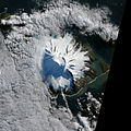 Satellitenaufnahme von Big Ben (2012)
Literatur
- Kevin Kiernan, Stu Fitch, Anne McConnell: Big Ben: the fire beneath the ice. In: Australian Antarctic Magazine. Nr. 2. Australian Antarctic Division, Juni 2002, ISSN 1445-1735, S. 31–32 (englisch, online [PDF; 8,5 MB]).
Weblinks
- Heard im Global Volcanism Program der Smithsonian Institution (englisch).
Einzelnachweise
- ↑ Heard Island: Der höchste Berg von Australien liegt in der Antarktis, Travelbook, 17. Dezember 2020
- ↑ Spektakuläres Video: Vulkanausbruch in der Antarktis. In: galileo.tv. 3. Februar 2016, abgerufen am 14. Juli 2019.
- ↑ Heard – Eruptive History. In: Global Volcanism Program. Smithsonian Institution, abgerufen am 14. Juli 2017 (englisch).
- ↑ Expeditionen-Erstbegehungen von Alpenklubmitgliedern – Österreichischer Alpenklub. Abgerufen am 23. November 2023 (deutsch).
Auf dieser Seite verwendete Medien
Heard Island

Heard Island is located in the southern Indian Ocean, approximately 1,550 kilometers (963 miles) north of Antarctica. The island is a visible part of the Kerguelen Plateau, a submerged feature on the seafloor. The plateau was formed when large amounts of volcanic rock erupted over a geologically short time period. (When large amounts of volcanic rock erupt beneath the ocean from processes other than seafloor spreading, geologists refer to them as large igneous provinces.) Most of Heard Island is formed from volcanic rocks associated with the Big Ben stratovolcano. The northeastern slopes of the volcano are visible in shadow at the lower right of this detailed astronaut photograph.
Recent volcanic activity at Heard Island has occurred at 2,745-meter (9,006-foot) Mawson Peak, which sits within a breached caldera on the southwestern side of the Big Ben Volcano. Calderas form when a magma chamber beneath a volcano empties and collapses. The shadow cast by Mawson Peak points directly to the crescent-shaped caldera rim. Detailed geologic study of Big Ben Volcano is complicated by the presence of several glaciers, including Gotley and Lied Glaciers on the southwestern slopes. This image, taken during Southern Hemisphere summer, also reveals non-glaciated volcanic rock (light to dark brown) on either side of Gotley Glacier.
| Identification | |
|---|---|
| Mission | ISS018 (Expedition 18) |
| Roll | E |
| Frame | 038182 |
| Country or Geographic Name | ANTARCTICA |
| Features | S.W. AREA OF HEARD I., MAWSON PEAK, FREMANTLE PEAK |
| Center Point Latitude | -53.1° N |
| Center Point Longitude | 73.5° E |
| Camera | |
| Camera Tilt | 36° |
| Camera Focal Length | 800 mm |
| Camera | Nikon D2Xs |
| Film | 4288 x 2848 pixel CMOS sensor, RGBG imager color filter. |
| Quality | |
| Percentage of Cloud Cover | 0-10% |
| Nadir What is Nadir? | |
| Date | 2009-02-28 |
| Time | 12:54:41 |
| Nadir Point Latitude | -51.3° N |
| Nadir Point Longitude | 71.9° E |
| Nadir to Photo Center Direction | Southeast |
| Sun Azimuth | 271° |
| Spacecraft Altitude | 197 nautical miles (365 km) |
| Sun Elevation Angle | 11° |
| Orbit Number | 2885 |

Autor/Urheber: Uwe Dedering, Lizenz: CC BY-SA 3.0
Relief location map of Indian Ocean.
- Projection: Lambert azimuthal equal-area projection.
- Area of interest:
- N: 30.0° N
- S: -70.0° N
- W: 30.0° E
- E: 150.0° E
- Projection center:
- NS: -20.0° N
- WE: 90.0° E
- GMT projection: -JA90.0/-20.0/180/19.998266666666666c
- GMT region: -R-12.856058461183775/-43.848273739920856/151.50519408595028/33.22162400070504r
- GMT region for grdcut: -R-13.0/-78.0/193.0/34.0r
- Relief: SRTM30plus.
- Made with Natural Earth. Free vector and raster map data @ naturalearthdata.com.

In October 2012, satellites measured subtle signals that suggested volcanic activity on remote Heard Island. These images, captured several months later, show proof of an eruption on Mawson Peak. By April 7, 2013, Mawson's steep-walled summit crater had filled, and a trickle of lava had spilled down the volcano’s southwestern flank. On April 20, the lava flow remained visible and had even widened slightly just below the summit. These natural-color images were collected by the Advanced Land Imager (ALI) on the Earth Observing-1 (EO-1) satellite.