Beauly Firth

Der Beauly Firth ist eine Bucht am Kopf des Meerearmes Moray Firth in der schottischen Council Area Highland. Sie reicht etwa 11 km in Ost-West-Richtung ins Land hinein und weist dabei eine maximale Breite von etwa 3 km auf. An ihrem Kopf liegt die Stadt Beauly, während sich Inverness am Beginn der Bucht befindet.[1]
Bei Beauly mündet der River Beauly von Westen kommend in den Beauly Firth. Einen weiteren Zulauf bildet der Ness, der in Inverness einmündet. Auch der Kaledonische Kanal endet in Inverness im Beauly Firth. Die Halbinsel Black Isle bildet das Nordufer der Bucht. Dort befindet sich gegenüber von Inverness mit North Kessock die einzige weitere bedeutende Ufersiedlung. Die zwischen 1976 und 1982 errichtete Kessock Bridge verbindet beide Orte miteinander. Sie führt mit der Fernstraße A9 einen der bedeutendsten Verkehrswege in den Highlands.[2] Zuvor bestand an dieser Stelle eine Fährverbindung.[3]
 (c) Dr Julian Paren, CC BY-SA 2.0Blick vom Nordufer des Beauly Firth
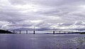 Kessock Bridge
Weblinks
Einzelnachweise
- ↑ Beauly Firth. In: David Munro, Bruce Gittings: Scotland. An Encyclopedia of Places & Landscapes. Collins u. a., Glasgow 2006, ISBN 0-00-472466-6.
- ↑ Kessock Bridge. In: David Munro, Bruce Gittings: Scotland. An Encyclopedia of Places & Landscapes. Collins u. a., Glasgow 2006, ISBN 0-00-472466-6.
- ↑ Kessock. In: Francis H. Groome: Ordnance Gazetteer of Scotland: A Survey of Scottish Topography, Statistical, Biographical and Historical. Band 4: (Har – Lib). Thomas C. Jack, Grange Publishing Works, Edinburgh u. a. 1885, S. 353.
Koordinaten: 57° 30′ N, 4° 20′ W
Auf dieser Seite verwendete Medien

(c) Dr Julian Paren, CC BY-SA 2.0
Trees on the coastline of the Black Isle Beyond the coastline is the Beauly Firth. The view was taken from one of the main tracks from Gallowhill Wood that heads towards Redcastle.

Autor/Urheber: dave conner, Lizenz: CC BY 2.0
Kessock Bridge and Beauly Firth Inverness Scotland
Autor/Urheber: Kmusser, Lizenz: CC BY-SA 2.5
This is a map of the Moray Firth including a small locator map, based on Digital Chart of the World data.