Bay of Isles
| Bay of Isles | ||
|---|---|---|
 Historische Aufnahme der Bay of Isles (zwischen 1900 und 1918) | ||
| Gewässer | Südatlantik | |
| Landmasse | Südgeorgien | |
| Geographische Lage | 54° S, 37° W | |
| ||
| Breite | 14,5 km | |
| Tiefe | 5 km | |
| Inseln | Albatross Island, Cleveland Rock, Crescent Island, Dot Island, Hecate Rock, Hogs Mouth Rocks, Inner Lee Island, Invisible Island, Mollyhawk Island, Outer Lee Island, Petrel Island, Prion Island, Seaward Rock, Skua Island, The Spike, Tern Island | |
| Zuflüsse | Lucas-Gletscher | |
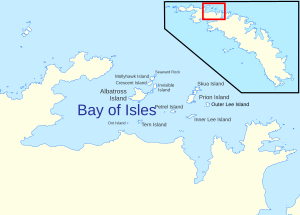
(c) South Georgia GIS, CC BY 1.0 Karte der Bay of Isles mit ihren Inseln | ||
Die Bay of Isles (englisch für Bucht der Inseln) ist eine Bucht an der Nordküste Südgeorgiens zwischen Kap Buller im Westen und Kap Wilson im Osten. Zu den Nebenbuchten der Bay of Isles gehören der Rosita Harbour, die Camp Bay, der Sunset-Fjord und der Sea Leopard Fjord.
Entdeckt und benannt wurde sie 1775 im Zuge der Zweiten Südseereise (1772–1775) des britischen Seefahrers und Entdeckers James Cook. Namensgebend waren die zahlreichen Inseln innerhalb der Bucht. Zu diesen Inseln zählen Albatross Island, Crescent Island, Invisible Island, Mollyhawk Island, Skua Island, Petrel Island, Prion Island, Tern Island, Dot Island und der Seaward Rock.
Weblinks
- Bay of Isles auf geographic.org (englisch)
- Bay of Isles. In: Geographic Names Information System. United States Geological Survey, United States Department of the Interior, archiviert vom (englisch).
Auf dieser Seite verwendete Medien
(c) South Georgia GIS, CC BY 1.0
The Bay of Isles, on the north coast of South Georgia
Autor/Urheber: Internet Archive Book Images, Lizenz: No restrictions
Title: The American Museum journal
Identifier: americanmuseumjo13amer (find matches)
Year: c1900-(1918) (c190s)
Authors: American Museum of Natural History
Subjects: Natural history
Publisher: New York : American Museum of Natural History
Contributing Library: American Museum of Natural History Library
Digitizing Sponsor: Biodiversity Heritage Library
View Book Page: Book Viewer
About This Book: Catalog Entry
View All Images: All Images From Book
Click here to view book online to see this illustration in context in a browseable online version of this book.
Text Appearing Before Image:
250 THE AMERICAN MUSEUM JOURNAL amain as one enters the cove, which might be likened to a great caldron so filled with the macerated bones of whales that they not only bestrew its bottom, but also thickly incrust its rim to the farthest highwater mark. During the next few days I discovered that not King Edward Cove alone, but indeed the whole beach of the south fjord of Cumberland Bay, a shore line of more than twenty-five miles, is lined with an almost inconceivable number of bones, mostly of the humpback whale. Spinal columns, loose vertebra?, flipper bones, ribs and jaws are piled in heaps and bulwarks, and I could count seventy-five or one hundred huge skulls without moving from one spot. The region is one enormous sepulcher, yet no one can guess how many hundreds or thousands of flensed carcasses have been carried out to sea by the tide, and so have sunk their skeletons in the deep. Such reckless
Text Appearing After Image:
The whaling brig "Daisy" at anchor in the Bay of Isles waste of a material which when manufactured into fertilizer is worth several pounds sterling a ton, was due to the exceeding abundance of whales in South Georgia waters and consequent neglect of all products of secondary importance to the blubber oil. But now the companies are required by law to utilize the entire carcass of the whale, and they have either installed bone- boiling and guano plants at their stations, or have sub-let this branch of the industries to "floating factories," that is vessels especially fitted for the purpose. One of this type, a 2000-ton full-rigged ship, was so occupied at the time of our visit. During our sojourn in Cumberland Bay the time was occupied with trips into the surrounding mountainous country, particularly about the magnifi- cent west fjord of the bay, a section reached overland from Grytviken through a high, extinct glacier bed, parts of which are smoothly paved with small fragments of shale packed edgewise by the ice in the manner of a
Note About Images
(c) Karte: NordNordWest, Lizenz: Creative Commons by-sa-3.0 de
Positionskarte von Südgeorgien


