Bannock County
 | |
| Verwaltung | |
|---|---|
| US-Bundesstaat: | Idaho |
| Verwaltungssitz: | Pocatello |
| Gründung: | 6. März 1893 |
| Gebildet aus: | Bingham County |
| Demographie | |
| Einwohner: | 87.018 (Stand: 2020) |
| Bevölkerungsdichte: | 30,17 Einwohner/km² |
| Geographie | |
| Fläche gesamt: | 2972 km² |
| Wasserfläche: | 88 km² |
| Karte | |
 | |
| Website: www.bannockcounty.us | |
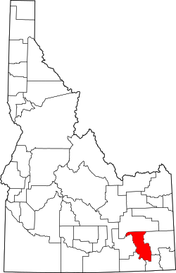
Bannock County[1] ist ein County im Bundesstaat Idaho der Vereinigten Staaten. Es liegt im südöstlichen Teil des Bundesstaates. Die Einwohnerzahl beträgt ca. 70.000, die Fläche 2972 Quadratkilometer.
Hauptstadt (County Seat) ist Pocatello mit knapp 55.000 Einwohnern. Des Weiteren zählen noch Orte wie Chubbuck und Inkom zum County.
Bekannt ist es unter anderem für das Skigebiet Pebble Creek, welches über die zweitsteilste Abfahrt der Vereinigten Staaten verfügt.
Teile des Caribou-Targhee National Forest befinden sich auf dem Gebiet von Bannock County.
Geschichte
Das Bannock County wurde am 6. März 1893 aus Teilen des Bingham Countys gebildet mit Pocatello als Sitz der Countyverwaltung (County Seat). Benannt wurde das County nach den Bannock-Indianern, die zuvor in diesem Gebiet beheimatet waren.
Im County liegt eine National Historic Landmark, das Fort Hall. 28 weitere Bauwerke und Stätten sind im National Register of Historic Places eingetragen.[2]
Bevölkerungsentwicklung
| Bevölkerungswachstum | |||
|---|---|---|---|
| Census | Einwohner | ± rel. | |
| 1900 | 11.702 | — | |
| 1910 | 19.242 | 64,4 % | |
| 1920 | 27.532 | 43,1 % | |
| 1930 | 31.266 | 13,6 % | |
| 1940 | 34.759 | 11,2 % | |
| 1950 | 41.745 | 20,1 % | |
| 1960 | 49.342 | 18,2 % | |
| 1970 | 52.200 | 5,8 % | |
| 1980 | 65.421 | 25,3 % | |
| 1990 | 66.026 | 0,9 % | |
| 2000 | 75.565 | 14,4 % | |
| 2010 | 82.839 | 9,6 % | |
| 2020 | 87.018 | 5 % | |
1900–1990[3] 2000 + 2010[4] | |||
Orte im Bannock County
|
|
Census-designated places (CDP)
|
|
1 – kleiner Teil im Power County
1 – teilweise im Bingham County
Weblinks
- Bannock County bei idaho.gov (engl.)
Einzelnachweise
- ↑ Bannock County. In: Geographic Names Information System. United States Geological Survey, United States Department of the Interior, abgerufen am 5. September 2024 (englisch).
- ↑ Suchmaske Datenbank im National Register Information System. National Park Service, abgerufen am 25. August 2017.
- ↑ Auszug aus Census.gov. Abgerufen am 14. Februar 2011
- ↑ Auszug aus census.gov (2000+2010) ( des vom 19. Mai 2012 im Internet Archive) Info: Der Archivlink wurde automatisch eingesetzt und noch nicht geprüft. Bitte prüfe Original- und Archivlink gemäß Anleitung und entferne dann diesen Hinweis. Abgerufen am 2. April 2012
Koordinaten: 42° 40′ N, 112° 13′ W
Auf dieser Seite verwendete Medien
This is a locator map showing Bannock County in Idaho. For more information, see Commons:United States county locator maps.
Autor/Urheber:
- real name: Artur Jan Fijałkowski
- pl.wiki: WarX
- commons: WarX
- mail: [1]
- jabber: WarX@jabber.org
- irc: [2]
- software: own perl scripts
Age pyramid for Bannock County, Idaho, United States of America, based on census 2000 data
Photograph of the Pocatello, Idaho, Federal Building & U.S. Courthouse, in the United States District Court for the District of Idaho


