Baimak
Stadt
| ||||||||||||||||||||||||||||||||||||||||||||
| ||||||||||||||||||||||||||||||||||||||||||||
| ||||||||||||||||||||||||||||||||||||||||||||
| Liste der Städte in Russland | ||||||||||||||||||||||||||||||||||||||||||||
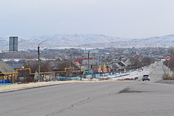
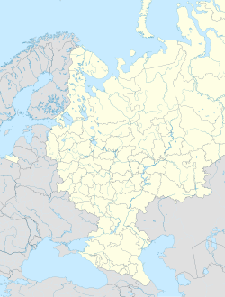
Baimak (russisch Байма́к, baschkirisch Баймаҡ/Bajmaq) ist eine Stadt in der Republik Baschkortostan (Russland) mit 17.710 Einwohnern (Stand 14. Oktober 2010).[1]
Geographie
Die Stadt liegt an der Ostflanke des Südlichen Ural, etwa 490 km südlich der Republikhauptstadt Ufa am Tanalyk, einem rechten Nebenfluss des Ural.
Baimak ist der Oblast administrativ direkt unterstellt und zugleich Verwaltungszentrum des gleichnamigen Rajons.
Geschichte
Baimak entstand 1913 als Siedlung bei einem Gold- und Kupferbergwerk und erhielt 1938 Stadtrecht.
Nachdem ein Gericht den baschkirischen Aktivisten Fail Alsynow zu vier Jahren Gefängnis verurteilt hatte, protestierten im Januar 2024 in Baimak einige Tausend Demonstranten für seine Freilassung und es kam zu gewalttätigen Auseinandersetzungen mit der Polizei. Nach Ansicht von Beobachtern handelte es sich um eine der größten Protestaktionen in Russland seit Beginn des Angriffskriegs gegen die Ukraine im März 2022.[2]
Bevölkerungsentwicklung
| Jahr | Einwohner |
|---|---|
| 1939 | 13.935 |
| 1959 | 11.335 |
| 1970 | 12.467 |
| 1979 | 13.453 |
| 1989 | 15.976 |
| 2002 | 17.223 |
| 2010 | 17.710 |
Anmerkung: Volkszählungsdaten
Weblinks
- Webseite der Rajonsverwaltung (russisch)
- Baimak auf mojgorod.ru (russisch)
Einzelnachweise
- ↑ a b Itogi Vserossijskoj perepisi naselenija 2010 goda. Tom 1. Čislennostʹ i razmeščenie naselenija (Ergebnisse der allrussischen Volkszählung 2010. Band 1. Anzahl und Verteilung der Bevölkerung). Tabellen 5, S. 12–209; 11, S. 312–979 (Download von der Website des Föderalen Dienstes für staatliche Statistik der Russischen Föderation)
- ↑ Proteste nach Urteil gegen Ökoaktivisten in Russland. In: Deutsche Welle. 17. Januar 2023, abgerufen am 17. Januar 2023.
Auf dieser Seite verwendete Medien
Autor/Urheber: Uwe Dedering, Lizenz: CC BY-SA 3.0
Location map of European_Russia.
- Projection: Lambert azimuthal equal-area projection.
- Area of interest:
- N: 75.0° N
- S: 40.0° N
- W: 25.0° E
- E: 60.0° E
- Projection center:
- NS: 57.5° N
- WE: 42.5° E
- GMT projection: -JA42.5/57.5/20c
- GMT region: -R25.450860698632475/38.37411418933942/86.79037939442836/70.79910933370674r
- GMT region for grdcut: -R-2.0/38.0/87.0/76.0r
- Made with Natural Earth. Free vector and raster map data @ naturalearthdata.com.
Baimak rayon (Bashkortostan), coat of arms
Позиционная карта Республики Башкортостан
- Проекция — равноугольная.
- Параметры шаблона (координаты краёв):
|top    = 56.6
|bottom = 51.5
|left   = 53.0
|right  = 60.2
State flag of the Republic of Bashkortostan


